Home » State Maps » Texas Physical Map

Texas Physical Map

Texas Physical Map

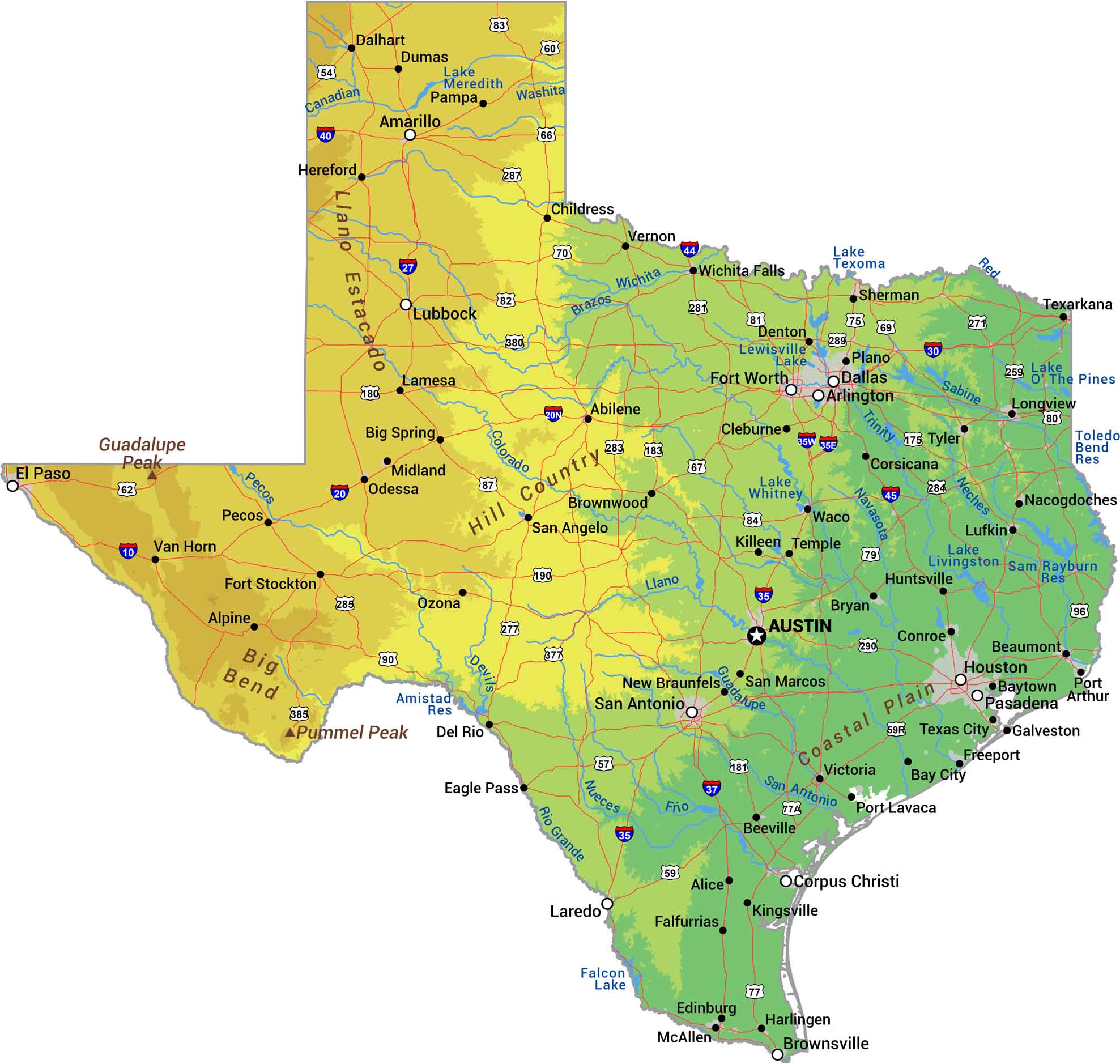
Everything’s bigger in Texas, including the geography. The Gulf Coast is flat and marshy, East Texas brings pine forests, and Central Texas rolls with Hill Country. Rivers like the Rio Grande and Brazos cut across hundreds of miles. Our physical map of Texas shows a state with more variety than most countries.

Map Information

  • State of Texas
  • Physical Map of Texas
  • Free for personal and commercial purpose. Attribution is required. How to attribute?

On the Map

Texas Location Map
Physical Features: Gulf Coastal Plain, Llano Estacado, Big Bend, Guadalupe Peak, Hill Country, Pummel Peak State Capital: Austin Major Cities: Amarillo, Arlington, Corpus Christi, Dallas, El Paso, Fort Worth, Houston, Laredo, Lubbock, Pasadena, San Antonio Cities and Towns: Abilene, Alice, Alpine, Bay City, Baytown, Beaumont, Beeville, Big Spring, Brownsville, Brownwood, Bryan, Childress, Cleburne, Conroe, Corsicana, Dalhart, Del Rio, Denton, Dumas, Eagle Pass, Edinburg, Falfurrias, Fort Stockton, Freeport, Galveston, Harlingen, Hereford, Huntsville, Killeen, Kingsville, Lamesa, Lewisville, Longview, Lufkin, McAllen, Midland, Nacogdoches, New Braunfels, Odessa, Ozona, Pampa, Pecos, Plano, Port Arthur, Port Lavaca, San Angelo, San Marcos, Sherman, Temple, Texarkana, Texas City, Tyler, Van Horn, Victoria, Waco, Wichita Falls Interstate Highways: I-10, I-20, I-27, I-30, I-35, I-37, I-40, I-44, I-45 US Routes: US-54, US-57, US-59, US-60, US-62, US-66, US-67, US-69, US-70, US-75, US-77, US-79, US-80, US-81, US-82, US-83, US-84, US-87, US-90, US-96, US-175, US-180, US-181, US-190, US-271, US-277, US-281, US-283, US-284, US-285, US-287, US-289, US-290, US-377, US-380, US-385 Lakes and Reservoirs: Amistad Reservoir, Falcon Lake, Lake Livingston, Lake Meredith, Lake Ray Hubbard, Lake Sam Rayburn Reservoir, Lake Texoma, Lake The Pines, Lake Whitney, Lewisville Lake, Toledo Bend Reservoir Rivers and Streams: Brazos River, Canadian River, Colorado River, Devils River, Frio River, Guadalupe River, Llano River, Navasota River, Neches River, Nueces River, Pecos River, Red River, Rio Grande, Sabine River, San Antonio River, Trinity River, Washita River, Wichita River

References

  1. Shuttle Radar Topography Mission Elevation
  2. National Map TopoBuilder Application

Leave a Reply

Your email address will not be published. Required fields are marked *