Home » State Maps » Indiana Physical Map

Indiana Physical Map

Indiana Physical Map

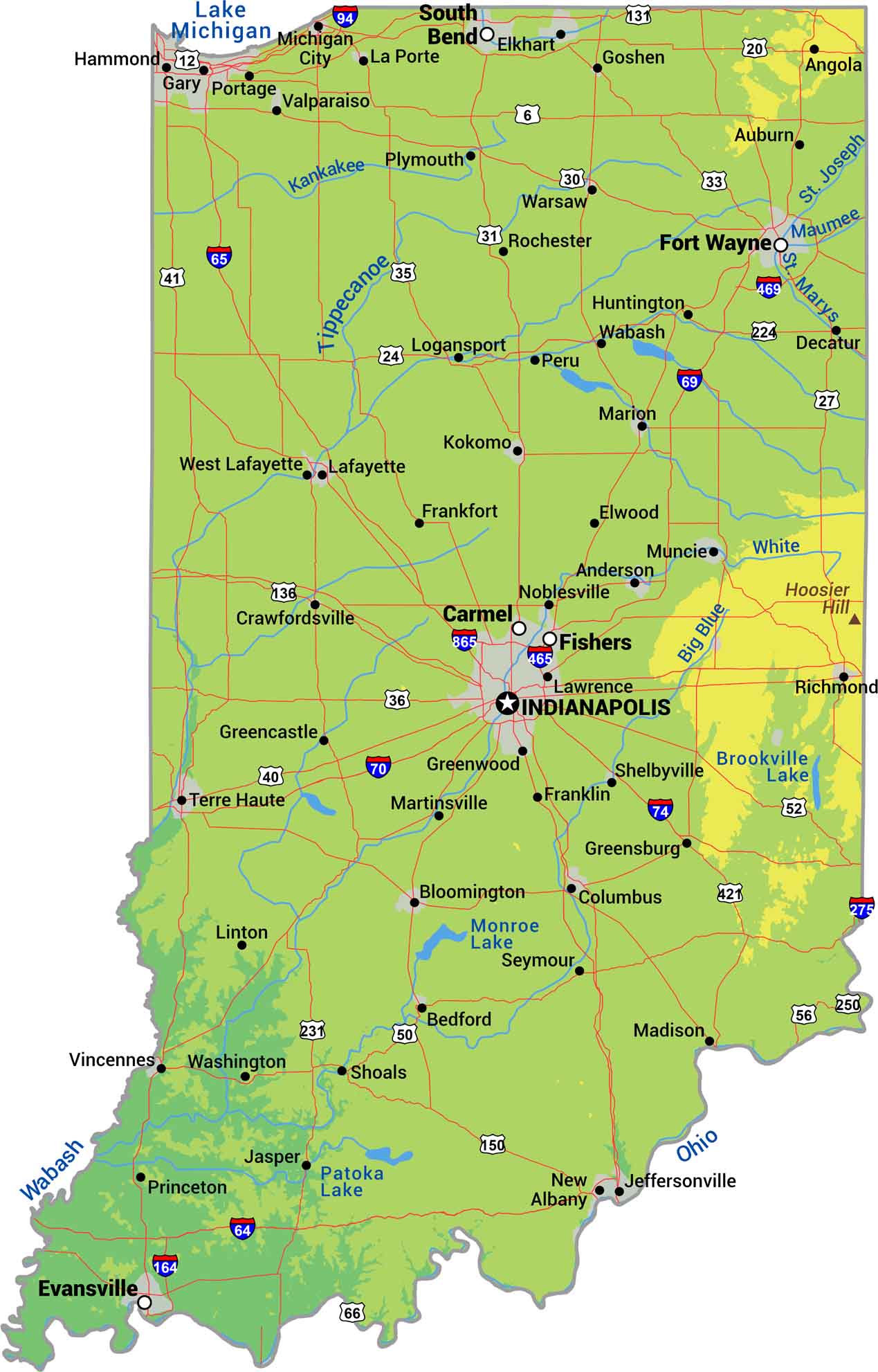
Try finding a mountain in Indiana because you won’t. This state is has some rolling hills but it’s mostly flat. Our physical map of Indiana shows flat farmland, river valleys, and terrain that made settlement and agriculture almost too easy.

Map Information

  • State of Indiana
  • Physical Map of Indiana
  • Free for personal and commercial purpose. Attribution is required. How to attribute?

On the Map

Indiana Location Map
Physical Features: Hoosier Hill State Capital: Indianapolis Major Cities: Evansville, Fort Wayne, South Bend Cities and Towns: Albany, Anderson, Angola, Auburn, Bedford, Bloomington, Carmel, Columbus, Crawfordsville, Decatur, Elkhart, Elwood, Fishers, Frankfort, Franklin, Gary, Goshen, Greencastle, Greensburg, Greenwood, Hammond, Huntington, Jasper, Jeffersonville, Kokomo, Lafayette, La Porte, Lawrence, Linton, Logansport, Madison, Marion, Martinsville, Michigan City, Muncie, New Albany, Noblesville, Peru, Plymouth, Portage, Princeton, Richmond, Rochester, Seymour, Shelbyville, Shoals, Terre Haute, Valparaiso, Vincennes, Wabash, Warsaw, Washington, West Lafayette Interstate Highways: I-64, I-65, I-69, I-70, I-74, I-80, I-94, I-164, I-275, I-465, I-469, I-865 US Routes: US Hwy 6, US Hwy 12, US Hwy 20, US Hwy 24, US Hwy 27, US Hwy 30, US Hwy 31, US Hwy 33, US Hwy 35, US Hwy 36, US Hwy 40, US Hwy 41, US Hwy 50, US Hwy 52, US Hwy 56, US Hwy 66, US Hwy 131, US Hwy 136, US Hwy 150, US Hwy 224, US Hwy 231, US Hwy 250, US Hwy 421 Lakes and Reservoirs: Brookville Lake, Lake Michigan, Monroe Lake, Patoka Lake Rivers and Streams: Big Blue River, Kankakee River, Maumee River, Ohio River, St. Joseph River, St. Marys River, Tippecanoe River, Wabash River, White River

References

  1. Shuttle Radar Topography Mission Elevation
  2. National Map TopoBuilder Application

Leave a Reply

Your email address will not be published. Required fields are marked *