Home » State Maps » Arizona Physical Map

Arizona Physical Map

Arizona Physical Map

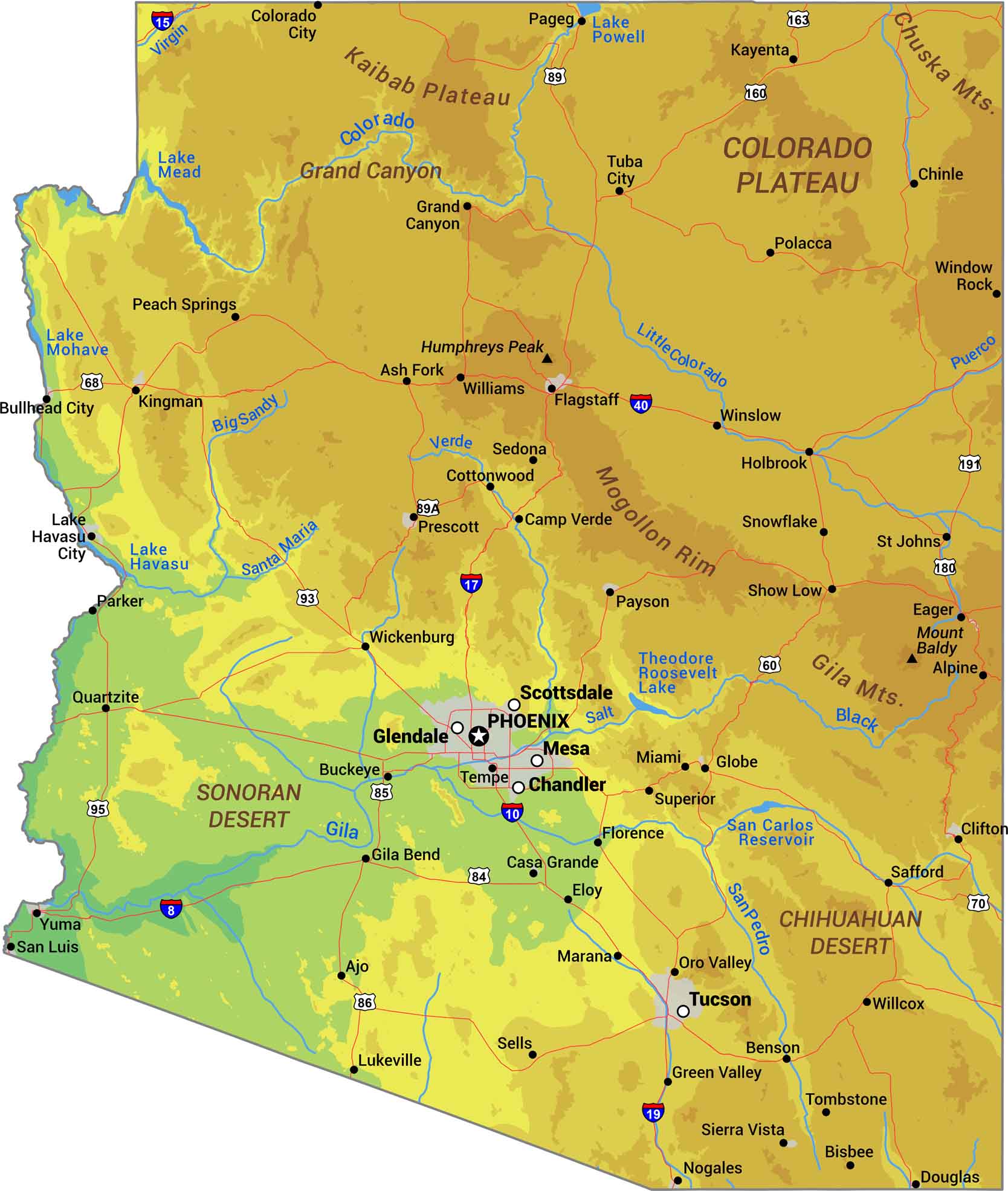
Our Arizona physical map captures the extremes. It includes everything from the Grand Canyon to the Sonoran Desert. The Colorado Plateau dominates the north while mountain ranges occupy through the southern desert. Use our map to explore the terrain across the state.

Map Information

  • State of Arizona
  • Physical Map of Arizona
  • Free for personal and commercial purpose. Attribution is required. How to attribute?

On the Map

Arizona Location Map
Physical Features: Chihuahuan Desert, Chuska Mts, Colorado Plateau, Gila Mts, Grand Canyon, Humphreys Peak, Kaibab Plateau, Mogollon Rim, Mount Baldy, Sonoran Desert State Capital: Phoenix Major Cities: Chandler, Glendale, Mesa, Scottsdale, Tucson Cities and Towns: Ajo, Alpine, Ash Fork, Benson, Bisbee, Buckeye, Bullhead City, Camp Verde, Casa Grande, Chinle, Clifton, Colorado City, Cottonwood, Douglas, Eager, Eloy, Flagstaff, Florence, Gila Bend, Globe, Grand Canyon, Green Valley, Holbrook, Kayenta, Kingman, Lake Havasu City, Lukeville, Marana, Miami, Nogales, Oro Valley, Pageg, Parker, Payson, Peach Springs, Polacca, Prescott, Quartzite, Safford, San Luis, Sedona, Sells, Show Low, Sierra Vista, Snowflake, St Johns, Superior, Tempe, Tombstone, Tuba City, Wickenburg, Willcox, Williams, Window Rock, Winslow, Yuma Interstate Highways: I-8, I-10, I-15, I-17, I-19, I-40 US Routes: U.S. 11, U.S. 29, U.S. 31, U.S. 43, U.S. 45, U.S. 72, U.S. 78, U.S. 80, U.S. 82, U.S. 84, U.S. 90, U.S. 98, U.S. 231, U.S. 278, U.S. 280, U.S. 331, U.S. 411, U.S. 431 Lakes and Reservoirs: Lake Mead, Lake Mohave, Lake Havasu, Lake Powell, Theodore Roosevelt Lake, San Carlos Reservoir Rivers and Streams: Colorado River, Little Colorado River, Gila River, Salt River, Verde River, Santa Maria River, Big Sandy River, San Pedro River, Puerco River, Black River National Parks and Forests: Grand Canyon National Park, Kaibab National Forest, Coconino National Forest, Prescott National Forest, Tonto National Forest, Apache National Forest, Coronado National Forest

References

  1. Shuttle Radar Topography Mission Elevation
  2. National Map TopoBuilder Application

Leave a Reply

Your email address will not be published. Required fields are marked *