Home » State Maps » Minnesota Physical Map

Minnesota Physical Map

Minnesota Physical Map

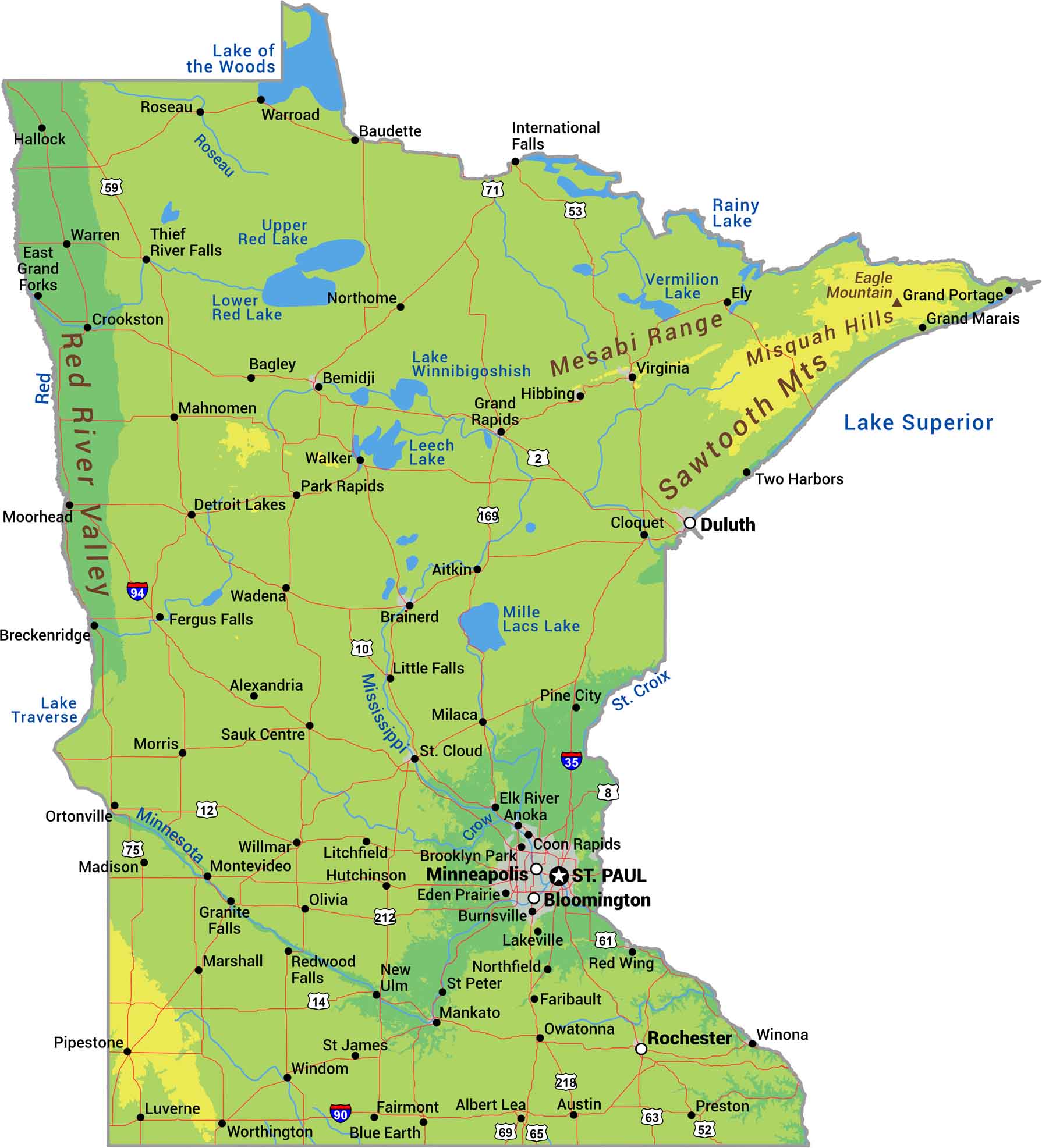
From the Sawtooth Mountains to the Red River Valley, this is our physical map of Minnesota. Over 10,000 lakes cluster in the north, and rivers like the Mississippi start their journey south through farmland. Water and ice built this landscape. But our physical map shows what they left behind.

Map Information

  • State of Minnesota
  • Physical Map of Minnesota
  • Free for personal and commercial purpose. Attribution is required. How to attribute?

On the Map

Minnesota Location Map
Physical Features: Mesabi Range, Misquah Hills, Sawtooth Mts, Eagle Mountain, Red River Valley State Capital: St. Paul Major Cities: Bloomington, Duluth, Minneapolis, Rochester Cities and Towns: Aitkin, Albert Lea, Alexandria, Anoka, Austin, Bagley, Baudette, Bemidji, Blue Earth, Brainerd, Breckenridge, Brooklyn Park, Burnsville, Cloquet, Coon Rapids, Crookston, Detroit Lakes, East Grand Forks, Eden Prairie, Elk River, Ely, Fairmont, Faribault, Fergus Falls, Grand Marais, Grand Portage, Grand Rapids, Granite Falls, Hallock, Hibbing, Hutchinson, International Falls, Lakeville, Litchfield, Little Falls, Luverne, Madison, Mahnomen, Mankato, Marshall, Milaca, Montevideo, Moorhead, Morris, New Ulm, Northfield, Northome, Ortonville, Owatonna, Park Rapids, Pine City, Pipestone, Preston, Red Wing, Redwood Falls, Roseau, Sauk Centre, St. Cloud, St. James, St. Peter, Thief River Falls, Two Harbors, Virginia, Wadena, Walker, Warren, Warroad, Willmar, Winona, Worthington Interstate Highways: I-35, I-90, I-94 US Routes: US-10, US-12, US-14, US-169, US-2, US-212, US-218, US-52, US-53, US-59, US-61, US-63, US-65, US-69, US-71, US-75, US-8 Lakes and Reservoirs: Lake of the Woods, Lake Superior, Lake Traverse, Lake Winnibigoshish, Leech Lake, Lower Red Lake, Mille Lacs Lake, Rainy Lake, Upper Red Lake, Vermilion Lake Rivers and Streams: Crow River, Minnesota River, Mississippi River, Red River, Roseau River, St. Croix River

References

  1. Shuttle Radar Topography Mission Elevation
  2. National Map TopoBuilder Application

Leave a Reply

Your email address will not be published. Required fields are marked *