Tennessee County Map
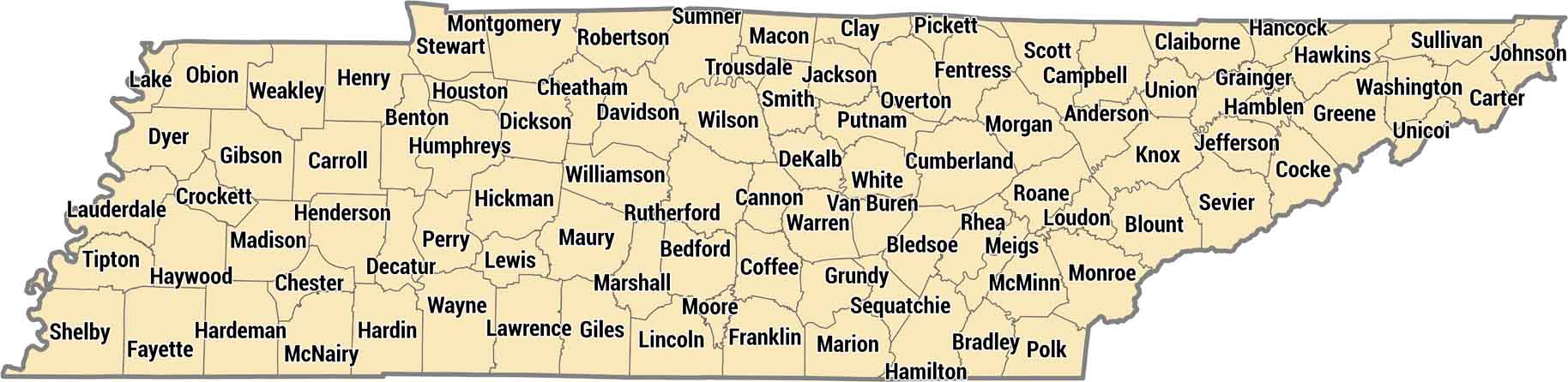
Tennessee’s 95 counties stretch across three distinct regions from the Appalachians to the Mississippi River. The eastern mountain counties are completely different terrain from the flat Delta farmland. Shelby County has Memphis way out west, Davidson County is Nashville in the middle.
Map Information
On the Map
Our table below provides you with population, area, and FIPS code for each county.
|
Name |
Population 2024 |
Total Area (sq mi) |
FIPS Code |
|
Anderson County |
81,449 |
344.8 |
47-001 |
|
Bedford County |
54,228 |
474.8 |
47-003 |
|
Benton County |
16,173 |
436.2 |
47-005 |
|
Bledsoe County |
15,591 |
406.7 |
47-007 |
|
Blount County |
142,211 |
566.6 |
47-009 |
|
Bradley County |
113,782 |
331.4 |
47-011 |
|
Campbell County |
40,238 |
498.1 |
47-013 |
|
Cannon County |
15,142 |
265.7 |
47-015 |
|
Carroll County |
29,107 |
600.1 |
47-017 |
|
Carter County |
57,434 |
347.7 |
47-019 |
|
Cheatham County |
42,604 |
307.1 |
47-021 |
|
Chester County |
17,876 |
286 |
47-023 |
|
Claiborne County |
33,070 |
441.6 |
47-025 |
|
Clay County |
7,857 |
259.3 |
47-027 |
|
Cocke County |
37,596 |
443.1 |
47-029 |
|
Coffee County |
61,285 |
434.6 |
47-031 |
|
Crockett County |
13,973 |
265.7 |
47-033 |
|
Cumberland County |
65,618 |
684.8 |
47-035 |
|
Davidson County |
729,505 |
525.3 |
47-037 |
|
Decatur County |
11,800 |
344.9 |
47-039 |
|
DeKalb County |
21,747 |
329 |
47-041 |
|
Dickson County |
57,641 |
491.3 |
47-043 |
|
Dyer County |
36,403 |
526.5 |
47-045 |
|
Fayette County |
44,476 |
706.2 |
47-047 |
|
Fentress County |
20,129 |
498.9 |
47-049 |
|
Franklin County |
45,137 |
575.7 |
47-051 |
|
Gibson County |
51,422 |
603.6 |
47-053 |
|
Giles County |
30,971 |
611.2 |
47-055 |
|
Grainger County |
25,073 |
302.4 |
47-057 |
|
Greene County |
73,398 |
624.1 |
47-059 |
|
Grundy County |
14,148 |
361.1 |
47-061 |
|
Hamblen County |
67,715 |
175.8 |
47-063 |
|
Hamilton County |
386,256 |
575.8 |
47-065 |
|
Hancock County |
7,038 |
223.5 |
47-067 |
|
Hardeman County |
25,434 |
670.4 |
47-069 |
|
Hardin County |
27,617 |
596.3 |
47-071 |
|
Hawkins County |
59,371 |
499.6 |
47-073 |
|
Haywood County |
17,097 |
534.1 |
47-075 |
|
Henderson County |
28,183 |
525.9 |
47-077 |
|
Henry County |
32,883 |
593.4 |
47-079 |
|
Hickman County |
25,859 |
612.6 |
47-081 |
|
Houston County |
8,538 |
207 |
47-083 |
|
Humphreys County |
19,554 |
556.7 |
47-085 |
|
Jackson County |
12,376 |
319.5 |
47-087 |
|
Jefferson County |
59,217 |
314.3 |
47-089 |
|
Johnson County |
18,506 |
302.7 |
47-091 |
|
Knox County |
506,748 |
525.9 |
47-093 |
|
Lake County |
6,422 |
193.9 |
47-095 |
|
Lauderdale County |
24,630 |
507.6 |
47-097 |
|
Lawrence County |
46,467 |
618 |
47-099 |
|
Lewis County |
13,418 |
282.5 |
47-101 |
|
Lincoln County |
36,751 |
570.7 |
47-103 |
|
Loudon County |
62,129 |
247.4 |
47-105 |
|
McMinn County |
56,754 |
432.2 |
47-107 |
|
McNairy County |
26,103 |
563.6 |
47-109 |
|
Macon County |
27,189 |
307.2 |
47-111 |
|
Madison County |
100,409 |
558.6 |
47-113 |
|
Marion County |
29,826 |
512.3 |
47-115 |
|
Marshall County |
37,847 |
376.2 |
47-117 |
|
Maury County |
113,411 |
615.6 |
47-119 |
|
Meigs County |
13,937 |
216.7 |
47-121 |
|
Monroe County |
49,154 |
652.6 |
47-123 |
|
Montgomery County |
246,025 |
543.8 |
47-125 |
|
Moore County |
6,773 |
130.4 |
47-127 |
|
Morgan County |
21,954 |
522.5 |
47-129 |
|
Obion County |
30,261 |
555.4 |
47-131 |
|
Overton County |
23,551 |
434.8 |
47-133 |
|
Perry County |
8,987 |
422.9 |
47-135 |
|
Pickett County |
5,108 |
174.5 |
47-137 |
|
Polk County |
18,338 |
442.3 |
47-139 |
|
Putnam County |
84,894 |
402.6 |
47-141 |
|
Rhea County |
34,759 |
336.4 |
47-143 |
|
Roane County |
56,742 |
395 |
47-145 |
|
Robertson County |
78,459 |
476.5 |
47-147 |
|
Rutherford County |
376,996 |
624.1 |
47-149 |
|
Scott County |
22,517 |
533.2 |
47-151 |
|
Sequatchie County |
17,620 |
266 |
47-153 |
|
Sevier County |
100,184 |
597.7 |
47-155 |
|
Shelby County |
910,530 |
785 |
47-157 |
|
Smith County |
20,783 |
325.4 |
47-159 |
|
Stewart County |
14,365 |
493 |
47-161 |
|
Sullivan County |
162,703 |
429.7 |
47-163 |
|
Sumner County |
211,721 |
543.2 |
47-165 |
|
Tipton County |
62,187 |
473.3 |
47-167 |
|
Trousdale County |
12,159 |
116.6 |
47-169 |
|
Unicoi County |
17,872 |
186.4 |
47-171 |
|
Union County |
21,064 |
247.1 |
47-173 |
|
Van Buren County |
6,686 |
274.5 |
47-175 |
|
Warren County |
43,619 |
434 |
47-177 |
|
Washington County |
139,642 |
329.8 |
47-179 |
|
Wayne County |
15,974 |
735.7 |
47-181 |
|
Weakley County |
33,162 |
581.8 |
47-183 |
|
White County |
29,108 |
379.4 |
47-185 |
|
Williamson County |
269,136 |
584 |
47-187 |
|
Wilson County |
169,948 |
583.5 |
47-189 |
Tennessee State Maps
Here are our state maps of Tennessee.


State County Maps
Click on a map below to check out county maps of each state.


