Ohio County Map
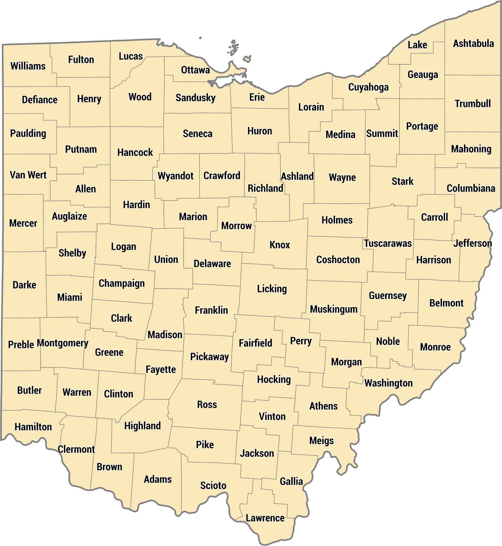
Our Ohio county map shows 88 counties from Lake Erie down to the Ohio River. The Ohio River forms the state’s southern border while the Southeast counties are Appalachian foothills. Cuyahoga County holds Cleveland on the lake and Franklin County has Columbus in the center.
Map Information
On the Map
Our table below provides you with population, area, and FIPS code for each county.
|
Name |
Population 2024 |
Total Area (sq mi) |
FIPS Code |
|
Adams County |
27,671 |
586.2 |
39-001 |
|
Allen County |
100,866 |
406.8 |
39-003 |
|
Ashland County |
52,420 |
426.8 |
39-005 |
|
Ashtabula County |
96,906 |
1,367.90 |
39-007 |
|
Athens County |
63,218 |
508.4 |
39-009 |
|
Auglaize County |
45,922 |
401.9 |
39-011 |
|
Belmont County |
64,692 |
541.3 |
39-013 |
|
Brown County |
44,292 |
493.4 |
39-015 |
|
Butler County |
399,542 |
470 |
39-017 |
|
Carroll County |
26,460 |
398.9 |
39-019 |
|
Champaign County |
38,907 |
429.8 |
39-021 |
|
Clark County |
134,985 |
402.5 |
39-023 |
|
Clermont County |
214,123 |
459.8 |
39-025 |
|
Clinton County |
42,019 |
412.3 |
39-027 |
|
Columbiana County |
99,823 |
534.7 |
39-029 |
|
Coshocton County |
37,003 |
567.5 |
39-031 |
|
Crawford County |
41,626 |
402.7 |
39-033 |
|
Cuyahoga County |
1,240,594 |
1,245.50 |
39-035 |
|
Darke County |
51,462 |
599.7 |
39-037 |
|
Defiance County |
38,644 |
414.2 |
39-039 |
|
Delaware County |
237,966 |
457.3 |
39-041 |
|
Erie County |
73,841 |
625.9 |
39-043 |
|
Fairfield County |
167,762 |
508.6 |
39-045 |
|
Fayette County |
28,782 |
407 |
39-047 |
|
Franklin County |
1,356,303 |
543.6 |
39-049 |
|
Fulton County |
42,028 |
407.2 |
39-051 |
|
Gallia County |
28,886 |
471.2 |
39-053 |
|
Geauga County |
95,362 |
408.3 |
39-055 |
|
Greene County |
172,347 |
416.3 |
39-057 |
|
Guernsey County |
38,219 |
528.3 |
39-059 |
|
Hamilton County |
837,359 |
412.6 |
39-061 |
|
Hancock County |
75,016 |
533.7 |
39-063 |
|
Hardin County |
30,402 |
470.6 |
39-065 |
|
Harrison County |
14,042 |
410.8 |
39-067 |
|
Henry County |
27,536 |
419.7 |
39-069 |
|
Highland County |
43,785 |
557.8 |
39-071 |
|
Hocking County |
27,429 |
423.6 |
39-073 |
|
Holmes County |
44,668 |
424 |
39-075 |
|
Huron County |
58,168 |
494.8 |
39-077 |
|
Jackson County |
32,723 |
421.5 |
39-079 |
|
Jefferson County |
63,900 |
411 |
39-081 |
|
Knox County |
63,848 |
529.6 |
39-083 |
|
Lake County |
232,360 |
979.2 |
39-085 |
|
Lawrence County |
55,829 |
457.3 |
39-087 |
|
Licking County |
184,898 |
687.4 |
39-089 |
|
Logan County |
46,085 |
466.8 |
39-091 |
|
Lorain County |
322,030 |
923.4 |
39-093 |
|
Lucas County |
426,291 |
595.8 |
39-095 |
|
Madison County |
45,531 |
466.6 |
39-097 |
|
Mahoning County |
225,786 |
425.2 |
39-099 |
|
Marion County |
64,976 |
404.1 |
39-101 |
|
Medina County |
184,625 |
423 |
39-103 |
|
Meigs County |
21,491 |
433 |
39-105 |
|
Mercer County |
42,648 |
473.4 |
39-107 |
|
Miami County |
111,950 |
409.6 |
39-109 |
|
Monroe County |
13,051 |
457.5 |
39-111 |
|
Montgomery County |
537,443 |
464.4 |
39-113 |
|
Morgan County |
13,532 |
421.8 |
39-115 |
|
Morrow County |
35,927 |
407.2 |
39-117 |
|
Muskingum County |
86,582 |
672.6 |
39-119 |
|
Noble County |
14,269 |
404.6 |
39-121 |
|
Ottawa County |
39,692 |
585.1 |
39-123 |
|
Paulding County |
18,755 |
418.8 |
39-125 |
|
Perry County |
35,682 |
412.5 |
39-127 |
|
Pickaway County |
62,158 |
506.5 |
39-129 |
|
Pike County |
27,065 |
444 |
39-131 |
|
Portage County |
163,839 |
504.1 |
39-133 |
|
Preble County |
40,801 |
426.6 |
39-135 |
|
Putnam County |
34,206 |
484.3 |
39-137 |
|
Richland County |
124,853 |
500.1 |
39-139 |
|
Ross County |
76,046 |
693 |
39-141 |
|
Sandusky County |
58,866 |
417.7 |
39-143 |
|
Scioto County |
71,798 |
616.1 |
39-145 |
|
Seneca County |
54,730 |
552.8 |
39-147 |
|
Shelby County |
47,952 |
410.7 |
39-149 |
|
Stark County |
374,091 |
580.6 |
39-151 |
|
Summit County |
538,370 |
420.1 |
39-153 |
|
Trumbull County |
200,300 |
636.6 |
39-155 |
|
Tuscarawas County |
92,048 |
571.4 |
39-157 |
|
Union County |
71,721 |
436.9 |
39-159 |
|
Van Wert County |
28,887 |
410.4 |
39-161 |
|
Vinton County |
12,545 |
415 |
39-163 |
|
Warren County |
256,059 |
407.3 |
39-165 |
|
Washington County |
58,332 |
640 |
39-167 |
|
Wayne County |
116,632 |
556.8 |
39-169 |
|
Williams County |
36,554 |
423.1 |
39-171 |
|
Wood County |
133,077 |
620.5 |
39-173 |
|
Wyandot County |
21,394 |
407.6 |
39-175 |
Ohio State Maps
Check out our maps covering farmland or any of Ohio’s major cities.


State County Maps
Click on a map below to check out county maps of each state.


