Home » State Maps » Pennsylvania Physical Map

Pennsylvania Physical Map

Pennsylvania Physical Map

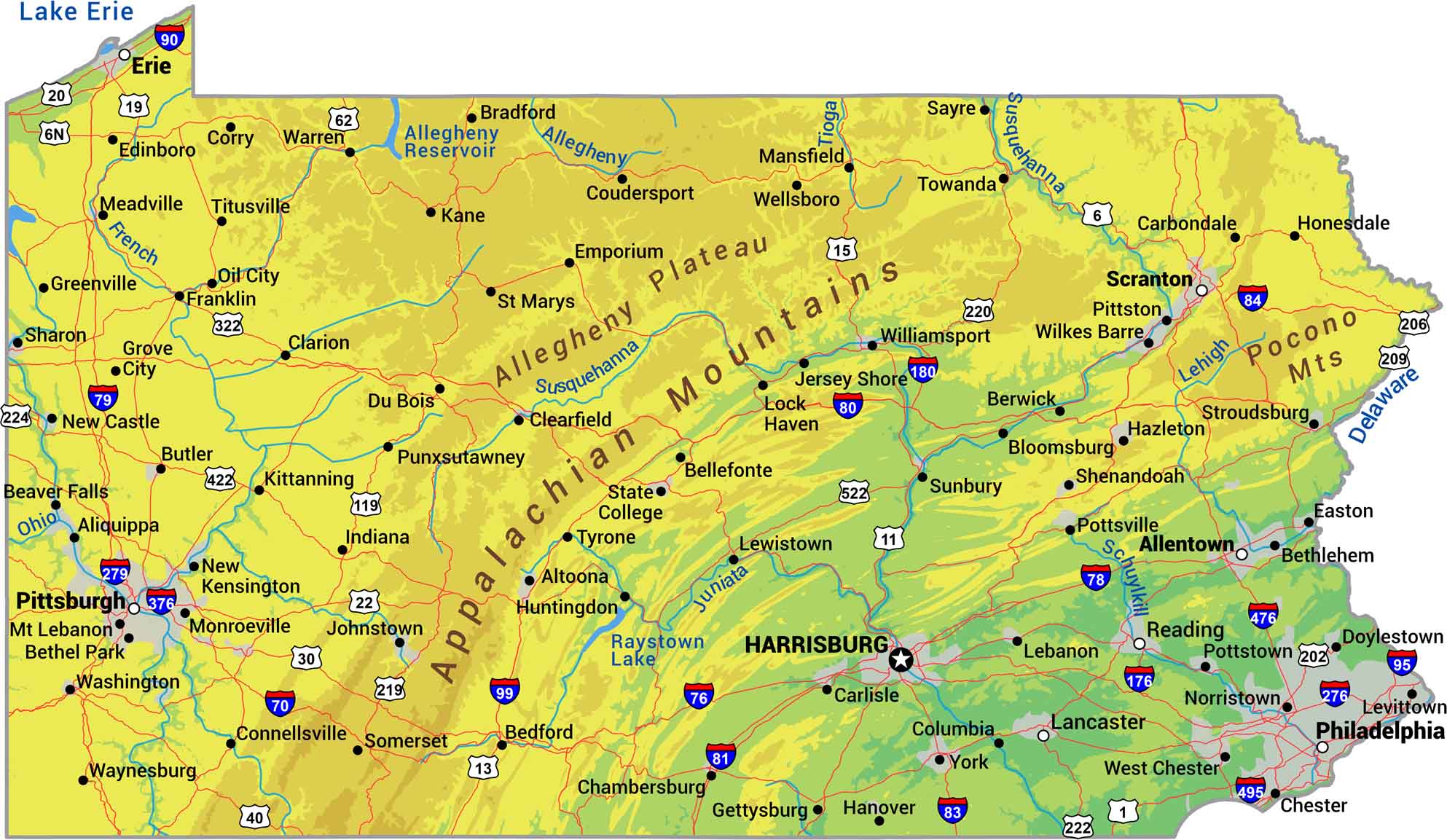
Pennsylvania is Appalachian ridges and valleys from end to end. The mountains run diagonally across the state with the Allegheny Plateau filling the northwest. Eastern Pennsylvania transitions from highlands to rolling Piedmont near Philadelphia. Rivers like the Susquehanna, Allegheny, and Delaware cut through it all.

Map Information

  • State of Pennsylvania
  • Physical Map of Pennsylvania
  • Free for personal and commercial purpose. Attribution is required. How to attribute?

On the Map

Pennsylvania Location Map
Physical Features: Appalachian Mountains, Allegheny Plateau, Pocono Mts State Capital: Harrisburg Major Cities: Allentown, Erie, Philadelphia, Pittsburgh, Scranton Cities and Towns: Aliquippa, Altoona, Beaver Falls, Bedford, Bellefonte, Berwick, Bethel Park, Bethlehem, Bloomsburg, Bradford, Butler, Carbondale, Carlisle, Chambersburg, Chester, Clarion, Clearfield, Columbia, Connellsville, Corry, Coudersport, Doylestown, Du Bois, Easton, Edinboro, Emporium, Franklin, Gettysburg, Greenville, Grove City, Hanover, Hazleton, Honesdale, Huntingdon, Indiana, Jersey Shore, Johnstown, Kane, Kittanning, Lancaster, Lebanon, Levittown, Lewistown, Mansfield, Meadville, Monroe Ville, Mt Lebanon, New Castle, New Kensington, Norristown, Oil City, Pittston, Pottstown, Pottsville, Punxsutawney, Reading, Sayre, Sharon, Shenandoah, Somerset, State College, Stroudsburg, Sunbury, Titusville, Towanda, Tyrone, Warren, Washington, Waynesburg, Wellsboro, West Chester, Wilkes-Barre, Williamsport, York Interstate Highways: I-70, I-76, I-78, I-79, I-80, I-81, I-83, I-84, I-90, I-95, I-99, I-176, I-180, I-276, I-279, I-376, I-380, I-476 US Routes: US-1, US-6, US-6N, US-11, US-13, US-15, US-19, US-20, US-22, US-30, US-40, US-62, US-119, US-202, US-206, US-209, US-219, US-220, US-222, US-322, US-422, US-522 Lakes and Reservoirs: Allegheny Reservoir, Lake Erie, Raystown Lake Rivers and Streams: Allegheny River, Delaware River, French River, Juniata River, Lehigh River, Ohio River, Schuylkill River, Susquehanna River, Tioga River

References

  1. Shuttle Radar Topography Mission Elevation
  2. National Map TopoBuilder Application

Leave a Reply

Your email address will not be published. Required fields are marked *