Home » State Maps » Florida Population Map

Florida Population Map

Florida Population Density Map

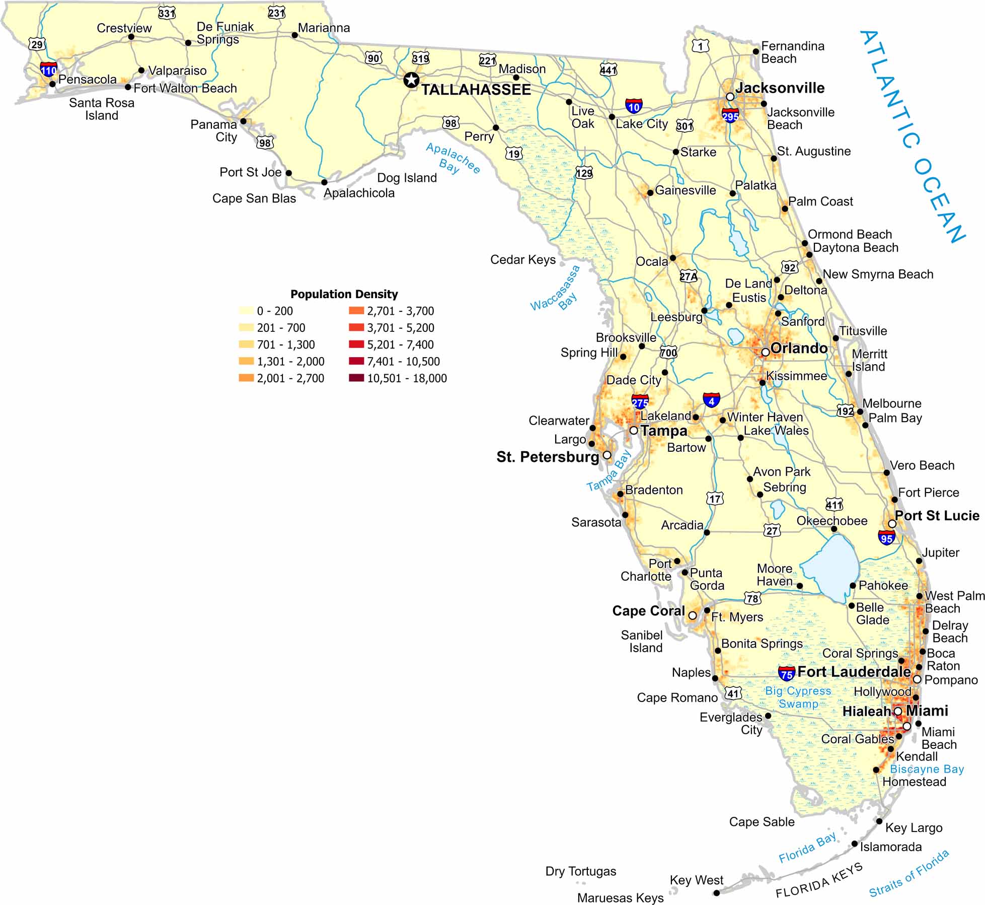
Florida’s population hugs the coast and major metros. But interior wetlands and the panhandle zone appear far less dense. Check out our Florida population density map to see how water and shoreline shape settlement here.

Map Information

  • Population Density Map of Florida
  • Data provided by NASA SEDAC Gridded Population of the World
  • Free for personal and commercial purpose. Attribution is required. How to attribute?

On the Map

Florida Location Map
State Capital: Tallahassee Major Cities: Cape Coral, Fort Lauderdale, Hialeah, Jacksonville, Miami, Orlando, Port St Lucie, St. Petersburg, Tampa Cities and Towns: Apalachicola, Arcadia, Avon Park, Bartow, Belle Glade, Boca Raton, Bonita Springs, Bradenton, Brooksville, Clearwater, Coral Gables, Coral Springs, Crestview, Dade City, Daytona Beach, De Funiak Springs, De Land, Delray Beach, Deltona, Eustis, Everglades City, Fernandina Beach, Fort Pierce, Fort Walton Beach, Ft. Myers, Gainesville, Hollywood, Homestead, Islamorada, Jacksonville Beach, Jupiter, Kendall, Key Largo, Key West, Kissimmee, Lake City, Lake Wales, Lakeland, Largo, Leesburg, Live Oak, Madison, Marianna, Melbourne, Merritt Island, Miami Beach, Moore Haven, Naples, New Smyrna Beach, Ocala, Okeechobee, Ormond Beach, Pahokee, Palatka, Palm Bay, Palm Coast, Panama City, Pensacola, Perry, Pompano, Port Charlotte, Port St Joe, Punta Gorda, Sanford, Sarasota, Sebring, Spring Hill, St. Augustine, Starke, Titusville, Valparaiso, Vero Beach, West Palm Beach, Winter Haven

Leave a Reply

Your email address will not be published. Required fields are marked *