Home » State Maps » Colorado Population Map

Colorado Population Map

Colorado Population Density Map

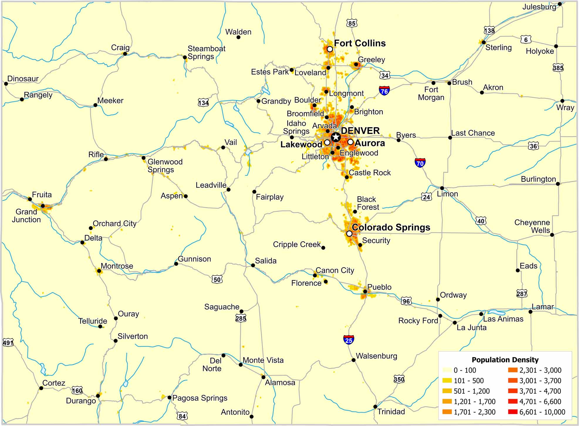
Most residents in Colorado live along the eastern edge of the Rockies. The Front Range forms a clear north–south corridor. Check out our map to see density fall quickly westward as elevation strongly limits settlement.

Map Information

  • Population Density Map of Colorado
  • Data provided by NASA SEDAC Gridded Population of the World
  • Free for personal and commercial purpose. Attribution is required. How to attribute?

On the Map

Colorado Location Map
State Capital: Denver Major Cities: Aurora, Colorado Springs, Fort Collins, Lakewood Cities and Towns: Akron, Alamosa, Antonito, Arvada, Aspen, Black Forest, Boulder, Brighton, Broomfield, Brush, Burlington, Byers, Canon City, Castle Rock, Cheyenne Wells, Cortez, Craig, Cripple Creek, Del Norte, Delta, Dinosaur, Durango, Eads, Englewood, Estes Park, Fairplay, Florence, Fort Morgan, Fruita, Glenwood Springs, Grand Junction, Grandby, Greeley, Gunnison, Holyoke, Idaho Springs, Julesburg, La Junta, Lamar, Las Animas, Last Chance, Leadville, Limon, Littleton, Longmont, Loveland, Meeker, Monte Vista, Montrose, Orchard City, Ordway, Ouray, Pagosa Springs, Pueblo, Rangely, Rifle, Rocky Ford, Saguache, Salida, Security, Silverton, Springfield, Steamboat Springs, Sterling, Telluride, Trinidad, Vail, Walden, Walsenburg, Wray Interstate Highways: I-25, I-70, I-76, I-225, I-270 US Routes: U.S. Hwy 6, U.S. Hwy 24, U.S. Hwy 34, U.S. Hwy 36, U.S. Hwy 40, U.S. Hwy 50, U.S. Hwy 84, U.S. Hwy 85, U.S. Hwy 96, U.S. Hwy 134, U.S. Hwy 138, U.S. Hwy 160, U.S. Hwy 285, U.S. Hwy 287, U.S. Hwy 350, U.S. Hwy 385, U.S. Hwy 491, U.S. Hwy 550

Leave a Reply

Your email address will not be published. Required fields are marked *