Home » State Maps » Tennessee Population Map

Tennessee Population Map

Tennessee Population Density Map

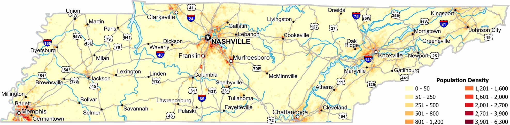
Population spreads across several urban areas rather than just one. Our population density map of Tennessee shows settlement following valleys and river systems. You’ll also notice that mountainous eastern regions appear less dense.

Map Information

  • Population Density Map of Tennessee
  • Data provided by NASA SEDAC Gridded Population of the World
  • Free for personal and commercial purpose. Attribution is required. How to attribute?

On the Map

Tennessee Location Map
State Capital: Nashville Major Cities: Chattanooga, Clarksville, Franklin, Knoxville, Memphis, Murfreesboro Cities and Towns: Athens, Barlett, Bolivar, Brownsville, Cleveland, Columbia, Cookeville, Dickson, Dyersburg, Fayetteville, Gallatin, Gatlinburg, Germantown, Greeneville, Jackson, Johnson City, Kingsport, Lawrenceburg, Lebanon, Lexington, Linden, Livingston, Martin, Maryville, McMinnville, Milan, Millington, Morristown, Newport, Oak Ridge, Oneida, Paris, Pulaski, Savannah, Selmer, Shelbyville, Tullahoma, Union City, Waverly Interstate Highways: I-24, I-26, I-40, I-64, I-65, I-75, I-81, I-140, I-155, I-181 US Routes: US-11, US-19, US-25, US-27, US-31, US-41, US-43, US-45, US-51, US-54, US-64, US-70, US-70S, US-72, US-74, US-79, US-127, US-129, US-138, US-231, US-321, US-411, US-412, US-431, US-441, US-641

Leave a Reply

Your email address will not be published. Required fields are marked *