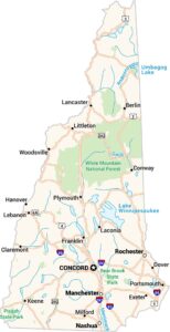
New Hampshire County Map

New Hampshire’s counties run from the Atlantic shoreline through forests and up into the White Mountains. Our map shows how the northern counties widen as the land opens up. With just 10 counties, you can see why it’s such a compact New England state.
Map Information
On the Map
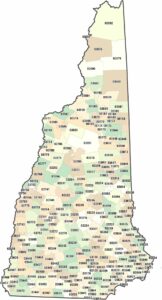
Our table below provides you with population, area, and FIPS code for each county.
|
Name |
Population 2024 |
Total Area (sq mi) |
FIPS Code |
|
Belknap County |
65,257 |
470 |
33-001 |
|
Carroll County |
52,580 |
993.5 |
33-003 |
|
Cheshire County |
78,078 |
728.9 |
33-005 |
|
Coos County |
31,094 |
1,830.30 |
33-007 |
|
Grafton County |
93,045 |
1,749.70 |
33-009 |
|
Hillsborough County |
430,462 |
892.5 |
33-011 |
|
Merrimack County |
157,869 |
955 |
33-013 |
|
Rockingham County |
322,433 |
795.2 |
33-015 |
|
Strafford County |
134,202 |
382.6 |
33-017 |
|
Sullivan County |
44,012 |
552.1 |
33-019 |
New Hampshire State Maps
Select one of our maps of the Granite State.


State County Maps
Click on a map below to check out county maps of each state.


