Colorado Counties and Cities Map
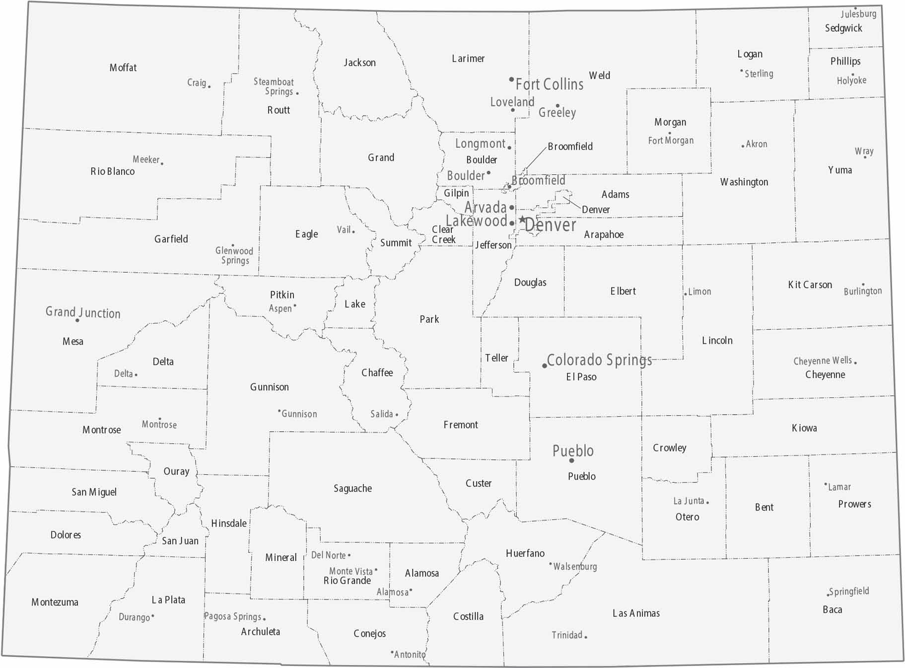
Counties form a grid across the plains, shifting to irregular shapes in the mountains. Cities line up along the Front Range in counties like Denver, Boulder, and El Paso. But the eastern plains have bigger, flatter counties with fewer cities as you head toward Kansas. See it all on our map of Colorado with cities and counties.
Map Information
On the Map
|
Name |
Population 2024 |
Total Area (sq mi) |
FIPS Code |
|
Adams County |
542,973 |
1,183.40 |
08-001 |
|
Alamosa County |
16,689 |
723.3 |
08-003 |
|
Arapahoe County |
666,918 |
805.5 |
08-005 |
|
Archuleta County |
14,112 |
1,355.40 |
08-007 |
|
Baca County |
3,367 |
2,557.30 |
08-009 |
|
Bent County |
5,779 |
1,541.10 |
08-011 |
|
Boulder County |
330,262 |
740.5 |
08-013 |
|
Broomfield County |
78,323 |
33.5 |
08-014 |
|
Chaffee County |
20,780 |
1,014.90 |
08-015 |
|
Cheyenne County |
1,712 |
1,781.40 |
08-017 |
|
Clear Creek County |
9,076 |
396.5 |
08-019 |
|
Conejos County |
7,549 |
1,291.00 |
08-021 |
|
Costilla County |
3,686 |
1,231.00 |
08-023 |
|
Crowley County |
5,600 |
800.3 |
08-025 |
|
Custer County |
5,553 |
739.9 |
08-027 |
|
Delta County |
32,215 |
1,148.60 |
08-029 |
|
Denver County |
729,019 |
154.9 |
08-031 |
|
Dolores County |
2,467 |
1,068.20 |
08-033 |
|
Douglas County |
393,995 |
842.9 |
08-035 |
|
Eagle County |
54,330 |
1,691.80 |
08-037 |
|
Elbert County |
29,382 |
1,851.00 |
08-039 |
|
El Paso County |
752,772 |
2,129.60 |
08-041 |
|
Fremont County |
50,093 |
1,533.90 |
08-043 |
|
Garfield County |
63,167 |
2,955.80 |
08-045 |
|
Gilpin County |
5,963 |
150.3 |
08-047 |
|
Grand County |
16,154 |
1,869.60 |
08-049 |
|
Gunnison County |
17,310 |
3,259.60 |
08-051 |
|
Hinsdale County |
747 |
1,123.10 |
08-053 |
|
Huerfano County |
6,988 |
1,593.30 |
08-055 |
|
Jackson County |
1,273 |
1,621.00 |
08-057 |
|
Jefferson County |
578,533 |
774.1 |
08-059 |
|
Kiowa County |
1,392 |
1,786.00 |
08-061 |
|
Kit Carson County |
7,080 |
2,161.70 |
08-063 |
|
Lake County |
7,369 |
383.9 |
08-065 |
|
La Plata County |
56,823 |
1,699.60 |
08-067 |
|
Larimer County |
374,574 |
2,634.00 |
08-069 |
|
Las Animas County |
14,518 |
4,775.60 |
08-071 |
|
Lincoln County |
5,598 |
2,586.50 |
08-073 |
|
Logan County |
20,755 |
1,844.90 |
08-075 |
|
Mesa County |
161,260 |
3,341.10 |
08-077 |
|
Mineral County |
933 |
877.8 |
08-079 |
|
Moffat County |
13,142 |
4,750.90 |
08-081 |
|
Montezuma County |
26,841 |
2,039.80 |
08-083 |
|
Montrose County |
44,806 |
2,242.80 |
08-085 |
|
Morgan County |
30,300 |
1,293.90 |
08-087 |
|
Otero County |
17,991 |
1,269.70 |
08-089 |
|
Ouray County |
5,197 |
542.2 |
08-091 |
|
Park County |
18,316 |
2,210.70 |
08-093 |
|
Phillips County |
4,488 |
688 |
08-095 |
|
Pitkin County |
16,643 |
973.2 |
08-097 |
|
Prowers County |
11,957 |
1,644.30 |
08-099 |
|
Pueblo County |
169,866 |
2,397.80 |
08-101 |
|
Rio Blanco County |
6,607 |
3,222.80 |
08-103 |
|
Rio Grande County |
11,132 |
912.3 |
08-105 |
|
Routt County |
25,243 |
2,368.10 |
08-107 |
|
Saguache County |
6,670 |
3,170.30 |
08-109 |
|
San Juan County |
821 |
388.3 |
08-111 |
|
San Miguel County |
7,819 |
1,288.70 |
08-113 |
|
Sedgwick County |
2,257 |
549.4 |
08-115 |
|
Summit County |
30,882 |
619.3 |
08-117 |
|
Teller County |
24,862 |
558.9 |
08-119 |
|
Washington County |
4,771 |
2,523.90 |
08-121 |
|
Weld County |
369,745 |
4,016.70 |
08-123 |
|
Yuma County |
10,048 |
2,368.70 |
08-125 |
Counties and Cities Maps
Select any state map below to view its counties and cities map.


Colorado State Maps
Browse Colorado with our detailed state maps


