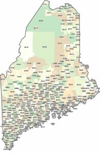
Maine County Map

Our Maine county map shows 16 counties from the coast to the Canadian border. Aroostook County up north is huge and rural. Coastal counties like Cumberland have the cities and tourist towns. Our county map of Maine shows how the coastline creates irregular shapes while the interior stays broad and open.
Map Information
On the Map
Our table below provides you with population, area, and FIPS code for each county.
|
Name |
Population 2024 |
Total Area (sq mi) |
FIPS Code |
|
Androscoggin County |
115,272 |
497.1 |
23-001 |
|
Aroostook County |
66,776 |
6,827.50 |
23-003 |
|
Cumberland County |
313,809 |
1,217.50 |
23-005 |
|
Franklin County |
30,902 |
1,743.80 |
23-007 |
|
Hancock County |
56,946 |
2,344.90 |
23-009 |
|
Kennebec County |
128,461 |
951.2 |
23-011 |
|
Knox County |
40,981 |
1,143.90 |
23-013 |
|
Lincoln County |
36,491 |
699.6 |
23-015 |
|
Oxford County |
60,039 |
2,175.70 |
23-017 |
|
Penobscot County |
156,840 |
3,557.00 |
23-019 |
|
Piscataquis County |
17,432 |
4,378.00 |
23-021 |
|
Sagadahoc County |
37,582 |
370 |
23-023 |
|
Somerset County |
51,338 |
4,093.40 |
23-025 |
|
Waldo County |
40,617 |
852.8 |
23-027 |
|
Washington County |
31,383 |
3,257.70 |
23-029 |
|
York County |
220,143 |
1,269.70 |
23-031 |


State County Maps
Click on a map below to check out county maps of each state.


