Arkansas County Map
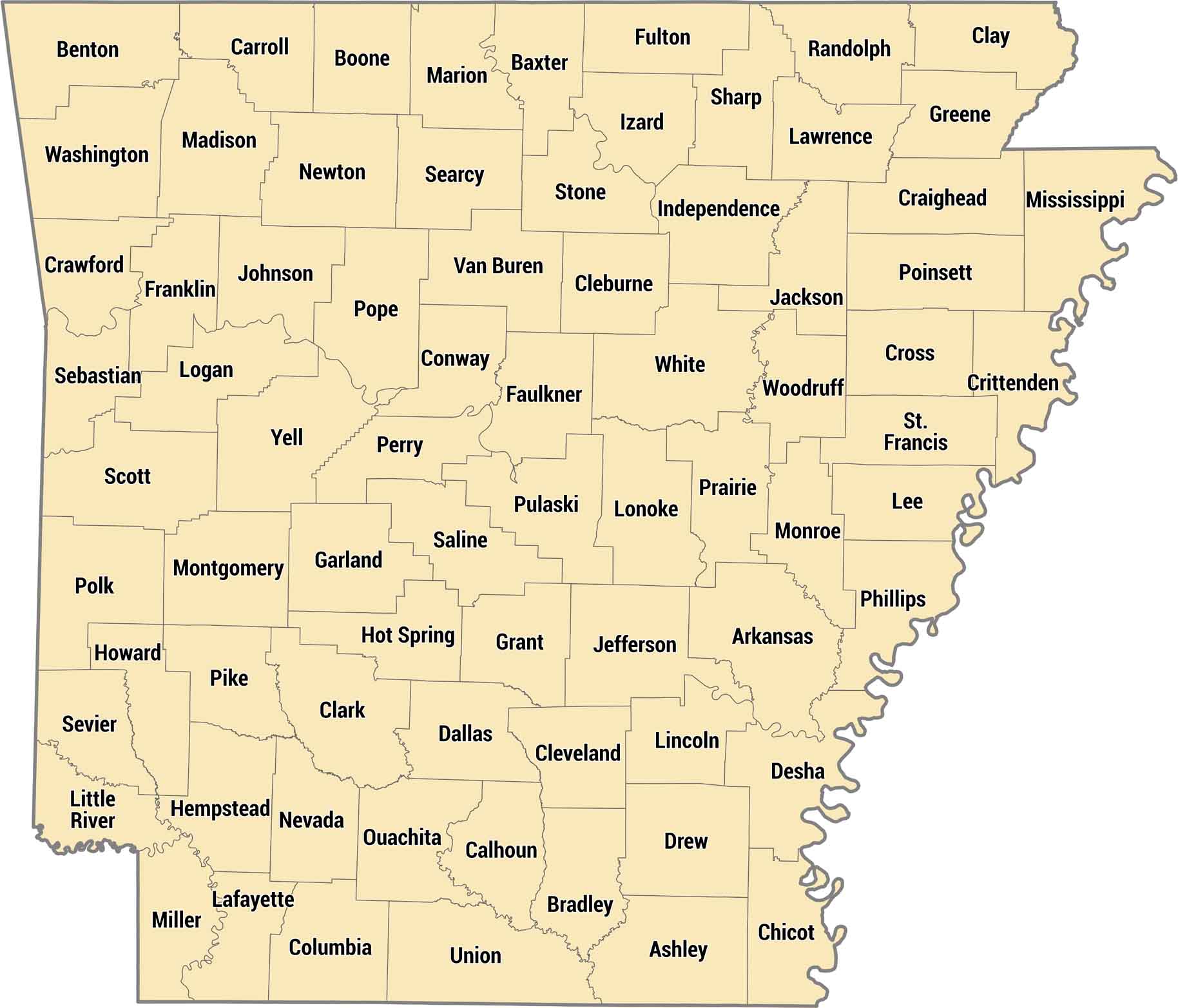
Our Arkansas county map shows all 75 counties across varied terrain. Arkansas counties stretch from the rugged Ozarks to the flat, fertile Delta. Our county map of Arkansas highlights how geography shapes the state, with rivers marking many boundaries.
Map Information
On the Map
Our table below provides you with population, area, and FIPS code for each county.
|
Name |
Population 2024 |
Total Area (sq mi) |
FIPS Code |
|
Arkansas County |
16,050 |
1,033.70 |
05-001 |
|
Ashley County |
17,984 |
940.5 |
05-003 |
|
Baxter County |
43,007 |
586.7 |
05-005 |
|
Benton County |
321,566 |
883.9 |
05-007 |
|
Boone County |
38,636 |
602 |
05-009 |
|
Bradley County |
9,935 |
652.9 |
05-011 |
|
Calhoun County |
4,690 |
632.4 |
05-013 |
|
Carroll County |
28,968 |
638.6 |
05-015 |
|
Chicot County |
9,272 |
690.8 |
05-017 |
|
Clark County |
20,920 |
882.8 |
05-019 |
|
Clay County |
14,112 |
641.4 |
05-021 |
|
Cleburne County |
25,646 |
591.9 |
05-023 |
|
Cleveland County |
7,367 |
598.7 |
05-025 |
|
Columbia County |
22,024 |
766.7 |
05-027 |
|
Conway County |
21,422 |
566.7 |
05-029 |
|
Craighead County |
115,852 |
712.7 |
05-031 |
|
Crawford County |
62,258 |
603.2 |
05-033 |
|
Crittenden County |
46,633 |
636.4 |
05-035 |
|
Cross County |
16,194 |
622.3 |
05-037 |
|
Dallas County |
6,076 |
668.1 |
05-039 |
|
Desha County |
10,321 |
819.5 |
05-041 |
|
Drew County |
16,935 |
835.7 |
05-043 |
|
Faulkner County |
131,611 |
664.1 |
05-045 |
|
Franklin County |
17,586 |
619.6 |
05-047 |
|
Fulton County |
12,546 |
620.3 |
05-049 |
|
Garland County |
99,902 |
734.6 |
05-051 |
|
Grant County |
18,546 |
632.9 |
05-053 |
|
Greene County |
46,928 |
579.5 |
05-055 |
|
Hempstead County |
19,105 |
741.2 |
05-057 |
|
Hot Spring County |
33,313 |
622.2 |
05-059 |
|
Howard County |
12,387 |
595.3 |
05-061 |
|
Independence County |
38,345 |
771.5 |
05-063 |
|
Izard County |
14,291 |
584 |
05-065 |
|
Jackson County |
16,673 |
641.5 |
05-067 |
|
Jefferson County |
63,672 |
913.8 |
05-069 |
|
Johnson County |
26,172 |
682.7 |
05-071 |
|
Lafayette County |
6,015 |
545.1 |
05-073 |
|
Lawrence County |
16,305 |
592.3 |
05-075 |
|
Lee County |
8,104 |
619.5 |
05-077 |
|
Lincoln County |
12,868 |
572.2 |
05-079 |
|
Little River County |
11,626 |
564.8 |
05-081 |
|
Logan County |
21,457 |
731.5 |
05-083 |
|
Lonoke County |
76,389 |
802.8 |
05-085 |
|
Madison County |
17,865 |
837.1 |
05-087 |
|
Marion County |
17,593 |
640.3 |
05-089 |
|
Miller County |
41,958 |
637.6 |
05-091 |
|
Mississippi County |
38,095 |
919.8 |
05-093 |
|
Monroe County |
6,415 |
621.3 |
05-095 |
|
Montgomery County |
8,510 |
800.3 |
05-097 |
|
Nevada County |
8,004 |
620.6 |
05-099 |
|
Newton County |
7,026 |
823.2 |
05-101 |
|
Ouachita County |
21,684 |
739.7 |
05-103 |
|
Perry County |
10,251 |
560.5 |
05-105 |
|
Phillips County |
14,661 |
727.3 |
05-107 |
|
Pike County |
10,027 |
614.1 |
05-109 |
|
Poinsett County |
22,300 |
763.6 |
05-111 |
|
Polk County |
19,434 |
862.5 |
05-113 |
|
Pope County |
64,829 |
830.8 |
05-115 |
|
Prairie County |
7,935 |
675.6 |
05-117 |
|
Pulaski County |
401,209 |
807.7 |
05-119 |
|
Randolph County |
19,040 |
656 |
05-121 |
|
St. Francis County |
21,822 |
642.5 |
05-123 |
|
Saline County |
131,252 |
730.5 |
05-125 |
|
Scott County |
9,837 |
898 |
05-127 |
|
Searcy County |
7,836 |
668.5 |
05-129 |
|
Sebastian County |
130,035 |
547.2 |
05-131 |
|
Sevier County |
15,735 |
581.3 |
05-133 |
|
Sharp County |
18,130 |
606.4 |
05-135 |
|
Stone County |
12,785 |
609.4 |
05-137 |
|
Union County |
37,008 |
1,055.20 |
05-139 |
|
Van Buren County |
16,152 |
724.3 |
05-141 |
|
Washington County |
266,184 |
952.4 |
05-143 |
|
White County |
79,091 |
1,042.10 |
05-145 |
|
Woodruff County |
5,808 |
594 |
05-147 |
|
Yell County |
20,134 |
948.9 |
05-149 |
Arkansas State Maps
Check out our Arkansas maps here


State County Maps
Click on a map below to check out county maps of each state.


