Alabama County Map
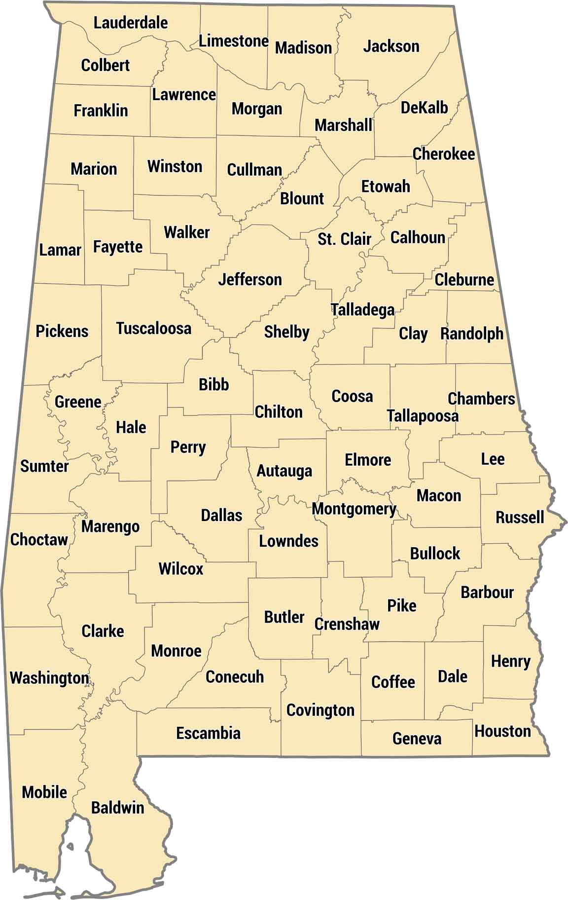
Our Alabama county map shows all 67 counties in the state. Baldwin County stretches along the Gulf Coast in the south, while counties in the northeast sit in the Appalachian foothills. The state’s geography ranges from beaches to mountains. You can see how the counties follow these natural features.
Map Information
On the Map
Our table below provides you with population, area, and FIPS code for each county.
|
Name |
Population 2024 |
Total Area (sq mi) |
FIPS Code |
|
Autauga County |
61,464 |
604.4 |
01-001 |
|
Baldwin County |
261,608 |
2,027.30 |
01-003 |
|
Barbour County |
24,358 |
904.5 |
01-005 |
|
Bibb County |
22,258 |
626.2 |
01-007 |
|
Blount County |
60,163 |
650.6 |
01-009 |
|
Bullock County |
9,901 |
625.1 |
01-011 |
|
Butler County |
18,256 |
777.9 |
01-013 |
|
Calhoun County |
116,427 |
612.3 |
01-015 |
|
Chambers County |
33,813 |
603.1 |
01-017 |
|
Cherokee County |
26,138 |
600 |
01-019 |
|
Chilton County |
47,262 |
700.8 |
01-021 |
|
Choctaw County |
12,052 |
920.9 |
01-023 |
|
Clarke County |
22,142 |
1,252.60 |
01-025 |
|
Clay County |
14,239 |
606 |
01-027 |
|
Cleburne County |
15,905 |
561 |
01-029 |
|
Coffee County |
56,358 |
680.5 |
01-031 |
|
Colbert County |
58,785 |
623.5 |
01-033 |
|
Conecuh County |
11,109 |
852.8 |
01-035 |
|
Coosa County |
10,291 |
666.3 |
01-037 |
|
Covington County |
37,748 |
1,043.80 |
01-039 |
|
Crenshaw County |
13,114 |
610.9 |
01-041 |
|
Cullman County |
92,604 |
755 |
01-043 |
|
Dale County |
50,067 |
562.7 |
01-045 |
|
Dallas County |
35,545 |
993.8 |
01-047 |
|
DeKalb County |
73,122 |
778.7 |
01-049 |
|
Elmore County |
91,042 |
657 |
01-051 |
|
Escambia County |
36,630 |
953.1 |
01-053 |
|
Etowah County |
103,207 |
548.6 |
01-055 |
|
Fayette County |
15,863 |
629.4 |
01-057 |
|
Franklin County |
31,874 |
646.5 |
01-059 |
|
Geneva County |
27,259 |
578.9 |
01-061 |
|
Greene County |
7,127 |
659.9 |
01-063 |
|
Hale County |
15,116 |
656.5 |
01-065 |
|
Henry County |
18,141 |
568.3 |
01-067 |
|
Houston County |
109,366 |
581.7 |
01-069 |
|
Jackson County |
53,780 |
1,126.80 |
01-071 |
|
Jefferson County |
664,744 |
1,124.10 |
01-073 |
|
Lamar County |
13,543 |
605.5 |
01-075 |
|
Lauderdale County |
97,502 |
719.6 |
01-077 |
|
Lawrence County |
33,567 |
717.2 |
01-079 |
|
Lee County |
187,847 |
615.8 |
01-081 |
|
Limestone County |
118,942 |
607.2 |
01-083 |
|
Lowndes County |
9,485 |
725.1 |
01-085 |
|
Macon County |
18,159 |
613.2 |
01-087 |
|
Madison County |
423,355 |
812.7 |
01-089 |
|
Marengo County |
18,512 |
982.7 |
01-091 |
|
Marion County |
29,323 |
743.6 |
01-093 |
|
Marshall County |
102,156 |
623.2 |
01-095 |
|
Mobile County |
412,339 |
1,644.00 |
01-097 |
|
Monroe County |
19,057 |
1,034.40 |
01-099 |
|
Montgomery County |
225,894 |
799.9 |
01-101 |
|
Morgan County |
126,084 |
599 |
01-103 |
|
Perry County |
7,719 |
723.9 |
01-105 |
|
Pickens County |
18,508 |
890.1 |
01-107 |
|
Pike County |
33,124 |
673 |
01-109 |
|
Randolph County |
23,067 |
584.1 |
01-111 |
|
Russell County |
58,837 |
647.2 |
01-113 |
|
St. Clair County |
96,927 |
653.4 |
01-115 |
|
Shelby County |
235,969 |
809.5 |
01-117 |
|
Sumter County |
11,607 |
913.3 |
01-119 |
|
Talladega County |
81,375 |
760.3 |
01-121 |
|
Tallapoosa County |
40,699 |
766.2 |
01-123 |
|
Tuscaloosa County |
241,212 |
1,351.20 |
01-125 |
|
Walker County |
65,260 |
805.2 |
01-127 |
|
Washington County |
15,018 |
1,088.60 |
01-129 |
|
Wilcox County |
9,865 |
907.4 |
01-131 |
|
Winston County |
23,869 |
631.9 |
01-133 |


State County Maps
Click on a map below to check out county maps of each state.


