Indiana Counties and Cities Map
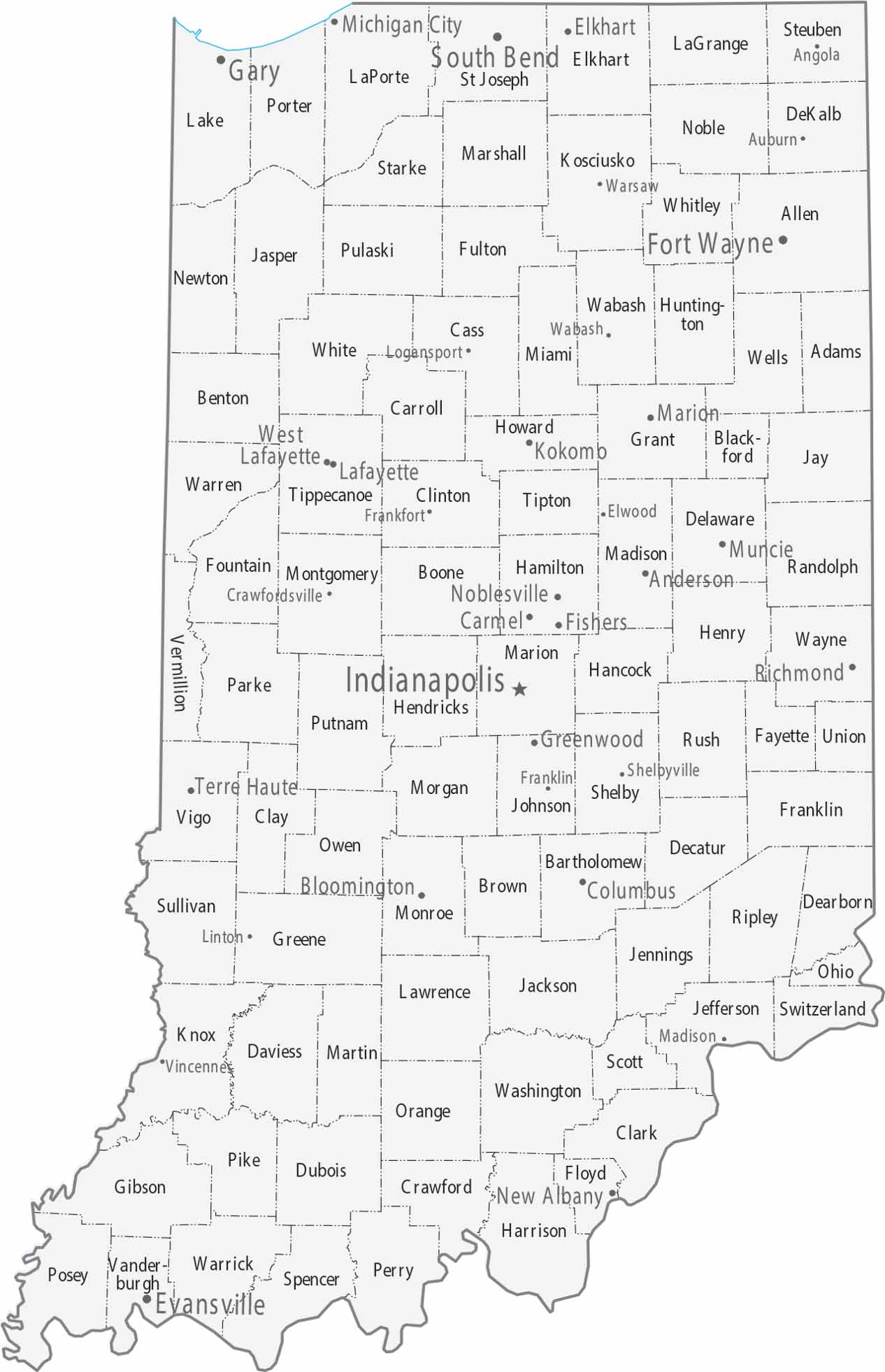
Our map of Indiana has Indianapolis sitting almost perfectly in the center. Fort Wayne anchors the northeast, Evansville the southwest, and South Bend the north near Michigan. Counties mostly form a regular grid, with cities spaced evenly throughout
Map Information
On the Map
|
Name |
Population 2024 |
Total Area (sq mi) |
FIPS Code |
|
Adams County |
36,584 |
340 |
18-001 |
|
Allen County |
399,295 |
660 |
18-003 |
|
Bartholomew County |
84,741 |
409.5 |
18-005 |
|
Benton County |
8,853 |
406.5 |
18-007 |
|
Blackford County |
11,816 |
165.6 |
18-009 |
|
Boone County |
78,773 |
423.2 |
18-011 |
|
Brown County |
15,650 |
316.6 |
18-013 |
|
Carroll County |
20,747 |
375 |
18-015 |
|
Cass County |
37,559 |
414.8 |
18-017 |
|
Clark County |
127,479 |
376.4 |
18-019 |
|
Clay County |
26,424 |
360.3 |
18-021 |
|
Clinton County |
32,895 |
405.2 |
18-023 |
|
Crawford County |
10,523 |
308.7 |
18-025 |
|
Daviess County |
34,097 |
436.9 |
18-027 |
|
Dearborn County |
51,435 |
307.4 |
18-029 |
|
Decatur County |
26,421 |
373.3 |
18-031 |
|
DeKalb County |
44,330 |
363.9 |
18-033 |
|
Delaware County |
112,951 |
395.9 |
18-035 |
|
Dubois County |
43,629 |
435.3 |
18-037 |
|
Elkhart County |
207,436 |
468 |
18-039 |
|
Fayette County |
23,335 |
215.2 |
18-041 |
|
Floyd County |
81,931 |
149 |
18-043 |
|
Fountain County |
16,833 |
397.9 |
18-045 |
|
Franklin County |
23,136 |
391 |
18-047 |
|
Fulton County |
20,004 |
371.3 |
18-049 |
|
Gibson County |
33,038 |
499.2 |
18-051 |
|
Grant County |
66,458 |
414.9 |
18-053 |
|
Greene County |
31,219 |
545.9 |
18-055 |
|
Hamilton County |
379,704 |
402.4 |
18-057 |
|
Hancock County |
88,810 |
307 |
18-059 |
|
Harrison County |
39,978 |
486.5 |
18-061 |
|
Hendricks County |
190,629 |
408.8 |
18-063 |
|
Henry County |
49,081 |
394.8 |
18-065 |
|
Howard County |
84,082 |
293.9 |
18-067 |
|
Huntington County |
36,944 |
387.7 |
18-069 |
|
Jackson County |
47,420 |
513.9 |
18-071 |
|
Jasper County |
33,387 |
561.4 |
18-073 |
|
Jay County |
20,164 |
384.1 |
18-075 |
|
Jefferson County |
32,921 |
362.9 |
18-077 |
|
Jennings County |
27,634 |
378.3 |
18-079 |
|
Johnson County |
170,614 |
321.8 |
18-081 |
|
Knox County |
35,872 |
524 |
18-083 |
|
Kosciusko County |
80,669 |
554.4 |
18-085 |
|
LaGrange County |
41,122 |
386.7 |
18-087 |
|
Lake County |
502,955 |
626.6 |
18-089 |
|
LaPorte County |
111,348 |
613.3 |
18-091 |
|
Lawrence County |
45,192 |
451.9 |
18-093 |
|
Madison County |
134,222 |
452.9 |
18-095 |
|
Marion County |
981,628 |
403 |
18-097 |
|
Marshall County |
46,464 |
449.7 |
18-099 |
|
Martin County |
9,864 |
340.4 |
18-101 |
|
Miami County |
35,613 |
377.4 |
18-103 |
|
Monroe County |
140,702 |
411.3 |
18-105 |
|
Montgomery County |
38,633 |
505.4 |
18-107 |
|
Morgan County |
73,825 |
409.4 |
18-109 |
|
Newton County |
14,131 |
403.4 |
18-111 |
|
Noble County |
47,811 |
417.4 |
18-113 |
|
Ohio County |
5,996 |
87.4 |
18-115 |
|
Orange County |
19,824 |
408.2 |
18-117 |
|
Owen County |
21,851 |
387.8 |
18-119 |
|
Parke County |
16,508 |
450 |
18-121 |
|
Perry County |
19,320 |
386.3 |
18-123 |
|
Pike County |
12,116 |
341.1 |
18-125 |
|
Porter County |
175,860 |
521.8 |
18-127 |
|
Posey County |
25,067 |
419.3 |
18-129 |
|
Pulaski County |
12,421 |
434.5 |
18-131 |
|
Putnam County |
37,804 |
482.7 |
18-133 |
|
Randolph County |
24,337 |
453.3 |
18-135 |
|
Ripley County |
29,214 |
448.1 |
18-137 |
|
Rush County |
16,759 |
408.5 |
18-139 |
|
St. Joseph County |
273,744 |
461.4 |
18-141 |
|
Scott County |
24,751 |
192.7 |
18-143 |
|
Shelby County |
45,654 |
412.8 |
18-145 |
|
Spencer County |
20,192 |
401.4 |
18-147 |
|
Starke County |
23,463 |
312.2 |
18-149 |
|
Steuben County |
34,862 |
322.5 |
18-151 |
|
Sullivan County |
20,768 |
454.1 |
18-153 |
|
Switzerland County |
9,988 |
223.4 |
18-155 |
|
Tippecanoe County |
191,650 |
503.2 |
18-157 |
|
Tipton County |
15,324 |
260.6 |
18-159 |
|
Union County |
6,884 |
165.2 |
18-161 |
|
Vanderburgh County |
180,387 |
236.6 |
18-163 |
|
Vermillion County |
15,516 |
259.9 |
18-165 |
|
Vigo County |
106,166 |
410.4 |
18-167 |
|
Wabash County |
30,777 |
421 |
18-169 |
|
Warren County |
8,451 |
366.4 |
18-171 |
|
Warrick County |
66,339 |
391 |
18-173 |
|
Washington County |
28,345 |
516.6 |
18-175 |
|
Wayne County |
66,410 |
404.3 |
18-177 |
|
Wells County |
28,798 |
370.2 |
18-179 |
|
White County |
24,833 |
508.7 |
18-181 |
|
Whitley County |
34,885 |
337.9 |
18-183 |
Counties and Cities Maps
Select any state map below to view its counties and cities map.


Indiana State Maps
Study about Indiana with our map collection


