Home » State Maps » Arkansas Population Map

Arkansas Population Map

Arkansas Population Density Map

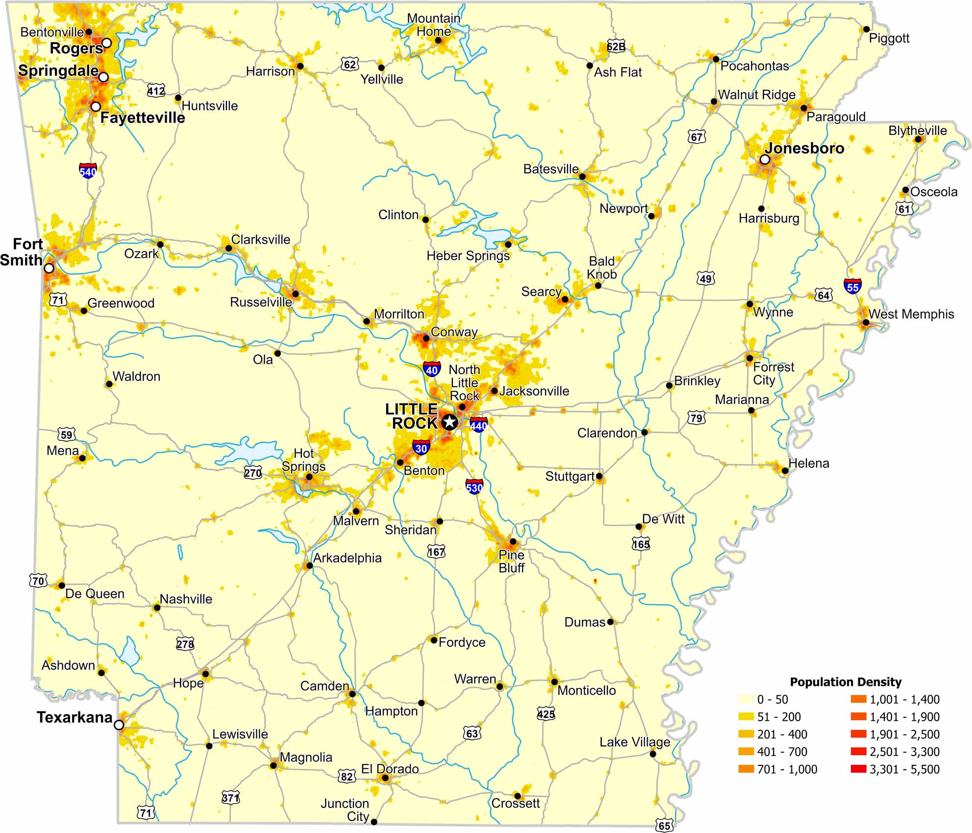
Population density in Arkansas increases near major cities like Little Rock. Our map also shows large rural regions with far fewer residents.

Map Information

  • Population Density Map of Arkansas
  • Data provided by NASA SEDAC Gridded Population of the World
  • Free for personal and commercial purpose. Attribution is required. How to attribute?

On the Map

Arkansas Location Map
State Capital: Little Rock Major Cities: Fayetteville, Fort Smith, Jonesboro, Rogers, Springdale, Texarkana Cities and Towns: Arkadelphia, Ash Flat, Ashdown, Bald Knob, Batesville, Benton, Bentonville, Blytheville, Brinkley, Camden, Clarendon, Clarksville, Clinton, Conway, Crossett, De Queen, De Witt, Dumas, El Dorado, Fordyce, Forrest City, Greenwood, Hampton, Harrisburg, Harrison, Heber Springs, Helena, Hope, Hot Springs, Huntsville, Jacksonville, Junction City, Lake Village, Lewisville, Magnolia, Malvern, Marianna, Mena, Monticello, Morrilton, Mountain Home, Nashville, Newport, North Little Rock, Ola, Osceola, Ozark, Paragould, Piggott, Pine Bluff, Pocahontas, Russelville, Searcy, Sheridan, Stuttgart, Waldron, Walnut Ridge, Warren, West Memphis, Wynne, Yellville Interstate Highways: I-30, I-40, I-55, I-430, I-440, I-530, I-540, I-630 US Routes: U.S. 49, U.S. 59, U.S. 61, U.S. 62, U.S. 62B, U.S. 63, U.S. 64, U.S. 65, U.S. 67, U.S. 70, U.S. 71, U.S. 79, U.S. 82, U.S. 165, U.S. 167, U.S. 270, U.S. 270B, U.S. 271, U.S. 278, U.S. 278B, U.S. 371, U.S. 412, U.S. 425

Leave a Reply

Your email address will not be published. Required fields are marked *