Alabama Counties and Cities Map
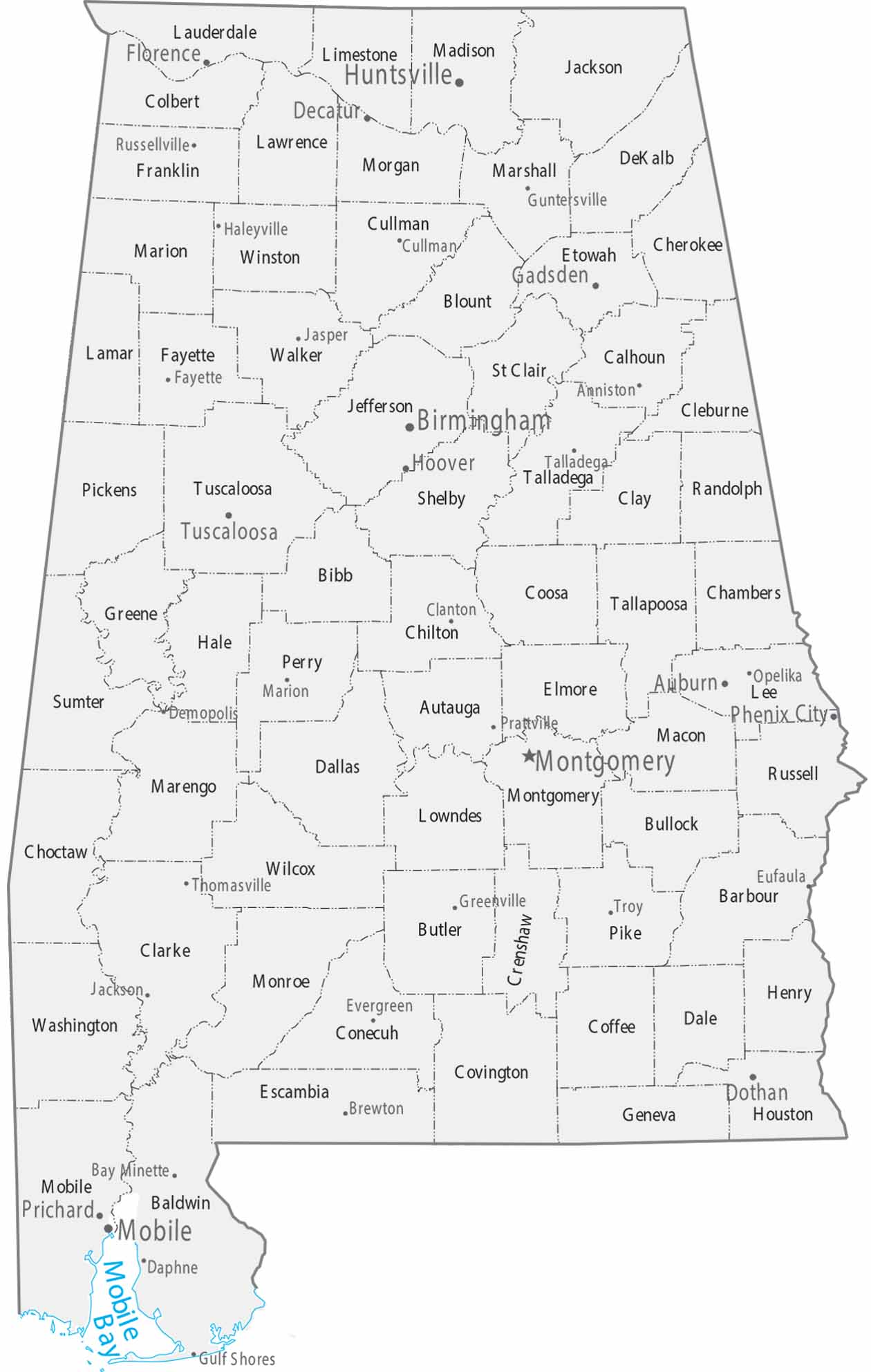
This map shows Alabama’s counties alongside major and minor cities. Population centers cluster along the Tennessee River in the north and around Birmingham in Jefferson County. Southern counties thin out toward the coastal plain near Mobile Bay.
Map Information
On the Map
Our table below provides you with population, area, and FIPS code for each county.
|
Name |
Population 2024 |
Total Area (sq mi) |
FIPS Code |
|
Autauga County |
61,464 |
604.4 |
01-001 |
|
Baldwin County |
261,608 |
2,027.30 |
01-003 |
|
Barbour County |
24,358 |
904.5 |
01-005 |
|
Bibb County |
22,258 |
626.2 |
01-007 |
|
Blount County |
60,163 |
650.6 |
01-009 |
|
Bullock County |
9,901 |
625.1 |
01-011 |
|
Butler County |
18,256 |
777.9 |
01-013 |
|
Calhoun County |
116,427 |
612.3 |
01-015 |
|
Chambers County |
33,813 |
603.1 |
01-017 |
|
Cherokee County |
26,138 |
600 |
01-019 |
|
Chilton County |
47,262 |
700.8 |
01-021 |
|
Choctaw County |
12,052 |
920.9 |
01-023 |
|
Clarke County |
22,142 |
1,252.60 |
01-025 |
|
Clay County |
14,239 |
606 |
01-027 |
|
Cleburne County |
15,905 |
561 |
01-029 |
|
Coffee County |
56,358 |
680.5 |
01-031 |
|
Colbert County |
58,785 |
623.5 |
01-033 |
|
Conecuh County |
11,109 |
852.8 |
01-035 |
|
Coosa County |
10,291 |
666.3 |
01-037 |
|
Covington County |
37,748 |
1,043.80 |
01-039 |
|
Crenshaw County |
13,114 |
610.9 |
01-041 |
|
Cullman County |
92,604 |
755 |
01-043 |
|
Dale County |
50,067 |
562.7 |
01-045 |
|
Dallas County |
35,545 |
993.8 |
01-047 |
|
DeKalb County |
73,122 |
778.7 |
01-049 |
|
Elmore County |
91,042 |
657 |
01-051 |
|
Escambia County |
36,630 |
953.1 |
01-053 |
|
Etowah County |
103,207 |
548.6 |
01-055 |
|
Fayette County |
15,863 |
629.4 |
01-057 |
|
Franklin County |
31,874 |
646.5 |
01-059 |
|
Geneva County |
27,259 |
578.9 |
01-061 |
|
Greene County |
7,127 |
659.9 |
01-063 |
|
Hale County |
15,116 |
656.5 |
01-065 |
|
Henry County |
18,141 |
568.3 |
01-067 |
|
Houston County |
109,366 |
581.7 |
01-069 |
|
Jackson County |
53,780 |
1,126.80 |
01-071 |
|
Jefferson County |
664,744 |
1,124.10 |
01-073 |
|
Lamar County |
13,543 |
605.5 |
01-075 |
|
Lauderdale County |
97,502 |
719.6 |
01-077 |
|
Lawrence County |
33,567 |
717.2 |
01-079 |
|
Lee County |
187,847 |
615.8 |
01-081 |
|
Limestone County |
118,942 |
607.2 |
01-083 |
|
Lowndes County |
9,485 |
725.1 |
01-085 |
|
Macon County |
18,159 |
613.2 |
01-087 |
|
Madison County |
423,355 |
812.7 |
01-089 |
|
Marengo County |
18,512 |
982.7 |
01-091 |
|
Marion County |
29,323 |
743.6 |
01-093 |
|
Marshall County |
102,156 |
623.2 |
01-095 |
|
Mobile County |
412,339 |
1,644.00 |
01-097 |
|
Monroe County |
19,057 |
1,034.40 |
01-099 |
|
Montgomery County |
225,894 |
799.9 |
01-101 |
|
Morgan County |
126,084 |
599 |
01-103 |
|
Perry County |
7,719 |
723.9 |
01-105 |
|
Pickens County |
18,508 |
890.1 |
01-107 |
|
Pike County |
33,124 |
673 |
01-109 |
|
Randolph County |
23,067 |
584.1 |
01-111 |
|
Russell County |
58,837 |
647.2 |
01-113 |
|
St. Clair County |
96,927 |
653.4 |
01-115 |
|
Shelby County |
235,969 |
809.5 |
01-117 |
|
Sumter County |
11,607 |
913.3 |
01-119 |
|
Talladega County |
81,375 |
760.3 |
01-121 |
|
Tallapoosa County |
40,699 |
766.2 |
01-123 |
|
Tuscaloosa County |
241,212 |
1,351.20 |
01-125 |
|
Walker County |
65,260 |
805.2 |
01-127 |
|
Washington County |
15,018 |
1,088.60 |
01-129 |
|
Wilcox County |
9,865 |
907.4 |
01-131 |
|
Winston County |
23,869 |
631.9 |
01-133 |
Counties and Cities Maps
Select any state map below to view its counties and cities map.


