Colorado National Parks and Forests Map
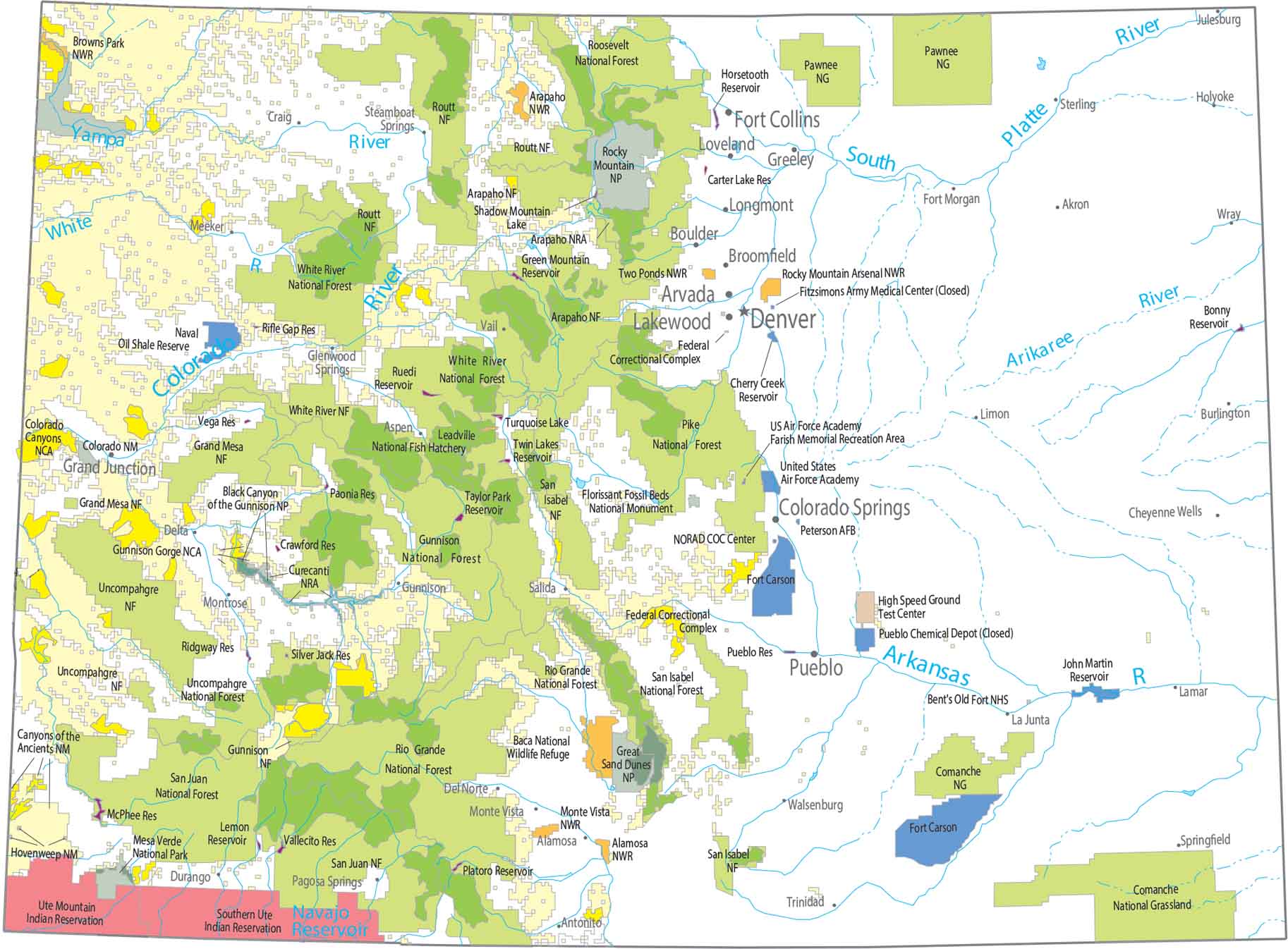
Everything clusters around height with Rocky Mountain National Park as the centerpiece. Forests stretch along the Rockies in long, narrow bands. Our map shows how little protection reaches the plains in the east.
Map Information
On the Map
Parks and Forests
National Parks (NP): Black Canyon of the Gunnison NP, Great Sand Dunes NP, Mesa Verde NP, Rocky Mountain NP National Forests (NF): Arapaho NF, Arapaho NF, Grand Mesa NF, Grand Mesa NF, Gunnison NF, Manti-La Sal NF, Medicine Bow NF, Pike National Forest, Rio Grande NF, Rio Grande NF, Roosevelt NF, Routt NF, San Isabel NF, San Juan NF, Uncompahgre NF, Uncompahgre NF, White River NF National Wildlife Refuges (NWR): Alamosa NWR, Arapaho NWR, Baca NWR, Browns Park NWR, Monte Vista NWR, Rocky Mountain Arsenal NWR, Two Ponds NWR National Monuments (NM): Canyons of the Ancients NM, Colorado NM, Dinosaur NM, Florissant Fossil Beds NM, Hovenweep NM National Conservation Areas (NCA): Gunnison Gorge NCA, McInnis Canyons NCA National Recreational Areas (NRA): Arapaho NRA, Curecanti NRA, Farish Memorial Recreation Area Other Conservation Areas: Bent’s Old Fort NHS, Comanche National Grassland, Leadville National Fish Hatchery, Pawnee National GrasslandLand Information
State Capital: Denver Cities and Towns: Akron, Alamosa, Antonito, Arvada, Aspen, Burlington, Boulder, Broomfield, Cheyenne Wells, Colorado Springs, Craig, Del Norte, Delta, Durango, Fort Collins, Fort Morgan, Glenwood Springs, Grand Junction, Greeley, Gunnison, Holyoke, Julesburg, La Junta, Lakewood, Lamar, Limon, Longmont, Loveland, Meeker, Monte Vista, Montrose, Pagosa Springs, Pueblo, Salida, Springfield, Steamboat Springs, Sterling, Trinidad, Walsenburg Rivers and Streams: Arikaree River, Arkansas River, Colorado River, South Platte River, White River, Yampa River Lakes and Reservoirs: Bonny Reservoir, Carter Lake Reservoir, Cherry Creek Reservoir, Crawford Reservoir, Green Mountain Reservoir, Horsetooth Reservoir, John Martin Reservoir, Lemon Reservoir, McPhee Reservoir, Paonia Reservoir, Platoro Reservoir, Ridgway Reservoir, Rifle Gap Reservoir, Ruedi Reservoir, Shadow Mountain Lake, Silver Jack Reservoir, Taylor Park Reservoir, Turquoise Lake, Twin Lakes Reservoir, Vallecito Reservoir, Vega Reservoir Indian Reserves (IR): Southern Ute IR, Ute Mountain IR Army, Naval and Military: Fitzsimons Army Medical Center (Closed), Fort Carson, High Speed Ground Test Center, Naval Oil Shale Reserve, Peterson AFB NORAD COC Center, Pueblo Chemical Depot (Closed), Pueblo Res Federal Correctional Complex, United States Air Force Academy, US Air Force AcademyColorado State Maps
Browse Colorado with our detailed state maps


