Home » State Maps » Map of Wisconsin

Map of Wisconsin

Wisconsin Map

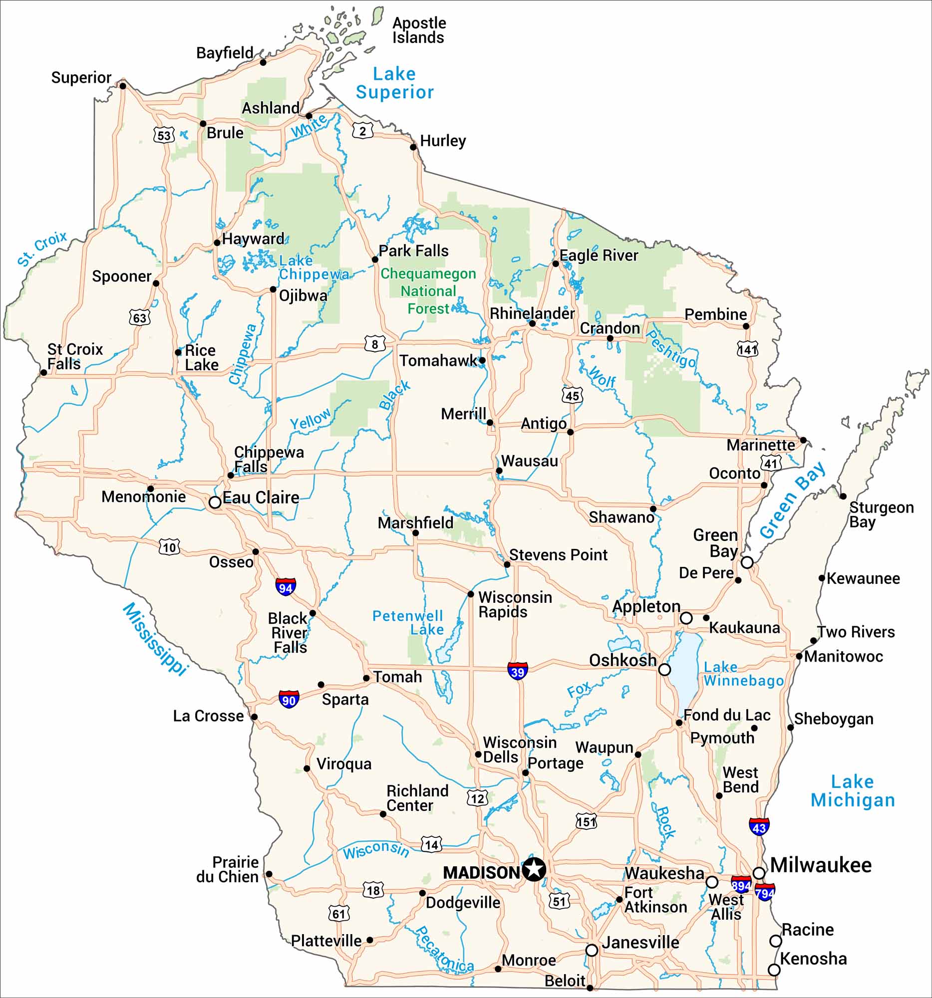
Get to know Wisconsin with our road map. It shows highways, rivers, and lakes. The Great Lakes border it on two sides, with farmland and forests in between. Cities like Milwaukee and Madison stand out as major cities.

Map Information

  • State of Wisconsin
  • Road Map of Wisconsin
  • Free for personal and commercial purpose. Attribution is required. How to attribute?

On the Map

Wisconsin Location Map
State Capital: Madison Major Cities: Appleton, Green Bay, Janesville, Milwaukee, Oshkosh Cities and Towns: Antigo, Ashland, Bayfield, Beloit, Black River Falls, Brule, Chippewa Falls, Crandon, De Pere, Dodgeville, Eagle River, Eau Claire, Fond du Lac, Fort Atkinson, Hayward, Hurley, Kaukauna, Kenosha, Kewaunee, La Crosse, Manitowoc, Marinette, Marshfield, Menomonie, Merrill, Monroe, Oconto, Osseo, Park Falls, Pembine, Platteville, Portage, Prairie du Chien, Pymouth, Racine, Rhinelander, Rice Lake, Richland Center, Shawano, Sheboygan, Sparta, Spooner, St Croix Falls, Stevens Point, Sturgeon Bay, Superior, Tomah, Tomahawk, Two Rivers, Viroqua, Waukesha, Waupun, Wausau, West Allis, West Bend, Wisconsin Dells, Wisconsin Rapids Interstate Highways: I-39, I-43, I-90, I-94, I-794, I-894 US Routes: US-2, US-8, US-10, US-12, US-14, US-18, US-41, US-45, US-51, US-53, US-61, US-63, US-141, US-151 Lakes and Reservoirs: Lake Chippewa, Lake Michigan, Lake Superior, Lake Winnebago, Petenwell Lake Rivers and Streams: Black River, Chippewa River, Mississippi River, Pecatonica River, Peshtigo River, Rock River, St. Croix River, White River, Wisconsin River, Wolf River, Yellow River National Parks and Forests: Chequamegon National Forest

City Maps of Wisconsin

See our Wisconsin maps designed for clarity.

References

  1. Government Website of Wisconsin
  2. Wisconsin in Google Maps

Leave a Reply

Your email address will not be published. Required fields are marked *