United States Lakes and Rivers Map
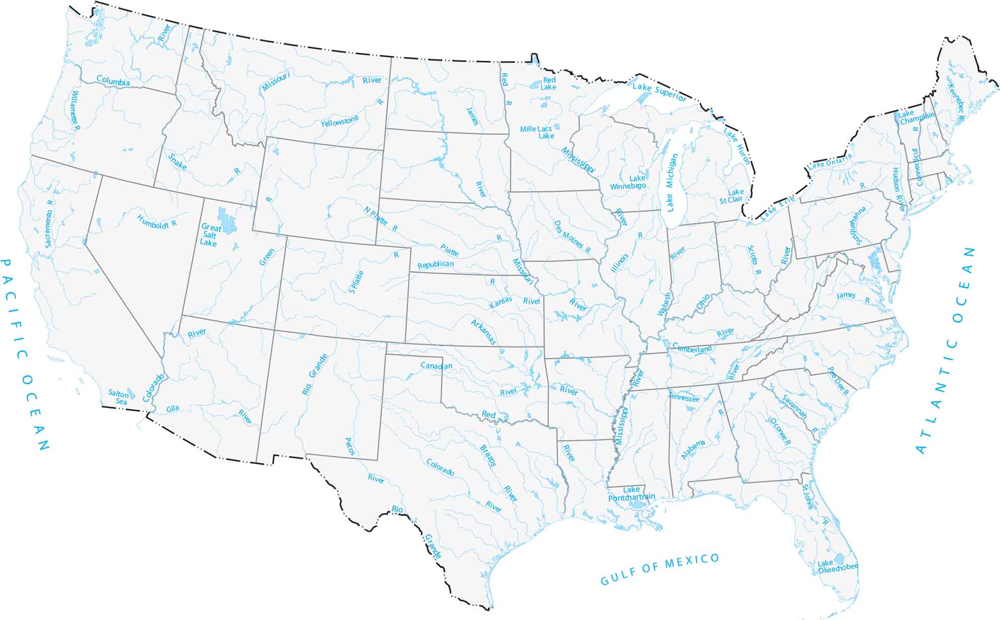
Our map of America’s lakes and rivers shows the major waterways that define the country’s landscape. You’ll spot the Mississippi River in the center, the Great Lakes in the north, and the Colorado River cutting through the West.
Map Information
Lakes and Rivers State Maps
Select any state map below to view its lakes and rivers map.


On the Map
Oceans: Pacific Ocean, Atlantic OceanGreat Lakes: Lake Michigan, Lake Ontario, Lake Erie, Lake Michigan, Lake Superior
|
State |
Major Rivers and Water Bodies |
|
Alabama |
Alabama R, Tennessee R |
|
Arizona |
Colorado R, Gila R |
|
Arkansas |
Arkansas R, Mississippi R, Red R, White R |
|
California |
Sacramento R, Colorado R, Salton Sea |
|
Colorado |
Colorado R, Rio Grande, Arkansas R, S Platte R |
|
Connecticut |
Connecticut R |
|
Florida |
St. Johns R, L. Okeechobee |
|
Georgia |
Savannah R, Oconee R |
|
Idaho |
Snake R |
|
Illinois |
Illinois R, Mississippi R, Ohio R, Wabash R |
|
Indiana |
Wabash R, Ohio R |
|
Iowa |
Des Moines R, Mississippi R, Missouri R |
|
Kansas |
Kansas R, Arkansas R, Republican R |
|
Kentucky |
Ohio R, Cumberland R, Tennessee R, Mississippi R |
|
Louisiana |
Mississippi R, Red R, Lake Pontchartrain |
|
Maine |
Kennebec R, Penobscot R |
|
Maryland |
Potomac R |
|
Massachusetts |
Connecticut R |
|
Michigan |
Lake Superior, Lake Michigan, Lake Huron, Lake St. Clair, Lake Erie |
|
Minnesota |
Mississippi R, Red R, Mille Lacs Lake, Lake Superior |
|
Mississippi |
Mississippi R |
|
Missouri |
Missouri R, Mississippi R |
|
Montana |
Missouri R, Yellowstone R |
|
Nebraska |
Platte R, N Platte R, Missouri R |
|
Nevada |
Humboldt R |
|
New Jersey |
Hudson R, Delaware R |
|
New Mexico |
Rio Grande, Pecos R, Canadian R |
|
New York |
Hudson R, Lake Champlain |
|
North Carolina |
Roanoke R |
|
North Dakota |
Missouri R, James R, Red R |
|
Ohio |
Scioto R, Ohio R, Lake Erie |
|
Oklahoma |
Arkansas R, Canadian R, Red R |
|
Oregon |
Columbia R, Willamette R |
|
Pennsylvania |
Susquehanna R, Delaware R |
|
South Carolina |
Pee Dee R, Savannah R |
|
South Dakota |
Missouri R, James R |
|
Tennessee |
Tennessee R, Cumberland R, Mississippi R |
|
Texas |
Rio Grande, Pecos R, Colorado R, Brazos R, Red R, Canadian R |
|
Utah |
Green R, Great Salt Lake |
|
Vermont |
Lake Champlain |
|
Virginia |
James R, Potomac R |
|
Washington |
Columbia R, Snake R |
|
West Virginia |
Ohio R, Potomac R |
|
Wisconsin |
Mississippi R, Lake Winnebago |
|
Wyoming |
Yellowstone R, Snake R, Green R, N Platte R |
Country Maps
Explore the geography that defines this nation.


