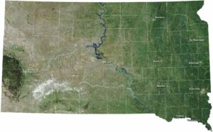
South Dakota Precipitation Map

Our precipitation map of South Dakota shows the Black Hills standing out as the wettest spot in an otherwise dry state. The plains to the east and west of those hills sit in rain shadows. The southeast corner also receives a fair amount of rainfall as well.
Map Information
State Precipitation Maps
Select any state map below to view its precipitation map.


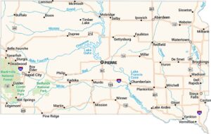
South Dakota State Maps
View maps from the prairies to the Black Hills.