New York Counties and Cities Map
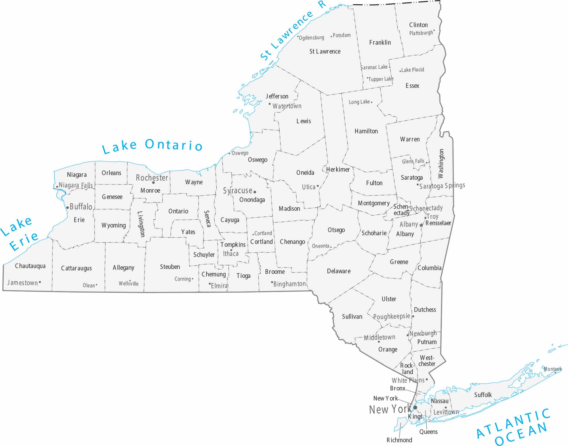
Spanning from the Atlantic to the Great Lakes, our map of New York identifies 62 counties. New York City anchors the southeast, but the state is governed from Albany. This capital city is located further north along the Hudson River.
Map Information
On the Map
|
Name |
Population 2024 |
Total Area (sq mi) |
FIPS Code |
|
Albany County |
319,964 |
533.3 |
36-001 |
|
Allegany County |
47,299 |
1,034.40 |
36-003 |
|
Bronx County |
1,384,724 |
57.4 |
36-005 |
|
Broome County |
196,397 |
715.5 |
36-007 |
|
Cattaraugus County |
75,475 |
1,322.50 |
36-009 |
|
Cayuga County |
74,567 |
863.7 |
36-011 |
|
Chautauqua County |
124,105 |
1,500.20 |
36-013 |
|
Chemung County |
81,115 |
410.8 |
36-015 |
|
Chenango County |
45,776 |
898.6 |
36-017 |
|
Clinton County |
77,871 |
1,117.50 |
36-019 |
|
Columbia County |
60,299 |
648.2 |
36-021 |
|
Cortland County |
45,945 |
501.5 |
36-023 |
|
Delaware County |
44,191 |
1,467.40 |
36-025 |
|
Dutchess County |
299,963 |
825.3 |
36-027 |
|
Erie County |
950,602 |
1,226.80 |
36-029 |
|
Essex County |
36,744 |
1,916.30 |
36-031 |
|
Franklin County |
47,086 |
1,697.40 |
36-033 |
|
Fulton County |
52,073 |
532.9 |
36-035 |
|
Genesee County |
57,604 |
495.3 |
36-037 |
|
Greene County |
46,903 |
658 |
36-039 |
|
Hamilton County |
5,082 |
1,807.80 |
36-041 |
|
Herkimer County |
59,585 |
1,458.00 |
36-043 |
|
Jefferson County |
113,140 |
1,857.30 |
36-045 |
|
Kings County |
2,617,631 |
96.8 |
36-047 |
|
Lewis County |
26,570 |
1,289.90 |
36-049 |
|
Livingston County |
61,561 |
640.3 |
36-051 |
|
Madison County |
67,072 |
661.3 |
36-053 |
|
Monroe County |
752,202 |
1,366.70 |
36-055 |
|
Montgomery County |
49,648 |
410.3 |
36-057 |
|
Nassau County |
1,392,438 |
453.5 |
36-059 |
|
New York County |
1,660,664 |
33.7 |
36-061 |
|
Niagara County |
209,570 |
1,139.70 |
36-063 |
|
Oneida County |
228,347 |
1,257.60 |
36-065 |
|
Onondaga County |
469,812 |
805.6 |
36-067 |
|
Ontario County |
113,012 |
662.5 |
36-069 |
|
Orange County |
411,767 |
838.6 |
36-071 |
|
Orleans County |
39,686 |
817.4 |
36-073 |
|
Oswego County |
118,305 |
1,312.10 |
36-075 |
|
Otsego County |
60,524 |
1,015.80 |
36-077 |
|
Putnam County |
98,409 |
246.2 |
36-079 |
|
Queens County |
2,316,841 |
178 |
36-081 |
|
Rensselaer County |
160,749 |
665.4 |
36-083 |
|
Richmond County |
498,212 |
102.3 |
36-085 |
|
Rockland County |
348,144 |
199.3 |
36-087 |
|
St. Lawrence County |
106,198 |
2,821.30 |
36-089 |
|
Saratoga County |
240,360 |
843.8 |
36-091 |
|
Schenectady County |
162,261 |
209.4 |
36-093 |
|
Schoharie County |
30,151 |
626.3 |
36-095 |
|
Schuyler County |
17,121 |
342.3 |
36-097 |
|
Seneca County |
32,650 |
390.4 |
36-099 |
|
Steuben County |
92,015 |
1,404.10 |
36-101 |
|
Suffolk County |
1,535,909 |
2,373.10 |
36-103 |
|
Sullivan County |
80,450 |
996.7 |
36-105 |
|
Tioga County |
47,574 |
522.9 |
36-107 |
|
Tompkins County |
105,602 |
491.5 |
36-109 |
|
Ulster County |
182,977 |
1,160.80 |
36-111 |
|
Warren County |
65,288 |
931.6 |
36-113 |
|
Washington County |
59,839 |
845.9 |
36-115 |
|
Wayne County |
90,757 |
1,383.00 |
36-117 |
|
Westchester County |
1,006,447 |
500 |
36-119 |
|
Wyoming County |
39,588 |
596.3 |
36-121 |
|
Yates County |
24,387 |
375.8 |
36-123 |
Counties and Cities Maps
Select any state map below to view its counties and cities map.


