Home » State Maps » Missouri Population Map

Missouri Population Map

Missouri Population Density Map

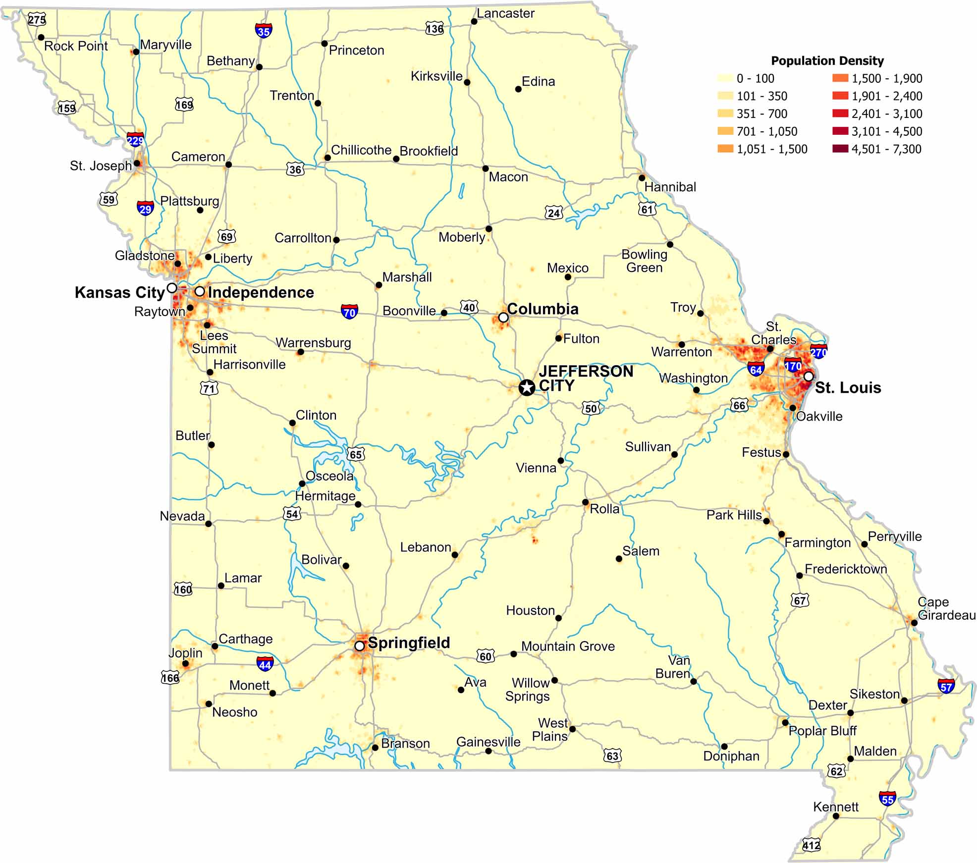
Population clusters around major metro areas like St. Louis and Kansas city. Central regions stay open with lower population density. Check out our population density map of Missouri to see where people reside in the state.

Map Information

  • Population Density Map of Missouri
  • Data provided by NASA SEDAC Gridded Population of the World
  • Free for personal and commercial purpose. Attribution is required. How to attribute?

On the Map

Missouri Location Map
State Capital: Jefferson City Major Cities: Independence, Kansas City, Springfield, St. Louis Cities and Towns: Ava, Belton, Bethany, Bolivar, Boonville, Bowling Green, Branson, Brookfield, Butler, Cameron, Cape Girardeau, Carrollton, Carthage, Chillicothe, Clinton, Columbia, Dexter, Doniphan, Edina, Farmington, Festus, Fredericktown, Fulton, Gainesville, Gladstone, Hannibal, Harrisonville, Hermitage, Houston, Joplin, Kennett, Kirksville, Lamar, Lancaster, Lebanon, Lees Summit, Liberty, Macon, Malden, Marshall, Maryville, Mexico, Moberly, Monett, Mountain Grove, Neosho, Nevada, Oakville, Osceola, Park Hills, Perryville, Plattsburg, Poplar Bluff, Princeton, Raytown, Rock Point, Rolla, Sikeston, St. Charles, St. Joseph, Sullivan, Trenton, Troy, Van Buren, Vienna, Warrensburg, Warrenton, Washington, West Plains, Willow Springs Interstate Highways: I-170, I-229, I-270, I-29, I-35, I-435, I-44, I-470, I-55, I-57, I-64, I-70 US Routes: US-136, US-159, US-160, US-166, US-169, US-24, US-275, US-36, US-40, US-412, US-50, US-54, US-59, US-60, US-61, US-62, US-63, US-65, US-66, US-67, US-71

Leave a Reply

Your email address will not be published. Required fields are marked *