Home » State Maps » Georgia Population Map

Georgia Population Map

Georgia Population Density Map

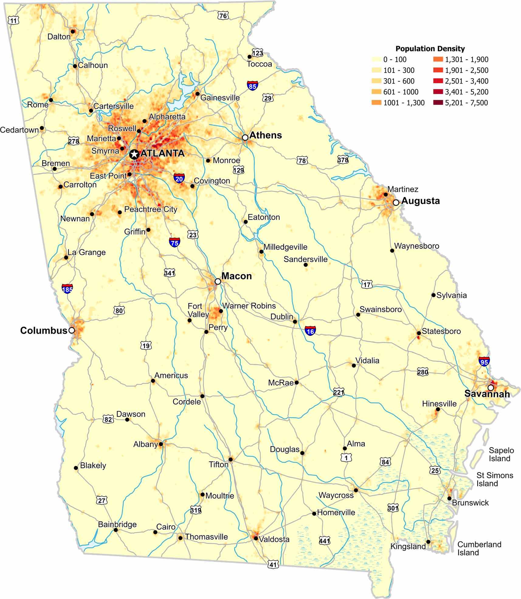
Atlanta defines Georgia’s population map as density spreads outward along its major interstates. Our population density map shows a clear break with southern regions remaining much quieter.

Map Information

  • Population Density Map of Georgia
  • Data provided by NASA SEDAC Gridded Population of the World
  • Free for personal and commercial purpose. Attribution is required. How to attribute?

On the Map

Georgia Location Map
State Capital: Atlanta Major Cities: Athens, Augusta, Columbus, Macon, Savannah Cities and Towns: Albany, Alma, Alpharetta, Americus, Bainbridge, Blakely, Bremen, Brunswick, Cairo, Calhoun, Carrolton, Cartersville, Cedartown, Cordele, Covington, Dalton, Dawson, Douglas, Dublin, East Point, Eatonton, Fort Valley, Gainesville, Griffin, Hinesville, Homerville, Kingsland, La Grange, Marietta, Martinez, McRae, Milledgeville, Monroe, Moultrie, Newnan, Peachtree City, Perry, Rome, Roswell, Sandersville, Smyrna, Statesboro, Swainsboro, Sylvania, Thomasville, Tifton, Toccoa, Valdosta, Vidalia, Warner Robins, Waycross, Waynesboro Interstate Highways: I-16, I-20, I-24, I-59, I-75, I-85, I-95, I-185, I-285, I-475, I-516, I-520, I-575, I-675, I-985 US Routes: US Hwy 1, US Hwy 11, US Hwy 17, US Hwy 19, US Hwy 23, US Hwy 25, US Hwy 27, US Hwy 29, US Hwy 41, US Hwy 76, US Hwy 78, US Hwy 80, US Hwy 82, US Hwy 84, US Hwy 123, US Hwy 129, US Hwy 221, US Hwy 278, US Hwy 280, US Hwy 301, US Hwy 319, US Hwy 341, US Hwy 378, US Hwy 411, US Hwy 441

Leave a Reply

Your email address will not be published. Required fields are marked *