US Election 1800 Map
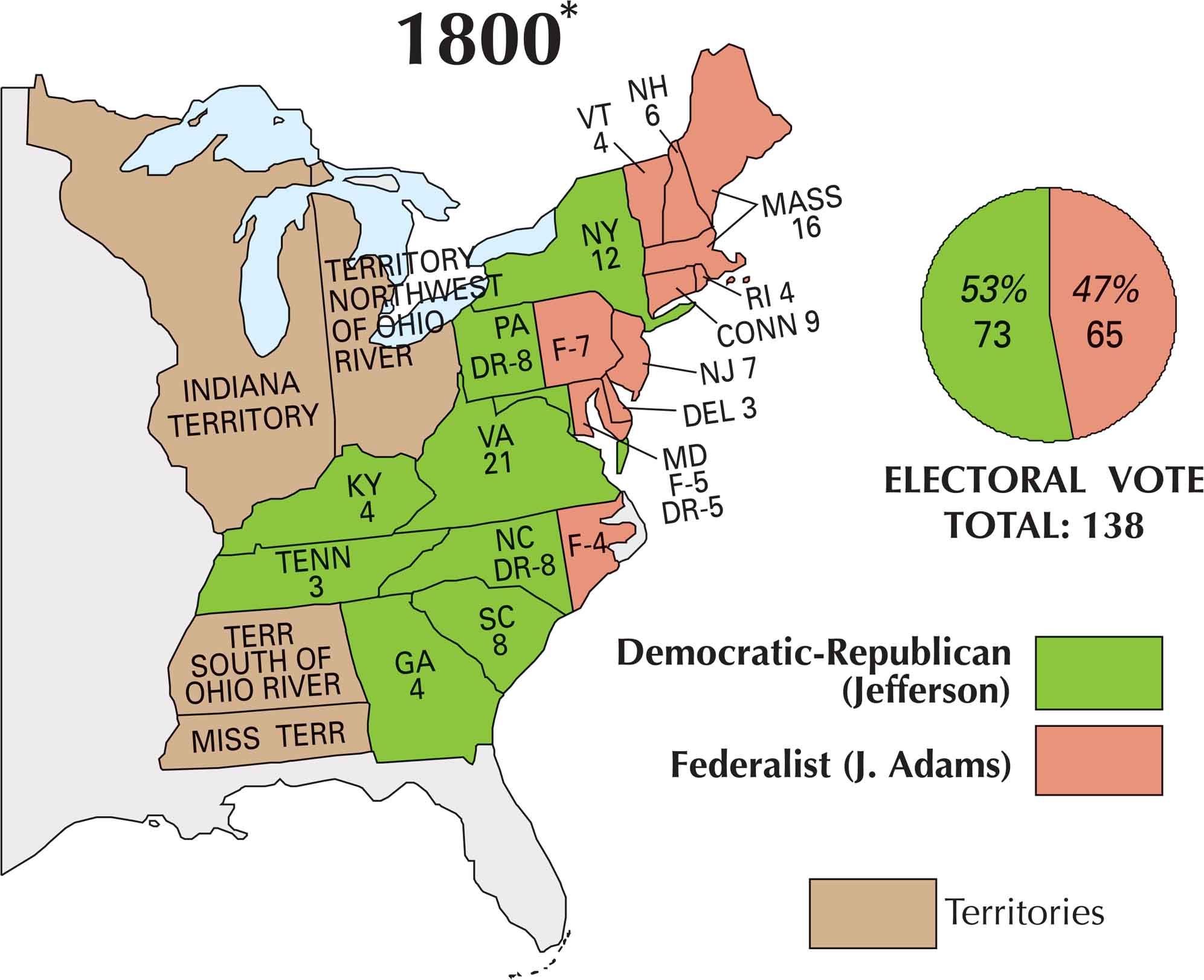
The election of 1800 was chaotic. Thomas Jefferson and Aaron Burr both ran as Democratic-Republicans. They tied but was finally handed to Jefferson for presidency. On this map, you can see how sharply the nation split. The Federalists, led by John Adams, held their strength in New England. Whereas Jefferson’s support came from the South and the expanding western states.
Map Information
US Election Maps
Click on a map below to check out the US election map and results.


On the Map
Here is the breakdown of states and their electoral votes, categorized by the Democratic-Republican (Jefferson) and Federalist (J. Adams) split:
States and Electoral Votes
|
State |
Total Votes |
Democratic-Republican (Jefferson) |
Federalist (Adams) |
|
Virginia |
21 |
21 |
0 |
|
Massachusetts |
16 |
0 |
16 |
|
Pennsylvania |
15 |
8 |
7 |
|
New York |
12 |
12 |
0 |
|
North Carolina |
12 |
8 |
4 |
|
Maryland |
10 |
5 |
5 |
|
Connecticut |
9 |
0 |
9 |
|
South Carolina |
8 |
8 |
0 |
|
New Jersey |
7 |
0 |
7 |
|
New Hampshire |
6 |
0 |
6 |
|
Georgia |
4 |
4 |
0 |
|
Kentucky |
4 |
4 |
0 |
|
Rhode Island |
4 |
0 |
4 |
|
Vermont |
4 |
0 |
4 |
|
Delaware |
3 |
0 |
3 |
|
Tennessee |
3 |
3 |
0 |
Election Summary
- Total Electoral Votes: 138
- The Winner: Thomas Jefferson (Democratic-Republican) with 73 votes (53%).
- Key Shifts: New York flipped entirely to the Democratic-Republicans compared to 1796, which was a decisive factor in the election.
- New Territories Noted: The map now includes the Indiana Territory and Miss Terr (Mississippi Territory) in addition to the others.