US Election 1832 Map
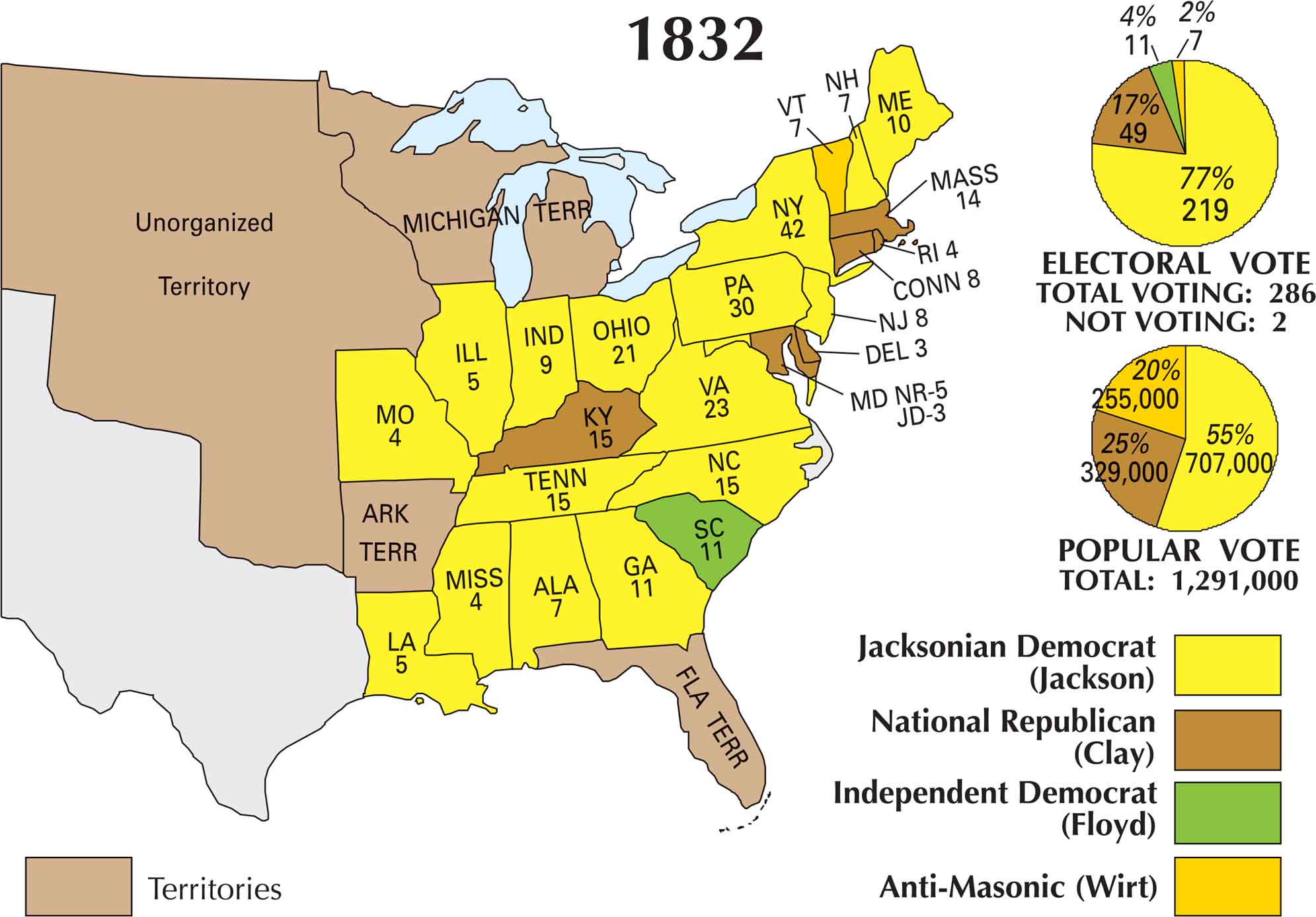
By 1832, Andrew Jackson was running for a second term. Jackson’s opponent was mainly Henry Clay who led the National Republican Party. This map shows Jackson sweeping most of the country, especially the South and West. But Clay held a few pockets in New England and the Mid-Atlantic.
Map Information
US Election Maps
Click on a map below to check out the US election map and results.

On the Map
The electoral votes were divided among four candidates: Jacksonian Democrat (Jackson), National Republican (Clay), Independent Democrat (Floyd), and Anti-Masonic (Wirt).
States and Electoral Votes
|
State |
Total Votes |
Jackson (JD) |
Clay (NR) |
Floyd (ID) |
Wirt (AM) |
|
New York |
42 |
42 |
0 |
0 |
0 |
|
Pennsylvania |
30 |
30 |
0 |
0 |
0 |
|
Virginia |
23 |
23 |
0 |
0 |
0 |
|
Ohio |
21 |
21 |
0 |
0 |
0 |
|
Kentucky |
15 |
0 |
15 |
0 |
0 |
|
North Carolina |
15 |
15 |
0 |
0 |
0 |
|
Tennessee |
15 |
15 |
0 |
0 |
0 |
|
Massachusetts |
14 |
0 |
14 |
0 |
0 |
|
Georgia |
11 |
11 |
0 |
0 |
0 |
|
South Carolina |
11 |
0 |
0 |
11 |
0 |
|
Maryland |
8 |
3 |
5 |
0 |
0 |
|
Maine |
10 |
10 |
0 |
0 |
0 |
|
Indiana |
9 |
9 |
0 |
0 |
0 |
|
Connecticut |
8 |
0 |
8 |
0 |
0 |
|
New Jersey |
8 |
8 |
0 |
0 |
0 |
|
New Hampshire |
7 |
7 |
0 |
0 |
0 |
|
Vermont |
7 |
0 |
0 |
0 |
7 |
|
Alabama |
7 |
7 |
0 |
0 |
0 |
|
Illinois |
5 |
5 |
0 |
0 |
0 |
|
Louisiana |
5 |
5 |
0 |
0 |
0 |
|
Mississippi |
4 |
4 |
0 |
0 |
0 |
|
Missouri |
4 |
4 |
0 |
0 |
0 |
|
Rhode Island |
4 |
0 |
4 |
0 |
0 |
|
Delaware |
3 |
0 |
3 |
0 |
0 |
Election Summary
- Total Voting: 286
- The Winner: Andrew Jackson (77%) with 219 votes.
- Popular Vote: Totaling 1,291,000. Jackson won with 55% (707,000 votes).
- Third-Party Influence: This election is notable for the presence of the Anti-Masonic Party, which won Vermont, and an Independent Democrat (Floyd) winning South Carolina.
- Growing Power: Several states saw significant increases in their electoral power. For example, New York jumped from 36 to 42 votes.