Home » State Maps » Map of Oklahoma

Map of Oklahoma

Oklahoma Map

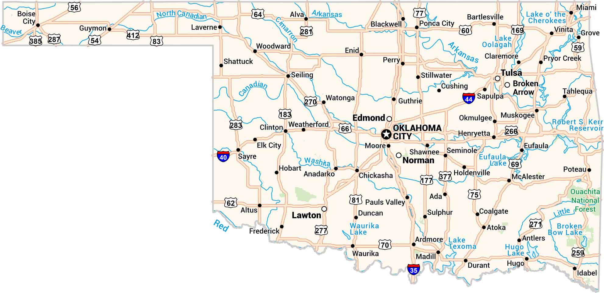
Oklahoma is wide horizontally with its mix of prairie, hills, and open sky. Our map displays its long highways past lakes and small towns. You can follow the Red River and any of its major lakes.

Map Information

  • State of Oklahoma
  • Road Map of Oklahoma
  • Free for personal and commercial purpose. Attribution is required. How to attribute?

On the Map

Oklahoma Location Map
State Capital: Oklahoma City Major Cities: Broken Arrow, Edmond, Lawton, Norman, Tulsa Cities and Towns: Ada, Altus, Alva, Anadarko, Antlers, Ardmore, Atoka, Bartlesville, Blackwell, Boise City, Chickasha, Claremore, Clinton, Coalgate, Cushing, Duncan, Durant, Elk City, Enid, Eufaula, Frederick, Grove, Guthrie, Guymon, Henryetta, Hobart, Holdenville, Hugo, Idabel, Laverne, Madill, McAlester, Miami, Moore, Muskogee, Okmulgee, Pauls Valley, Perry, Ponca City, Poteau, Pryor Creek, Sapulpa, Sayre, Seiling, Seminole, Shattuck, Shawnee, Stillwater, Sulphur, Tahlequah, Vinita, Watonga, Waurika, Weatherford, Woodward Interstate Highways: I-35, I-40, I-44 US Routes: US-54, US-56, US-59, US-60, US-62, US-64, US-66, US-69, US-70, US-75, US-77, US-81, US-83, US-169, US-177, US-183, US-259, US-266, US-270, US-271, US-277, US-281, US-283, US-287, US-377, US-385, US-412 Lakes and Reservoirs: Broken Bow Lake, Eufaula Lake, Hugo Lake, Lake o’ the Cherokees, Lake Oolagah, Lake Texoma, Robert S. Kerr Reservoir, Waurika Lake Rivers and Streams: Arkansas River, Beaver River, Canadian River, Cimarron River, Little River, North Canadian River, Red River, Washita River National Parks and Forests: Ouachita National Forest

City Maps of Oklahoma

Explore Oklahoma’s cities with our maps

References

  1. Government Website of Oklahoma
  2. Oklahoma in Google Maps

Leave a Reply

Your email address will not be published. Required fields are marked *