Home » State Maps » Pennsylvania Population Map

Pennsylvania Population Map

Pennsylvania Population Density Map

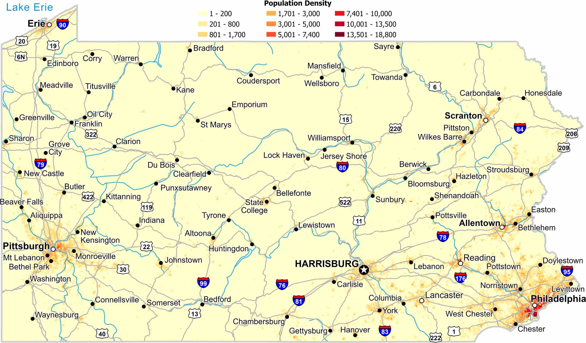
Population concentrates at the eastern and western ends of the state. The central mountains show much lower density. Also, forested ridges limit development.

Map Information

  • Population Density Map of Pennsylvania
  • Data provided by NASA SEDAC Gridded Population of the World
  • Free for personal and commercial purpose. Attribution is required. How to attribute?

On the Map

Pennsylvania Location Map
State Capital: Harrisburg Major Cities: Allentown, Erie, Philadelphia, Pittsburgh, Scranton Cities and Towns: Aliquippa, Altoona, Beaver Falls, Bedford, Bellefonte, Berwick, Bethel Park, Bethlehem, Bloomsburg, Bradford, Butler, Carbondale, Carlisle, Chambersburg, Chester, Clarion, Clearfield, Columbia, Connellsville, Corry, Coudersport, Doylestown, Du Bois, Easton, Edinboro, Emporium, Franklin, Gettysburg, Greenville, Grove City, Hanover, Hazleton, Honesdale, Huntingdon, Indiana, Jersey Shore, Johnstown, Kane, Kittanning, Lancaster, Lebanon, Levittown, Lewistown, Mansfield, Meadville, Monroe Ville, Mt Lebanon, New Castle, New Kensington, Norristown, Oil City, Pittston, Pottstown, Pottsville, Punxsutawney, Reading, Sayre, Sharon, Shenandoah, Somerset, State College, Stroudsburg, Sunbury, Titusville, Towanda, Tyrone, Warren, Washington, Waynesburg, Wellsboro, West Chester, Wilkes-Barre, Williamsport, York Interstate Highways: I-70, I-76, I-78, I-79, I-80, I-81, I-83, I-84, I-90, I-95, I-99, I-176, I-180, I-276, I-279, I-376, I-380, I-476 US Routes: US-1, US-6, US-6N, US-11, US-13, US-15, US-19, US-20, US-22, US-30, US-40, US-62, US-119, US-202, US-206, US-209, US-219, US-220, US-222, US-322, US-422, US-522

Leave a Reply

Your email address will not be published. Required fields are marked *