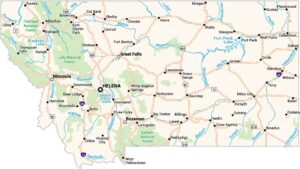
Montana Counties and Cities Map
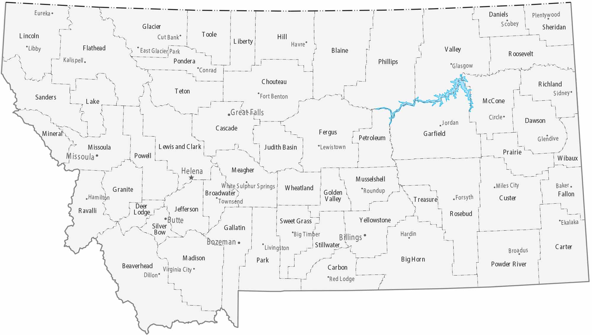
“Big Sky Country” is represented on our map by 56 massive counties. Our map is dominated by very large counties with few cities. Population centers are widely spaced and relatively small. Mountain ranges strongly influence county size and layout.
Map Information
On the Map
|
Name |
Population 2024 |
Total Area (sq mi) |
FIPS Code |
|
Beaverhead County |
10,006 |
5,572.90 |
30-001 |
|
Big Horn County |
12,796 |
5,016.10 |
30-003 |
|
Blaine County |
6,903 |
4,238.30 |
30-005 |
|
Broadwater County |
8,302 |
1,238.10 |
30-007 |
|
Carbon County |
11,498 |
2,061.40 |
30-009 |
|
Carter County |
1,399 |
3,348.00 |
30-011 |
|
Cascade County |
84,523 |
2,711.40 |
30-013 |
|
Chouteau County |
5,880 |
3,996.70 |
30-015 |
|
Custer County |
11,964 |
3,793.20 |
30-017 |
|
Daniels County |
1,625 |
1,426.40 |
30-019 |
|
Dawson County |
8,731 |
2,383.50 |
30-021 |
|
Deer Lodge County |
9,811 |
741.4 |
30-023 |
|
Fallon County |
2,946 |
1,622.80 |
30-025 |
|
Fergus County |
11,862 |
4,350.00 |
30-027 |
|
Flathead County |
114,527 |
5,256.00 |
30-029 |
|
Gallatin County |
126,984 |
2,633.80 |
30-031 |
|
Garfield County |
1,181 |
4,849.10 |
30-033 |
|
Glacier County |
13,503 |
3,035.90 |
30-035 |
|
Golden Valley County |
863 |
1,175.40 |
30-037 |
|
Granite County |
3,602 |
1,732.80 |
30-039 |
|
Hill County |
16,065 |
2,916.40 |
30-041 |
|
Jefferson County |
13,304 |
1,659.40 |
30-043 |
|
Judith Basin County |
2,111 |
1,870.50 |
30-045 |
|
Lake County |
33,403 |
1,654.00 |
30-047 |
|
Lewis and Clark County |
75,129 |
3,497.50 |
30-049 |
|
Liberty County |
1,934 |
1,447.10 |
30-051 |
|
Lincoln County |
22,184 |
3,674.90 |
30-053 |
|
McCone County |
1,717 |
2,682.00 |
30-055 |
|
Madison County |
9,753 |
3,603.50 |
30-057 |
|
Meagher County |
2,065 |
2,394.70 |
30-059 |
|
Mineral County |
5,195 |
1,223.40 |
30-061 |
|
Missoula County |
122,546 |
2,617.90 |
30-063 |
|
Musselshell County |
5,452 |
1,871.70 |
30-065 |
|
Park County |
18,074 |
2,813.20 |
30-067 |
|
Petroleum County |
525 |
1,674.50 |
30-069 |
|
Phillips County |
4,214 |
5,212.10 |
30-071 |
|
Pondera County |
6,078 |
1,641.50 |
30-073 |
|
Powder River County |
1,734 |
3,298.80 |
30-075 |
|
Powell County |
7,120 |
2,332.30 |
30-077 |
|
Prairie County |
1,112 |
1,742.40 |
30-079 |
|
Ravalli County |
48,187 |
2,400.30 |
30-081 |
|
Richland County |
11,028 |
2,103.30 |
30-083 |
|
Roosevelt County |
10,197 |
2,369.20 |
30-085 |
|
Rosebud County |
8,194 |
5,025.20 |
30-087 |
|
Sanders County |
13,895 |
2,789.90 |
30-089 |
|
Sheridan County |
3,448 |
1,704.80 |
30-091 |
|
Silver Bow County |
36,134 |
718.6 |
30-093 |
|
Stillwater County |
9,450 |
1,805.90 |
30-095 |
|
Sweet Grass County |
3,757 |
1,862.30 |
30-097 |
|
Teton County |
6,444 |
2,291.90 |
30-099 |
|
Toole County |
5,153 |
1,945.10 |
30-101 |
|
Treasure County |
739 |
984.4 |
30-103 |
|
Valley County |
7,434 |
5,061.80 |
30-105 |
|
Wheatland County |
2,058 |
1,427.50 |
30-107 |
|
Wibaux County |
911 |
889.3 |
30-109 |
|
Yellowstone County |
171,583 |
2,648.90 |
30-111 |
Counties and Cities Maps
Select any state map below to view its counties and cities map.


Montana State Maps
Wander through this wide-open state with our map collection.