US Election 1816 Map
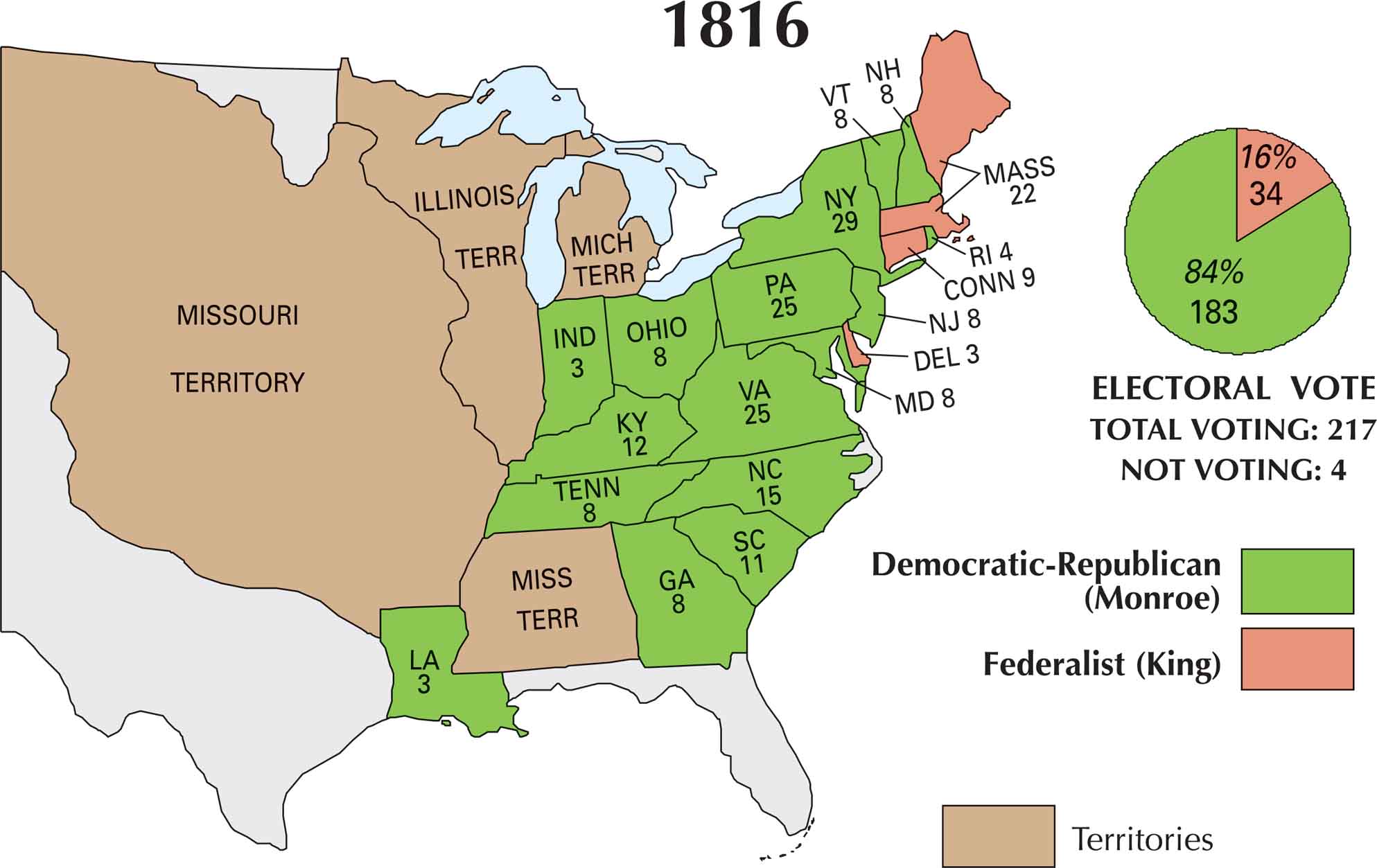
By 1816, the political landscape had quieted down. The Federalist Party was collapsing and James Monroe was the Democratic-Republican candidate that coasted to victory. With the War of 1812 over, voters were ready for stability. On our 1816 US election map, Monroe nearly sweeps it all. Only Massachusetts, Connecticut, Rhode Island and Delaware stuck with the fading Federalists.
Map Information
US Election Maps
Click on a map below to check out the US election map and results.


On the Map
Here is the list of states and their electoral votes for James Monroe (Democratic-Republican) and Rufus King (Federalist):
States and Electoral Votes
|
State |
Total Votes |
Monroe (DR) |
King (F) |
|
New York |
29 |
29 |
0 |
|
Pennsylvania |
25 |
25 |
0 |
|
Virginia |
25 |
25 |
0 |
|
Massachusetts |
22 |
0 |
22 |
|
North Carolina |
15 |
15 |
0 |
|
Kentucky |
12 |
12 |
0 |
|
South Carolina |
11 |
11 |
0 |
|
Connecticut |
9 |
0 |
9 |
|
Maryland |
8 |
8 |
0 |
|
New Jersey |
8 |
8 |
0 |
|
New Hampshire |
8 |
8 |
0 |
|
Vermont |
8 |
8 |
0 |
|
Georgia |
8 |
8 |
0 |
|
Tennessee |
8 |
8 |
0 |
|
Ohio |
8 |
8 |
0 |
|
Rhode Island |
4 |
4 |
0 |
|
Delaware |
3 |
0 |
3 |
|
Indiana |
3 |
3 |
0 |
|
Louisiana |
3 |
3 |
0 |
Election Summary
- Total Voting: 217
- The Winner: James Monroe (Democratic-Republican) with 183 votes (84%).
- New State: Indiana (IND) makes its first appearance as a state with 3 electoral votes.
- Federalist Decline: Rufus King carried only three states (Massachusetts, Connecticut, and Delaware), signaling the beginning of the “Era of Good Feelings” and the end of the Federalist Party.
- Territorial Changes: The map continues to show the Missouri Territory, Illinois Territory, Michigan Territory, and Mississippi Territory.