US Election 1796 Map
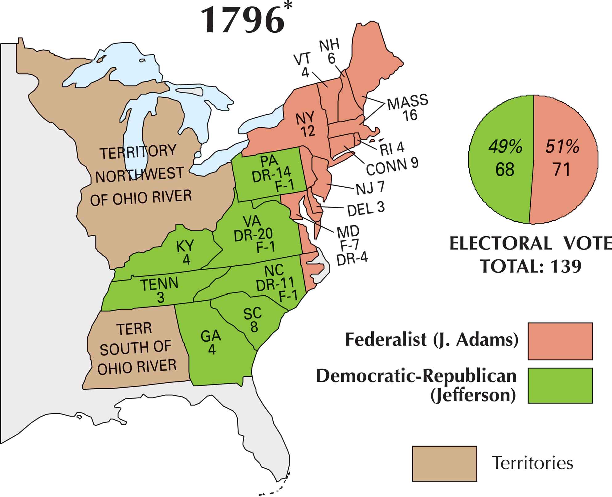
By 1796, the U.S. finally had a real political showdown. George Washington stepped aside, and two organized parties went head-to-head for the first time. While the Federalists backed John Adams, the Democratic-Republicans rallied behind Thomas Jefferson. This map marks the country’s first truly competitive presidential race with Adams winning by a narrow margin
Map Information
US Election Maps
Click on a map below to check out the US election map and results.


On the Map
Here are the states and their electoral votes, categorized by how they were split between the Federalists (J. Adams) and the Democratic-Republicans (Jefferson)
States and Electoral Votes
|
State |
Total Votes |
Federalist (Adams) |
Democratic-Republican (Jefferson) |
|
Virginia |
21 |
1 |
20 |
|
Massachusetts |
16 |
16 |
0 |
|
Pennsylvania |
15 |
1 |
14 |
|
New York |
12 |
12 |
0 |
|
North Carolina |
12 |
1 |
11 |
|
Maryland |
11 |
7 |
4 |
|
Connecticut |
9 |
9 |
0 |
|
South Carolina |
8 |
0 |
8 |
|
New Jersey |
7 |
7 |
0 |
|
New Hampshire |
6 |
6 |
0 |
|
Georgia |
4 |
0 |
4 |
|
Kentucky |
4 |
0 |
4 |
|
Rhode Island |
4 |
4 |
0 |
|
Vermont |
4 |
4 |
0 |
|
Delaware |
3 |
3 |
0 |
|
Tennessee |
3 |
0 |
3 |
Election Highlights
- Total Electoral Votes: 139
- The Winner: John Adams (Federalist) with 71 votes (51%).
- New Entry: Tennessee appears on the map for the first time with 3 electoral votes.
- Split Delegations: Unlike the previous unanimous elections, several states (VA, PA, NC, and MD) split their electoral votes between the two parties.