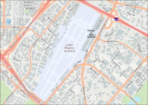
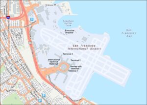
Oakland Airport Map

Spot what’s where at Oakland Airport with terminals, surrounding roads, and the shoreline edge. Our map of Oakland shows a straightforward layout, including the San Francisco Bay.
Map Information
On the Map
Interstates/Highways: I-880, State Rte 61 Major Roads: Hegenberger Rd, Doolittle Dr, 98th Ave, Ron Cowan Pkwy, Harbor Bay Pkwy, Mecartney Rd, Maitland Dr, Island Dr, Earhart Rd, Airport Dr, Air Cargo Rd, John Glen Dr, Neil Armstrong Way, Edes Ave, Empire Rd, Neptune Dr, Williams St, Aurora Dr, Catalina Ave, N Loop Rd Water Bodies: San Francisco Bay Other Landmarks: Terminal 1Tourist Maps in California
Discover all the prime locations with our tourist maps.