US Election 1820 Map
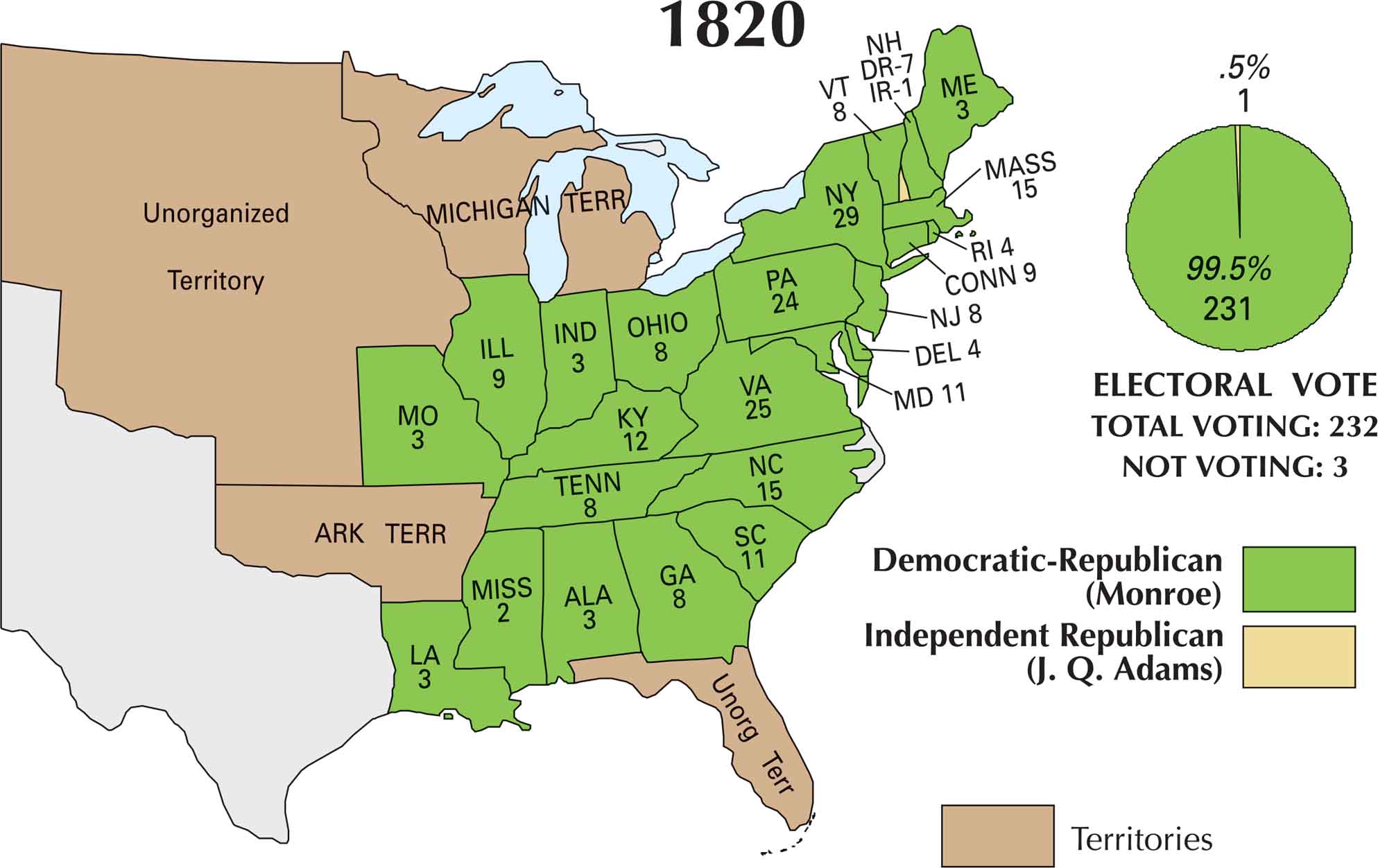
In 1820, the presidential election was more of a formality than a fight. James Monroe ran virtually unopposed, as the Federalist Party had completely fallen apart. With no serious challenger, the country gave Monroe an overwhelming win. It received every electoral vote but one. Our 1820 US election map captures that calm before the storm.
Map Information
US Election Maps
Click on a map below to check out the US election map and results.


On the Map
Here are the states and their electoral votes for James Monroe (Democratic-Republican) and John Quincy Adams (Independent Republican):
States and Electoral Votes
|
State |
Total Votes |
Monroe (DR) |
J. Q. Adams (IR) |
|
New York |
29 |
29 |
0 |
|
Virginia |
25 |
25 |
0 |
|
Pennsylvania |
24 |
24 |
0 |
|
Massachusetts |
15 |
15 |
0 |
|
North Carolina |
15 |
15 |
0 |
|
Kentucky |
12 |
12 |
0 |
|
Maryland |
11 |
11 |
0 |
|
South Carolina |
11 |
11 |
0 |
|
Connecticut |
9 |
9 |
0 |
|
Illinois |
9 |
9 |
0 |
|
New Jersey |
8 |
8 |
0 |
|
Vermont |
8 |
8 |
0 |
|
Georgia |
8 |
8 |
0 |
|
Tennessee |
8 |
8 |
0 |
|
Ohio |
8 |
8 |
0 |
|
New Hampshire |
8 |
7 |
1 |
|
Delaware |
4 |
4 |
0 |
|
Rhode Island |
4 |
4 |
0 |
|
Maine |
3 |
3 |
0 |
|
Missouri |
3 |
3 |
0 |
|
Alabama |
3 |
3 |
0 |
|
Indiana |
3 |
3 |
0 |
|
Louisiana |
3 |
3 |
0 |
|
Mississippi |
2 |
2 |
0 |
Election Summary
- Total Voting: 232
- The Winner: James Monroe (99.5%) with 231 votes.
- The “Faithless” Vote: New Hampshire cast one vote for John Quincy Adams, preventing a second unanimous election in U.S. history.
- New States: Several new states participated for the first time: Maine (ME), Missouri (MO), Alabama (ALA), Illinois (ILL), and Mississippi (MISS).
- Territorial Changes: The map now shows a massive Unorganized Territory, Michigan Terr, Ark Terr (Arkansas), and Unorg Terr in Florida.