Home » State Maps » Map of Tennessee

Map of Tennessee

Tennessee Map

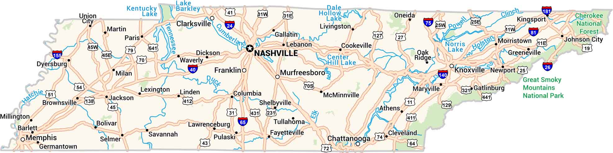
Tennessee stretches from the Mississippi River to the peaks of the Smokies. Our road map highlights its highways, lakes, rivers, parks and forests. It’s a state known for its music and movement, from blues country to the bright lights of Nashville.

Map Information

  • State of Tennessee
  • Road Map of Tennessee
  • Free for personal and commercial purpose. Attribution is required. How to attribute?

On the Map

Tennessee Location Map
State Capital: Nashville Major Cities: Chattanooga, Clarksville, Franklin, Knoxville, Memphis, Murfreesboro Cities and Towns: Athens, Barlett, Bolivar, Brownsville, Cleveland, Columbia, Cookeville, Dickson, Dyersburg, Fayetteville, Gallatin, Gatlinburg, Germantown, Greeneville, Jackson, Johnson City, Kingsport, Lawrenceburg, Lebanon, Lexington, Linden, Livingston, Martin, Maryville, McMinnville, Milan, Millington, Morristown, Newport, Oak Ridge, Oneida, Paris, Pulaski, Savannah, Selmer, Shelbyville, Tullahoma, Union City, Waverly Interstate Highways: I-24, I-26, I-40, I-64, I-65, I-75, I-81, I-140, I-155, I-181 US Routes: US-11, US-19, US-25, US-27, US-31, US-41, US-43, US-45, US-51, US-54, US-64, US-70, US-70S, US-72, US-74, US-79, US-127, US-129, US-138, US-231, US-321, US-411, US-412, US-431, US-441, US-641 Lakes and Reservoirs: Center Hill Lake, Dale Hollow Lake, Kentucky Lake, Lake Barkley, Norris Lake Rivers and Streams: Clinch River, Cumberland River, Duck River, Elk River, Hatchie River, Holston River, Powell River, Tennessee River National Parks and Forests: Cherokee National Forest, Great Smoky Mountains National Park

City Maps of Tennessee

Explore our Tennessee map collection

References

  1. Government Website of Tennessee
  2. Tennessee in Google Maps

Leave a Reply

Your email address will not be published. Required fields are marked *