South Carolina Counties and Cities Map
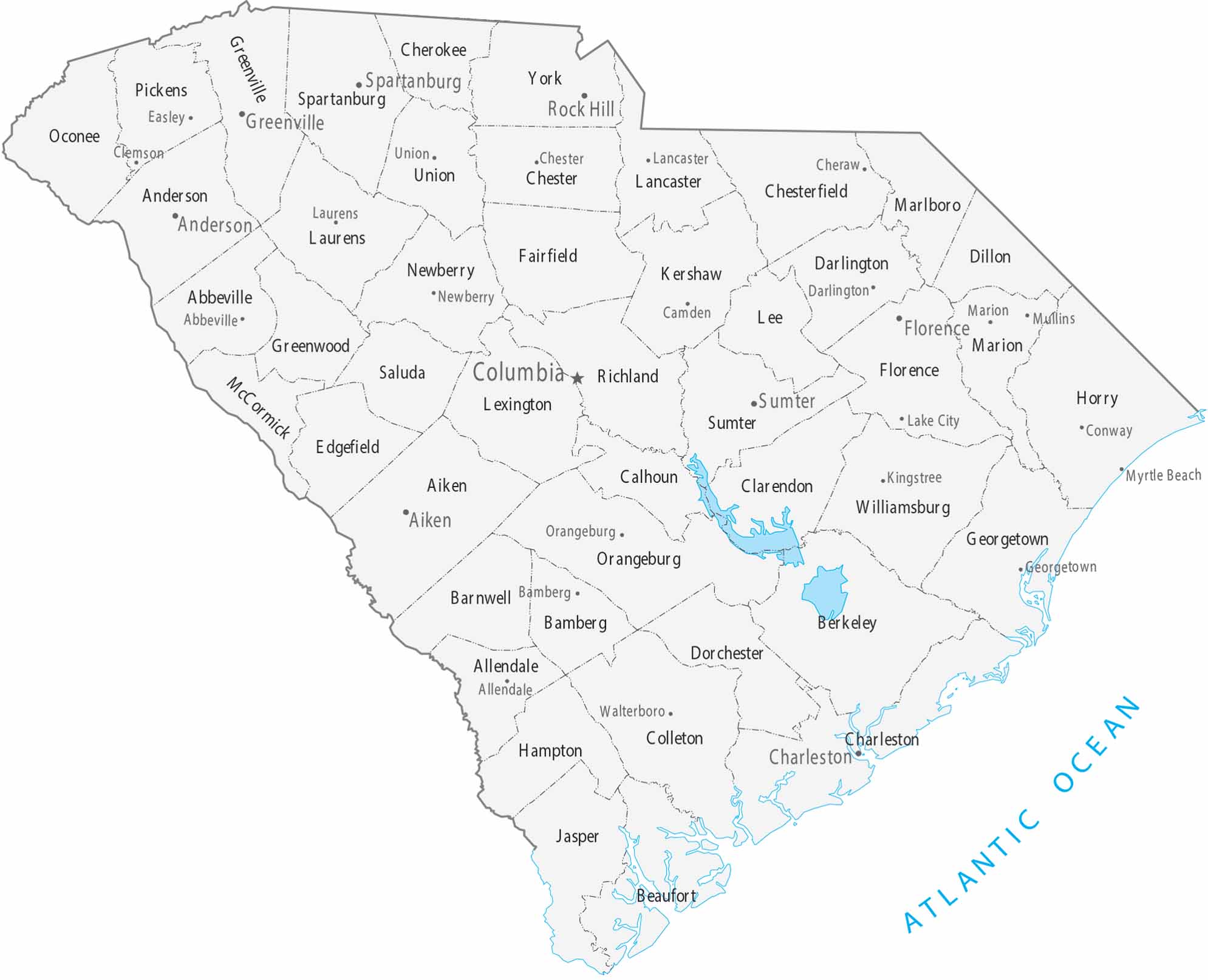
Organized into 46 counties, our map of South Carolina shows its major cities and populated areas. Columbia is the central capital with most cities in the Midlands and along the coast. Counties vary in shape across regions on our map.
Map Information
On the Map
|
Name |
Population 2024 |
Total Area (sq mi) |
FIPS Code |
|
Abbeville County |
24,607 |
512 |
45-001 |
|
Aiken County |
179,245 |
1,080.10 |
45-003 |
|
Allendale County |
7,551 |
412.4 |
45-005 |
|
Anderson County |
217,183 |
755.7 |
45-007 |
|
Bamberg County |
12,870 |
395.6 |
45-009 |
|
Barnwell County |
20,495 |
557.3 |
45-011 |
|
Beaufort County |
201,775 |
923.5 |
45-013 |
|
Berkeley County |
264,276 |
1,233.90 |
45-015 |
|
Calhoun County |
14,249 |
392.5 |
45-017 |
|
Charleston County |
431,001 |
1,358.00 |
45-019 |
|
Cherokee County |
57,770 |
397.9 |
45-021 |
|
Chester County |
32,323 |
586.2 |
45-023 |
|
Chesterfield County |
44,488 |
805.6 |
45-025 |
|
Clarendon County |
31,030 |
695.7 |
45-027 |
|
Colleton County |
39,259 |
1,133.30 |
45-029 |
|
Darlington County |
62,425 |
566.3 |
45-031 |
|
Dillon County |
27,577 |
406.8 |
45-033 |
|
Dorchester County |
174,663 |
571.2 |
45-035 |
|
Edgefield County |
29,455 |
507.1 |
45-037 |
|
Fairfield County |
20,369 |
709.9 |
45-039 |
|
Florence County |
138,049 |
804.3 |
45-041 |
|
Georgetown County |
66,035 |
1,035.20 |
45-043 |
|
Greenville County |
570,745 |
794.8 |
45-045 |
|
Greenwood County |
70,041 |
462.9 |
45-047 |
|
Hampton County |
18,172 |
562.7 |
45-049 |
|
Horry County |
413,391 |
1,254.40 |
45-051 |
|
Jasper County |
35,618 |
701.6 |
45-053 |
|
Kershaw County |
71,698 |
740.3 |
45-055 |
|
Lancaster County |
111,652 |
555 |
45-057 |
|
Laurens County |
70,545 |
723.8 |
45-059 |
|
Lee County |
15,958 |
411.2 |
45-061 |
|
Lexington County |
313,774 |
757.6 |
45-063 |
|
McCormick County |
9,983 |
393.9 |
45-065 |
|
Marion County |
28,368 |
494.2 |
45-067 |
|
Marlboro County |
25,498 |
485.5 |
45-069 |
|
Newberry County |
39,203 |
647.3 |
45-071 |
|
Oconee County |
82,475 |
673.6 |
45-073 |
|
Orangeburg County |
83,129 |
1,127.90 |
45-075 |
|
Pickens County |
138,207 |
512.6 |
45-077 |
|
Richland County |
430,651 |
771.9 |
45-079 |
|
Saluda County |
19,452 |
461.9 |
45-081 |
|
Spartanburg County |
369,256 |
819 |
45-083 |
|
Sumter County |
104,776 |
682.1 |
45-085 |
|
Union County |
26,678 |
516 |
45-087 |
|
Williamsburg County |
29,865 |
937 |
45-089 |
|
York County |
303,001 |
695.8 |
45-091 |
Counties and Cities Maps
Select any state map below to view its counties and cities map.


South Carolina State Maps
Explore maps across the Palmetto State.


