Nebraska National Parks and Forests Map
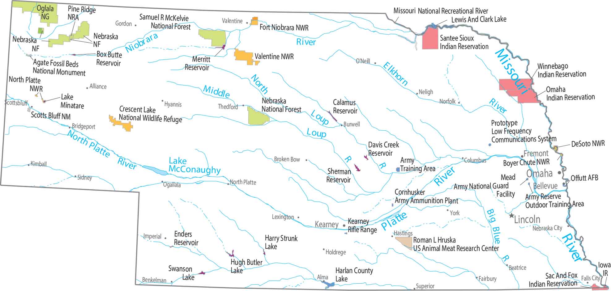
Protected land is sparse and easy to overlook at first glance. Our map shows small national forest blocks in the northwest. But most of Nebraska remains open and working land.
Map Information
On the Map
Parks, Forests and Federal Lands
National Forests: Nebraska NF, Samuel R McKelvie NF National Wildlife Refuges (NWR): Boyer Chute NWR, Crescent Lake NWR, DeSoto NWR, Fort Niobrara NWR, North Platte NWR, Valentine NWR National Recreational Areas: Missouri National Recreational River, Pine Ridge NRA Other Federal Lands: Agate Fossil Beds National Monument, Oglala National Grassland, Scotts Bluff NM Research Facilities: Roman L Hruska US Animal Meat Research Center Indian Reserves (IR): Iowa IR, Omaha IR, Sac And Fox IR, Santee Sioux IR, Winnebago IR Army, Naval and Military: Army Reserve Outdoor Training Area, Cornhusker Army Ammunition Plant, Facility Offutt AFB, Kearney Rifle Range, Mead Army National Guard, Prototype Low Frequency Communications SystemLand Information
State Capital: Lincoln Major Cities: Bellevue, Grand Island, Omaha Cities and Towns: Alliance, Alma, Beatrice, Blair, Bridgeport, Broken Bow, Burwell, Columbus, Dunning, Fairbury, Falls City, Fremont, Gordon, Harington, Hastings, Holdrege, Hyannis, Imperial, Kearney, Kimball, Lexington, Neligh, Norfolk, North Platte, O’Neill, Scottsbluff, Sidney, Superior, Thedford, Valentine, York Lakes and Reservoirs: Box Butte Reservoir, Calamus Reservoir, Davis Creek Reservoir, Enders Reservoir, Harlan County Lake, Harry Strunk Lake, Hugh Butler Lake, Lake Minatare, Lewis And Clark Lake, McConaughy Lake, Merritt Reservoir, Platte Lake, Sherman Reservoir, Swanson Lake Rivers and Streams: Big Blue River, Elkhorn River, Missouri River, Niobrara River, North Platte RiverNebraska State Maps
Examine maps showing prairies and cities in Nebraska.