Arizona National Parks and Forests Map
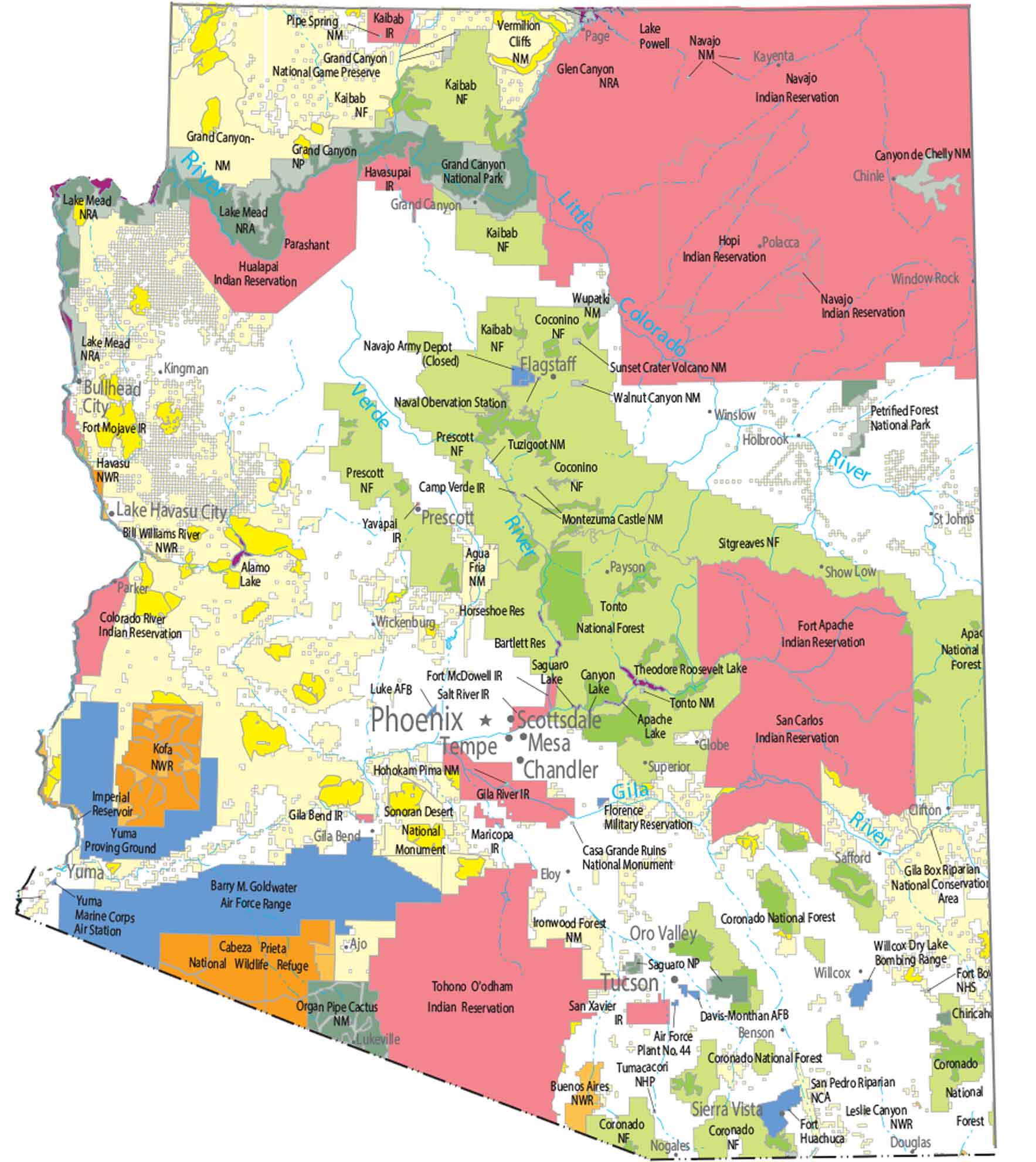
Our national parks and forests map of Arizona shows the Grand Canyon in the northern part of the state. Higher elevations hold most of Arizona’s forests and parks. On the other hand, lower elevations show far less protected land.
Map Information
On the Map
Parks, Forests and Federal Lands
National Parks (NP): Grand Canyon NP, Petrified Forest NP, Saguaro NP National Forests (NF): Coronado NF, Tonto NF, Sitgreaves NF, Apache NF, Prescott NF, Kaibab NF, Coconino NF National Monuments (NM): Coronado NM, Casa Grande Ruins NM, Ironwood Forest NM, Navajo NM, Canyon de Chelly NM, Tuzigoot NM, Montezuma Castle NM, Agua Fria NM, Hohokam Pima NM, Sonoran Desert NM, Organ Pipe Cactus NM, Tonto NM, Vermilion Cliffs NM, Wupatki NM, Sunset Crater Volcano NM, Walnut Canyon NM, Pipe Spring NM, Grand Canyon-Parashant NM, Chiricahua NM National Wildlife Refuges (NWR): Buenos Aires NWR, Leslie Canyon NWR, San Bernardino NWR, Kofa NWR, Cibola NWR, Imperial NWR, Cabeza Prieta NWR, Havasu NWR, Bill Williams River NWR National Historic Parks and Sites: Tumacacori NHP, Fort Bowie National Historic Site, Grand Canyon National Game Preserve National Recreational Areas (NRA): Lake Mead NRA, Glen Canyon NRA National Conservation Areas (NCA): Gila Box Riparian NCA, San Pedro Riparian NCALand Information
State Capital: Phoenix Major Rivers: Colorado River, Verde River Lakes and Reservoirs: Theodore Roosevelt Lake, Apache Lake, Canyon Lake, Saguaro Lake, Horseshoe Reservoir, Bartlett Reservoir, Lake Powell, Imperial Reservoir, Lake Mead, Lake Mohave, Alamo Lake Indian Reserves: San Xavier IR, San Carlos IR, Tohono O’odham IR, Salt River IR, Gila River IR, Maricopa IR, Navajo IR, Hopi IR, Fort Apache IR, Camp Verde IR, Yavapai IR, Gila Bend IR, Fort McDowell IR, Havasupai IR, Hualapai IR, Cocopah IR, Kaibab IR, Fort Mojave IR, Colorado River IR Army, Naval and Military: Air Force Plant No. 44, Davis-Monthan AFB, Willcox Dry Lake Bombing Range, Fort Huachuca, Florence Military Reservation, Naval Observation Station, Navajo Army Depot (Closed), Yuma Proving Ground, Yuma Marine Corps Air Station, Barry M. Goldwater Air Force Range, Luke Air Force BaseArizona State Maps
Check out our Arizona state maps we’ve put together


