Pennsylvania Counties and Cities Map
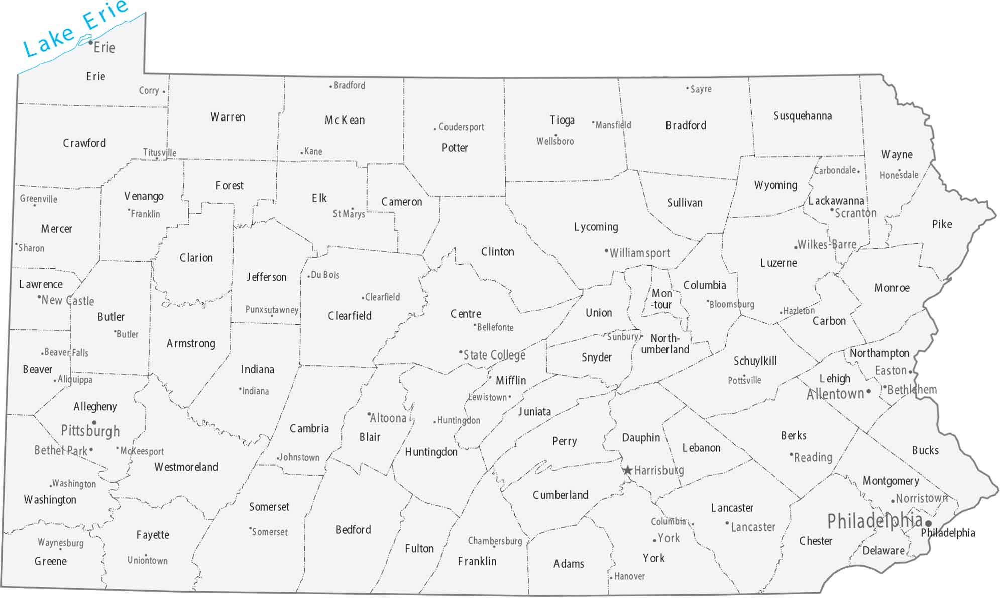
The 67 counties on our map of Pennsylvania are defined by the Appalachian Mountains. Harrisburg acts as the capital, positioned between Philadelphia and Pittsburgh.
Map Information
On the Map
|
Name |
Population 2024 |
Total Area (sq mi) |
FIPS Code |
|
Adams County |
107,914 |
521.7 |
42-001 |
|
Allegheny County |
1,231,814 |
744.5 |
42-003 |
|
Armstrong County |
63,679 |
663.8 |
42-005 |
|
Beaver County |
165,540 |
444 |
42-007 |
|
Bedford County |
47,643 |
1,016.90 |
42-009 |
|
Berks County |
439,117 |
865.7 |
42-011 |
|
Blair County |
120,269 |
527.1 |
42-013 |
|
Bradford County |
59,699 |
1,161.00 |
42-015 |
|
Bucks County |
650,131 |
621.9 |
42-017 |
|
Butler County |
199,341 |
794.7 |
42-019 |
|
Cambria County |
130,108 |
693.6 |
42-021 |
|
Cameron County |
4,348 |
398.4 |
42-023 |
|
Carbon County |
65,743 |
387.4 |
42-025 |
|
Centre County |
159,805 |
1,113.00 |
42-027 |
|
Chester County |
560,745 |
759.2 |
42-029 |
|
Clarion County |
36,855 |
609.8 |
42-031 |
|
Clearfield County |
78,132 |
1,153.90 |
42-033 |
|
Clinton County |
37,865 |
896.9 |
42-035 |
|
Columbia County |
66,012 |
490.2 |
42-037 |
|
Crawford County |
82,089 |
1,037.50 |
42-039 |
|
Cumberland County |
275,516 |
550.3 |
42-041 |
|
Dauphin County |
293,029 |
558.2 |
42-043 |
|
Delaware County |
584,882 |
190.6 |
42-045 |
|
Elk County |
30,124 |
832.3 |
42-047 |
|
Erie County |
267,750 |
1,558.20 |
42-049 |
|
Fayette County |
123,941 |
798.3 |
42-051 |
|
Forest County |
6,601 |
430.5 |
42-053 |
|
Franklin County |
159,285 |
772.8 |
42-055 |
|
Fulton County |
14,452 |
438.1 |
42-057 |
|
Greene County |
33,960 |
578 |
42-059 |
|
Huntingdon County |
43,359 |
889.3 |
42-061 |
|
Indiana County |
82,953 |
834.3 |
42-063 |
|
Jefferson County |
43,367 |
656.8 |
42-065 |
|
Juniata County |
23,395 |
393.5 |
42-067 |
|
Lackawanna County |
216,859 |
464.9 |
42-069 |
|
Lancaster County |
563,293 |
983.8 |
42-071 |
|
Lawrence County |
84,233 |
362.7 |
42-073 |
|
Lebanon County |
145,319 |
362.5 |
42-075 |
|
Lehigh County |
385,655 |
348.2 |
42-077 |
|
Luzerne County |
331,379 |
906.3 |
42-079 |
|
Lycoming County |
113,236 |
1,243.80 |
42-081 |
|
McKean County |
39,478 |
984.2 |
42-083 |
|
Mercer County |
108,140 |
682.6 |
42-085 |
|
Mifflin County |
45,935 |
414.7 |
42-087 |
|
Monroe County |
166,523 |
617.1 |
42-089 |
|
Montgomery County |
879,190 |
487.2 |
42-091 |
|
Montour County |
18,115 |
132.3 |
42-093 |
|
Northampton County |
322,989 |
377.1 |
42-095 |
|
Northumberland County |
90,027 |
477.5 |
42-097 |
|
Perry County |
46,816 |
555.5 |
42-099 |
|
Philadelphia County |
1,573,916 |
142.7 |
42-101 |
|
Pike County |
62,376 |
566.8 |
42-103 |
|
Potter County |
15,993 |
1,081.50 |
42-105 |
|
Schuylkill County |
144,523 |
782.8 |
42-107 |
|
Snyder County |
39,627 |
331.5 |
42-109 |
|
Somerset County |
72,134 |
1,080.90 |
42-111 |
|
Sullivan County |
5,927 |
452.5 |
42-113 |
|
Susquehanna County |
38,100 |
832.1 |
42-115 |
|
Tioga County |
40,698 |
1,137.00 |
42-117 |
|
Union County |
42,159 |
317.7 |
42-119 |
|
Venango County |
49,476 |
682.8 |
42-121 |
|
Warren County |
37,373 |
898.6 |
42-123 |
|
Washington County |
210,434 |
860.9 |
42-125 |
|
Wayne County |
51,419 |
750.6 |
42-127 |
|
Westmoreland County |
350,935 |
1,036.10 |
42-129 |
|
Wyoming County |
25,771 |
405 |
42-131 |
|
York County |
471,240 |
910.7 |
42-133 |
Counties and Cities Maps
Select any state map below to view its counties and cities map.


Pennsylvania State Maps
Browse maps throughout the Keystone State.


