Mississippi National Parks and Forests Map
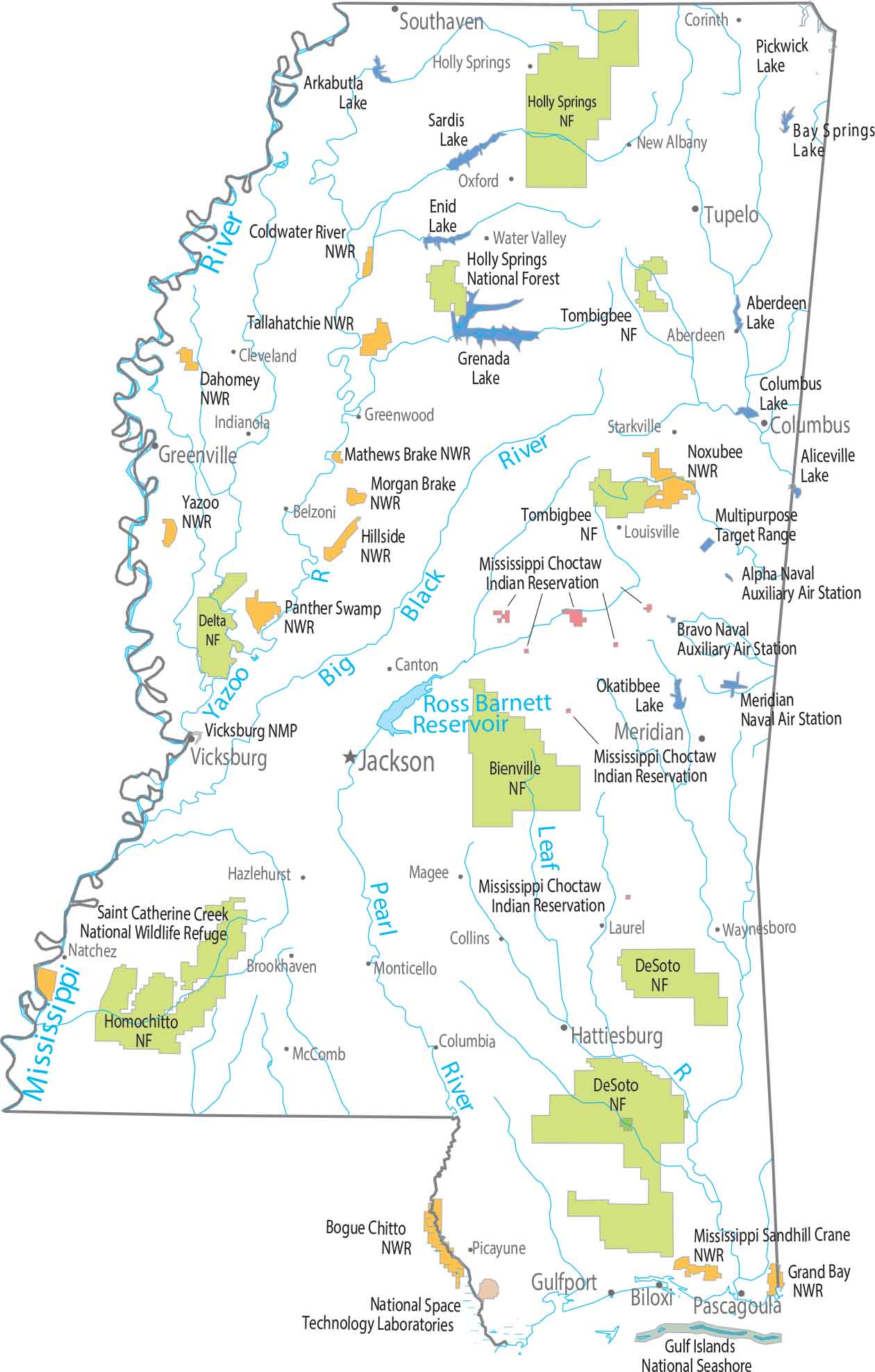
Our map shows forest land laid out as small, broken pieces in the state of Mississippi. Delta National Forest sits in the flat northwest, while Bienville, Homochitto, Tombigbee, and Holly Springs National Forests are situated across the state. No major national park anchors the state.
Map Information
On the Map
Parks, Forests and Federal Lands
National Forests (NF): Bienville NF, Delta NF, DeSoto NF, Holly Springs NF, Homochitto NF, Tombigbeen NF National Wildlife Refuges (NWR): Bogue Chitto NWR, Coldwater River NWR, Dahomey NWR, Grand Bay NWR, Hillside NWR, Mathews Brake NWR, Mississippi Sandhill Crane NWR, Morgan Brake NWR, Noxubee NWR, Panther Swamp NWR, Saint Catherine Creek NWR, Tallahatchie NWR, Yazoo NWR Federal Lands: Gulf Islands National Seashore, National Space Technology Laboratories, Vicksburg NMP Indian Reserves: Mississippi Choctaw Indian Reservation Army, Naval and Military: Alpha Naval Auxiliary Air Station, Bravo Naval Auxiliary Air Station, Meridian Naval Air Station, Multipurpose Target RangeLand Information
State Capital: Jackson Major Cities: Gulfport, Hattiesburg Cities and Towns: Aberdeen, Biloxi, Brookhaven, Canton, Cleveland, Collins, Columbia, Columbus, Corinth, Greenville, Greenwood, Hazlehurst, Holly Springs, Indianola, Laurel, Louisville, Magee, McComb, Meridian, Monticello, Natchez, New Albany, Oxford, Pascagoula, Picayune, Southaven, Starkville, Tupelo, Vicksburg, Water Valley, Waynesboro Lakes and Reservoirs: Ross Barnett Reservoir Rivers and Streams: Big Black River, Leaf River, Mississippi River, Pearl River, Yazoo RiverMississippi State Maps
Explore maps of Mississippi’s towns, rivers, and roads.


