US Election 1848 Map
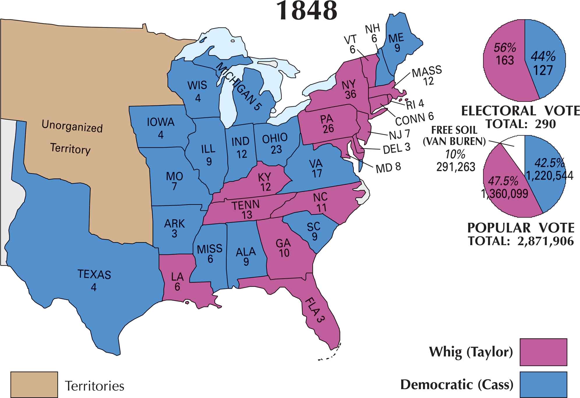
This map of the US 1848 election shows a country divided. Zachary Taylor’s Whig support spreads across the South and much of the West. Lewis Cass’s Democratic strength is mostly in the Northeast and parts of the Midwest. But Taylor’s popularity as a military hero helped him win key states.
Map Information
US Election Maps
Click on a map below to check out the US election map and results.

On the Map
Based on our 1848 Presidential Election map, the electoral votes were divided between Zachary Taylor (Whig) and Lewis Cass (Democrat).
States and Electoral Votes
|
State |
Total Votes |
Taylor (Whig) |
Cass (D) |
|
New York |
36 |
36 |
0 |
|
Pennsylvania |
26 |
26 |
0 |
|
Ohio |
23 |
0 |
23 |
|
Virginia |
17 |
0 |
17 |
|
Massachusetts |
12 |
12 |
0 |
|
Indiana |
12 |
0 |
12 |
|
Kentucky |
12 |
12 |
0 |
|
Tennessee |
13 |
13 |
0 |
|
North Carolina |
11 |
11 |
0 |
|
Georgia |
10 |
10 |
0 |
|
Maryland |
8 |
8 |
0 |
|
South Carolina |
9 |
0 |
9 |
|
Maine |
9 |
0 |
9 |
|
Alabama |
9 |
0 |
9 |
|
Illinois |
9 |
0 |
9 |
|
Missouri |
7 |
0 |
7 |
|
New Jersey |
7 |
7 |
0 |
|
Connecticut |
6 |
6 |
0 |
|
New Hampshire |
6 |
0 |
6 |
|
Vermont |
6 |
6 |
0 |
|
Louisiana |
6 |
6 |
0 |
|
Mississippi |
6 |
0 |
6 |
|
Michigan |
5 |
0 |
5 |
|
Rhode Island |
4 |
4 |
0 |
|
Iowa |
4 |
0 |
4 |
|
Wisconsin |
4 |
0 |
4 |
|
Texas |
4 |
0 |
4 |
|
Delaware |
3 |
3 |
0 |
|
Florida |
3 |
3 |
0 |
|
Arkansas |
3 |
0 |
3 |
Election Summary
- Total Electoral Votes: 290.
- The Winner: Zachary Taylor (Whig) with 163 votes (56%).
- Popular Vote: Totaling 2,871,906, Taylor won with 47.5% (1,360,099 votes).
- New States: Texas (4), Florida (3), Iowa (4), and Wisconsin (4) participated as states for the first time.
- Third Party Impact: The Free Soil Party (Van Buren) captured 10% of the popular vote (291,263), though it earned zero electoral votes.
- Territories: The map now shows a vast Unorganized Territory in the West.