US Election 1844 Map
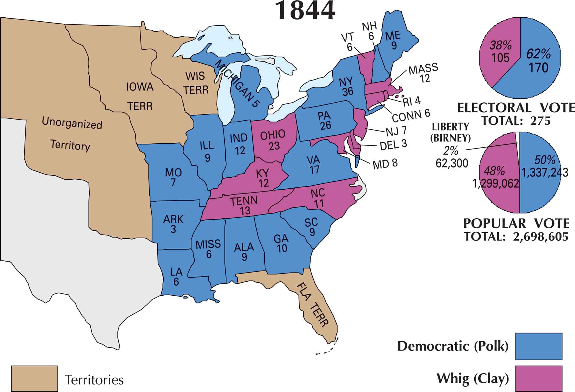
Our US election 1844 map shows how sharply divided the nation had become. James K. Polk, the Democratic candidate, carried most of the South and much of the West. Henry Clay from the Whig Party, held parts of the Northeast. The election was one of the closest in American history but Polk won the presidency.
Map Information
US Election Maps
Click on a map below to check out the US election map and results.

On the Map
Based on the 1844 Presidential Election map, the electoral votes were divided between James K. Polk (Democrat) and Henry Clay (Whig).
States and Electoral Votes
|
State |
Total Votes |
Polk (D) |
Clay (Whig) |
|
New York |
36 |
36 |
0 |
|
Pennsylvania |
26 |
26 |
0 |
|
Ohio |
23 |
0 |
23 |
|
Virginia |
17 |
17 |
0 |
|
Tennessee |
13 |
0 |
13 |
|
Massachusetts |
12 |
0 |
12 |
|
Kentucky |
12 |
0 |
12 |
|
North Carolina |
11 |
0 |
11 |
|
Georgia |
10 |
10 |
0 |
|
Maryland |
8 |
0 |
8 |
|
Maine |
9 |
9 |
0 |
|
Indiana |
12 |
12 |
0 |
|
New Jersey |
7 |
0 |
7 |
|
Connecticut |
6 |
0 |
6 |
|
New Hampshire |
6 |
6 |
0 |
|
Vermont |
6 |
0 |
6 |
|
Alabama |
9 |
9 |
0 |
|
Louisiana |
6 |
6 |
0 |
|
Illinois |
9 |
9 |
0 |
|
Rhode Island |
4 |
0 |
4 |
|
Mississippi |
6 |
6 |
0 |
|
Missouri |
7 |
7 |
0 |
|
Michigan |
5 |
5 |
0 |
|
Arkansas |
3 |
3 |
0 |
|
Delaware |
3 |
0 |
3 |
|
South Carolina |
9 |
9 |
0 |
Election Summary
- Total Electoral Votes: 275
- The Winner: James K. Polk (Democrat) with 170 votes (62%).
- Popular Vote: Polk won with 50% (1,337,243 votes).
- Close Contest: Despite the wide electoral margin, the popular vote was very tight (48% for Clay).
- Third Party: The Liberty Party (Birney) took 2% of the popular vote (62,300), which influenced the outcome in key states like New York.
- Shifting Power: Note the significant drop in electoral votes for New York (from 42 in 1840 to 36) and Pennsylvania (from 30 to 26), reflecting the results of the 1840 census reapportionment.
- Territories: The map continues to show Iowa Territory, Wisconsin Territory, Fla Terr, and the Unorganized Territory.