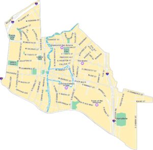
Downtown San Antonio Map

Our map of Downtown San Antonio shows the area surrounding the River Walk and Alamo Plaza. It shows streets, parks, and the river loops running through the city center.
Map Information
San Antonio Neighborhood Maps
See our neighborhood maps for a closer look of the city.
On the Map
Interstates/Highways: I-35, I-37, I-10 Major Roads: Commerce St, Market St, Houston St, Broadway, Alamo St, Santa Rosa St, Main Ave, Saint Marys St, Flores St, Soledad St, Pecan St, Travis St, Nueva St, San Pedro Ave, Navarro St, Presa St, Bonham St, Bowie St, Elm St, Hoefgen Ave Major Rivers: San Antonio River Parks: Travis Park, Milam Square, Legacy Park, Piazza Italia Park Landmarks: The Alamo, River Walk, Alamodome, Tower of the Americas, La Villita Historic Village, Hopscotch San AntonioCity Maps of Texas
Explore our map collection of Texas cities.


