Home » State Maps » Idaho National Parks and Forests Map

Idaho National Parks and Forests Map

Idaho National Parks and Forests Map

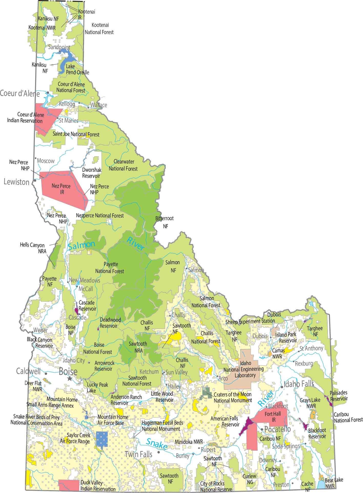
Our map shows one of the largest uninterrupted protected regions in the country. Central Idaho is almost entirely forest and wilderness. Idaho has several national forests, but they are sometimes grouped into larger administrative units.

Map Information

  • National Parks and Forests Map of Idaho
  • Original map provided by National Map. Map updated by our team.
  • Free for personal and commercial purpose. Attribution is required. How to attribute?

On the Map

Idaho Location Map

Parks and Forests

National Parks: Yellowstone National Park National Forests (NF): Bitterroot NF, Boise NF, Cache NF, Caribou NF, Challis NF, Clearwater NF, Coeur d’Alene NF, Kaniksu NF, Kootenai NF, Nezperce NF, Payette NF, Saint Joe NF, Salmon NF, Sawtooth NF, Targhee NF, Targhee NF National Wildlife Refuges (NWR): Bear Lake NWR, Camas NWR, Deer Flat NWR, Grays Lake NWR, Kootenai NWR, Minidoka NWR National Conservation Areas (NCA): Snake River Birds of Prey NCA National Recreational Areas (NRA): Hells Canyon NRA, Sawtooth NRA National Monuments (NM): Craters of the Moon NM, Hagerman Fossil Beds NM Other Landmarks: City of Rocks National Reserve, Curlew National Grassland, Dubois Sheep Experiment Station, Idaho National Engineering Laboratory, Nez Perce NHP

Land Information

State Capital: Boise Major Cities: Caldwell, Coeur d’Alene, Idaho Falls, Lewiston, Meridian, Nampa, Pocatello, Twin Falls Cities and Towns: American Falls, Arco, Blackfoot, Bonners Ferry, Burley, Cascade, Challis, Chubbuck, Downey, Dubois, Gooding, Grangeville, Hailey, Idaho City, Kellogg, Ketchum, Malad City, McCall, Montpelier, Moscow, Mountain Home, New Meadows, Orofino, Payette, Preston, Rexburg, Rupert, Salmon, Sandpoint, Shoshone, Soda Springs, St Anthony, St Maries, Sun Valley, Wallace, Weiser Lakes and Reservoirs: American Falls Reservoir, Anderson Ranch Reservoir, Arrowrock Reservoir, Black Canyon Reservoir, Blackfoot Reservoir, Cascade Reservoir, Deadwood Reservoir, Dworshak Reservoir, Island Park Reservoir, Lake Pend Oreille, Little Wood Reservoir, Lucky Peak Lake, Palisades Reservoir Rivers and Streams: Salmon River, Snake River Indian Reserves (IR): Coeur d’Alene IR, Duck Valley IR, Fort Hall IR, Kootenai IR, Nez Perce IR Army, Naval and Military: Saylor Creek Air Force Range, Mountain Home Small Arms Range Annex, Mountain Home Air Force Base

References

  1. National Park Service NPS Web Maps
  2. USDA Forest Service Digital Maps

Leave a Reply

Your email address will not be published. Required fields are marked *