Huntsville Botanical Garden Map

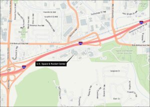
Get oriented with our map showing Huntsville Botanical Garden with park pathways and trails. It’s located off I-565 and Bob Wallace Ave. Although Huntsville is known for its space industry, it also has a nice botanical garden close by.
Map Information
On the Map
Interstates/Highways: I-565 Major Roads: Bob Wallace Ave, Drake Ave, Patton Rd, Acklen Dr, Ashland Dr, Bayless Dr, Belvoir Dr, Buffington Rd, Cerro Vista Dr, Coffee Dr, Crestwood Dr, Dyer Cir, Fairacres Rd, Gesman Pl, Goss Rd, Hawthorne Ave, Hillsboro Rd, Hughes Dr, Morgan St, McVay St Rivers and Creeks: McDonald Creek, Sherwood Creek Parks/Landmarks: Metro Kiwanis Sportsplex, Space and Rocket Center Grounds, Youth CenterTourist Maps in Alabama
Discover all the prime locations with our tourist maps.