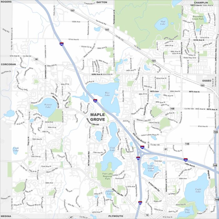
Map of Maple Grove, Minnesota
See Maple Grove on our road map. Lakes and parks break up its suburban grid. Highways connect it quickly into the Twin Cities. Map Information
Our map of Maple Valley shows its highways winding through. The Cedar River and nearby lakes play a big role here.
Explore Maplewood with our map. Highways form key routes around its neighborhoods, lakes and green spaces.
Marana stretches across the desert northwest of Tucson. Our map shows its highways, rail line, and scattered neighborhoods.
Our map of Marathon shows its location along the Florida Keys and US-1. Bridges connect its islands across turquoise waters.
Our map of Marco Island shows its grid of canals and waterfront streets. The Gulf Coast borders the city to the west.
Explore our map of Margate in Broward County, Florida. Highways cut across neighborhoods, with canals and lakes scattered throughout.
Maricopa sits in the Sonoran Desert south of Phoenix. Our map outlines its planned neighborhoods, highways, and open desert land.
See Marietta on our road map. Interstate 75 runs beside the city, linking it with downtown. The Chattahoochee River flows to the east.
Our map of Marina shows its streets set against the Pacific coastline. The city borders Monterey Bay and Fort Ord Dunes.
Check out Marion on our map. It’s situated northeast of Cedar Rapids. Highways cut across neighborhoods and parks within the city.
Marion lies north of Columbus in central Ohio. Our map highlights its highway connections, rail lines, and downtown area.
Discover Marlborough, Massachusetts with our road map. Interstate 495 crosses the city with lakes set along its edges.
Our map of Marquette shows its shoreline on Lake Superior. The city’s streets rise into hills behind the waterfront.
Marshall lies in northeast Texas near the Louisiana border. Our map shows its highways meeting around the downtown grid.