Home » State Maps » Kentucky Physical Map

Kentucky Physical Map

Kentucky Physical Map

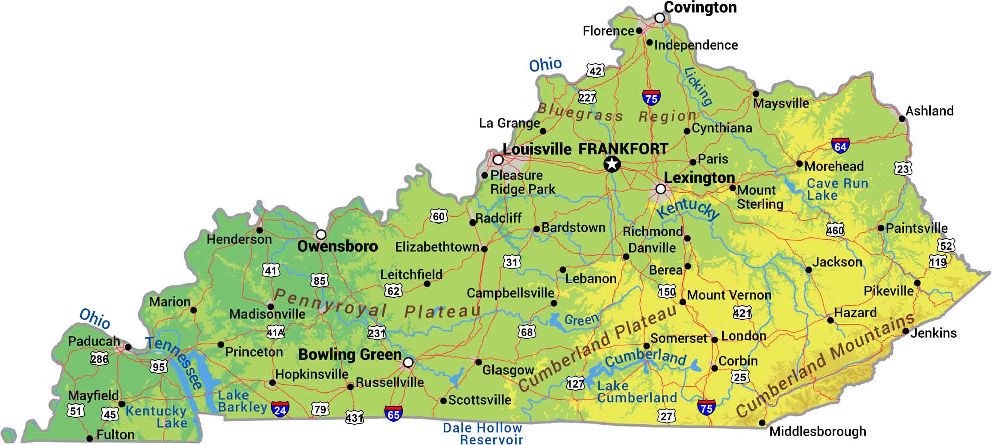
It’s about contrast here in Kentucky. Eastern Kentucky brings the Cumberland Mountains, while western Kentucky flattens into river lowlands. The Bluegrass region in the center rolls with gentle hills. Our physical map of Kentucky shows how this state transitions from mountain hollows to farmland as you move across it.

Map Information

  • State of Kentucky
  • Physical Map of Kentucky
  • Free for personal and commercial purpose. Attribution is required. How to attribute?

On the Map

Kentucky Location Map
Physical Features: Bluegrass Region, Pennyroyal Plateau, Cumberland Plateau, Cumberland Mountains State Capital: Frankfort Major Cities: Lexington, Louisville Cities and Towns: Ashland, Bardstown, Berea, Bowling Green, Campbellsville, Corbin, Covington, Cynthiana, Danville, Elizabethtown, Florence, Fulton, Glasgow, Harlan, Hazard, Henderson, Hopkinsville, Independence, Jackson, Jenkins, La Grange, Lebanon, Leitchfield, London, Madisonville, Marion, Maysville, Middlesborough, Morehead, Mount Sterling, Mount Vernon, Owensboro, Paducah, Paris, Pikeville, Pleasure Ridge Park, Princeton, Radcliff, Richmond, Russellville, Scottsville, Somerset Interstate Highways: I-24, I-64, I-65, I-71, I-75, I-265 US Routes: US-23, US-25, US-27, US-31, US-41, US-41A, US-42, US-45, US-51, US-52, US-60, US-62, US-68, US-79, US-119, US-127, US-150, US-231, US-421, US-431, US-460 Lakes and Reservoirs: Cave Run Lake, Dale Hollow Reservoir, Kentucky Lake, Lake Barkley, Lake Cumberland Rivers and Streams: Cumberland River, Green River, Kentucky River, Licking River, Ohio River, Tennessee River

References

  1. Shuttle Radar Topography Mission Elevation
  2. National Map TopoBuilder Application

Leave a Reply

Your email address will not be published. Required fields are marked *