Idaho County Map
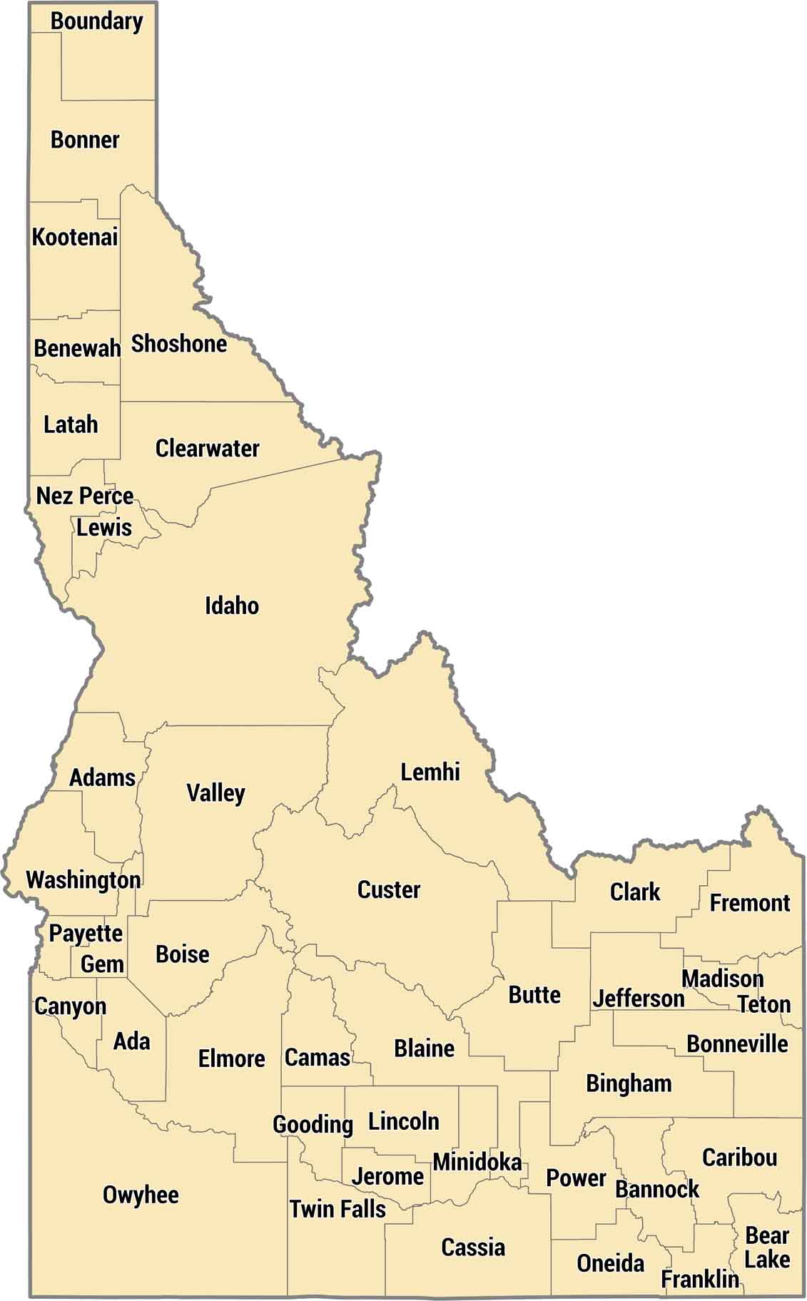
Idaho has 44 counties spread across mountains, plains, and canyons. Western counties tend to follow the Snake River. In the central mountainous areas, the lines often run along the crests of mountain ranges. The southern counties are along I-84 and hold most of the population in cities like Boise and Twin Falls.
Map Information
On the Map
Our table below provides you with population, area, and FIPS code for each county.
|
Name |
Population 2024 |
Total Area (sq mi) |
FIPS Code |
|
Ada County |
535,799 |
1,060.60 |
16-001 |
|
Adams County |
4,998 |
1,369.50 |
16-003 |
|
Bannock County |
91,010 |
1,148.00 |
16-005 |
|
Bear Lake County |
6,779 |
1,049.60 |
16-007 |
|
Benewah County |
10,529 |
784.2 |
16-009 |
|
Bingham County |
50,889 |
2,120.20 |
16-011 |
|
Blaine County |
25,261 |
2,655.00 |
16-013 |
|
Boise County |
8,581 |
1,906.90 |
16-015 |
|
Bonner County |
53,955 |
1,918.10 |
16-017 |
|
Bonneville County |
133,644 |
1,900.30 |
16-019 |
|
Boundary County |
14,040 |
1,278.00 |
16-021 |
|
Butte County |
2,735 |
2,238.50 |
16-023 |
|
Camas County |
1,247 |
1,078.70 |
16-025 |
|
Canyon County |
266,892 |
603.7 |
16-027 |
|
Caribou County |
7,239 |
1,798.60 |
16-029 |
|
Cassia County |
25,976 |
2,580.70 |
16-031 |
|
Clark County |
794 |
1,764.10 |
16-033 |
|
Clearwater County |
9,151 |
2,488.00 |
16-035 |
|
Custer County |
4,597 |
4,938.60 |
16-037 |
|
Elmore County |
29,729 |
3,101.40 |
16-039 |
|
Franklin County |
15,638 |
667.7 |
16-041 |
|
Fremont County |
14,399 |
1,896.20 |
16-043 |
|
Gem County |
21,857 |
564.6 |
16-045 |
|
Gooding County |
16,189 |
734.1 |
16-047 |
|
Idaho County |
17,912 |
8,503.50 |
16-049 |
|
Jefferson County |
34,854 |
1,105.70 |
16-051 |
|
Jerome County |
26,056 |
602.5 |
16-053 |
|
Kootenai County |
188,323 |
1,309.00 |
16-055 |
|
Latah County |
42,180 |
1,076.80 |
16-057 |
|
Lemhi County |
8,397 |
4,569.10 |
16-059 |
|
Lewis County |
3,728 |
479.7 |
16-061 |
|
Lincoln County |
5,556 |
1,205.80 |
16-063 |
|
Madison County |
55,549 |
473.3 |
16-065 |
|
Minidoka County |
22,691 |
762.4 |
16-067 |
|
Nez Perce County |
42,847 |
856.5 |
16-069 |
|
Oneida County |
4,976 |
1,200.50 |
16-071 |
|
Owyhee County |
12,748 |
7,696.80 |
16-073 |
|
Payette County |
27,662 |
410.3 |
16-075 |
|
Power County |
8,381 |
1,442.10 |
16-077 |
|
Shoshone County |
14,074 |
2,642.80 |
16-079 |
|
Teton County |
12,932 |
450.2 |
16-081 |
|
Twin Falls County |
96,509 |
1,928.70 |
16-083 |
|
Valley County |
12,777 |
3,733.50 |
16-085 |
|
Washington County |
11,539 |
1,473.40 |
16-087 |


State County Maps
Click on a map below to check out county maps of each state.


