US Election 2000 Map
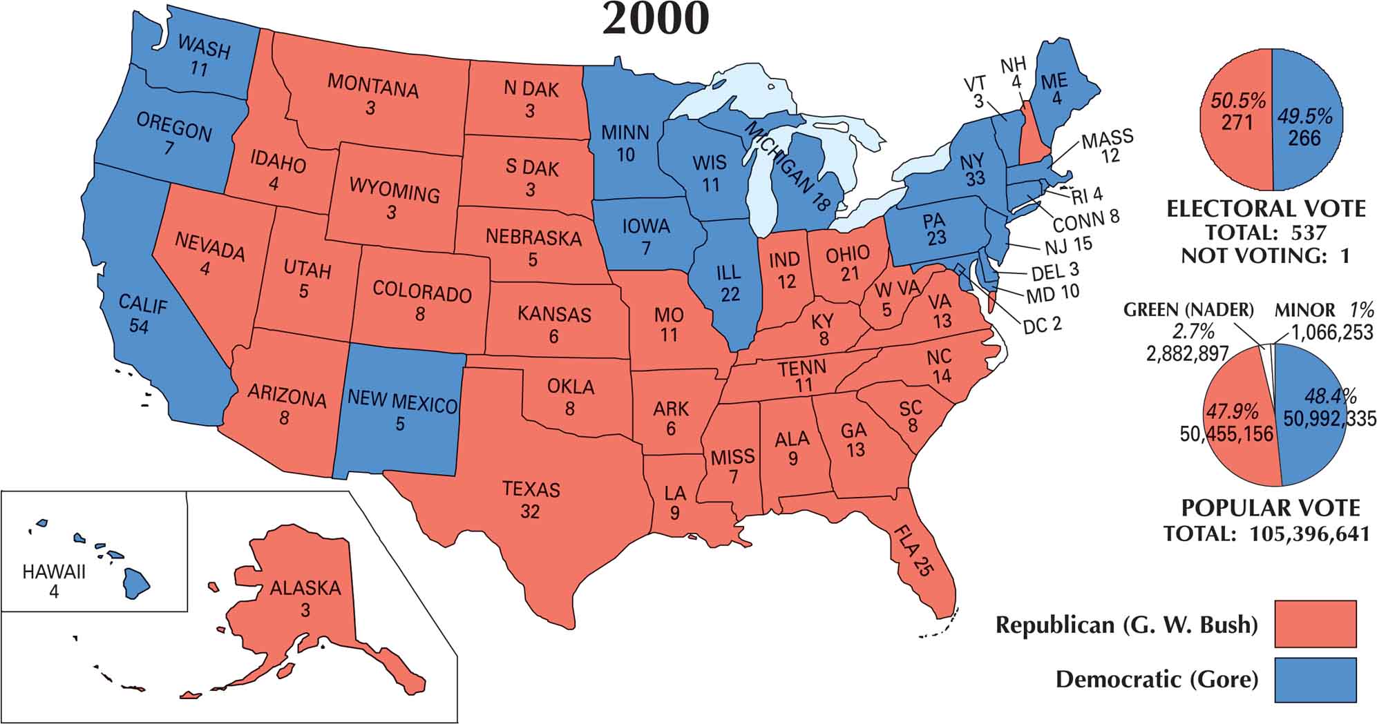
The 2000 U.S. election map is split almost perfectly in half. George W. Bush won the presidency after one of the closest and most contested races in U.S. history. Red dominates the South, Midwest, and much of the Mountain West. Blue is clustered along the coasts and Great Lakes. The narrow result came down to Florida and it was just a few hundred votes deciding an entire election.
Map Information
US Election Maps
Click on a map below to check out the US election map and results.


On the Map
The 2000 U.S. Presidential Election was one of the closest and most controversial in history. Republican George W. Bush won the presidency despite losing the popular vote to Democrat Al Gore. The last time this happened was back in 1888.
States and Electoral Votes
|
State Name |
Total Votes |
George W. Bush (R) |
Al Gore (D) |
|
California |
54 |
0 |
54 |
|
New York |
33 |
0 |
33 |
|
Texas |
32 |
32 |
0 |
|
Florida |
25 |
25 |
0 |
|
Pennsylvania |
23 |
0 |
23 |
|
Illinois |
22 |
0 |
22 |
|
Ohio |
21 |
21 |
0 |
|
Michigan |
18 |
0 |
18 |
|
New Jersey |
15 |
0 |
15 |
|
North Carolina |
14 |
14 |
0 |
|
Georgia |
13 |
13 |
0 |
|
Virginia |
13 |
13 |
0 |
|
Massachusetts |
12 |
0 |
12 |
|
Indiana |
12 |
12 |
0 |
|
Missouri |
11 |
11 |
0 |
|
Tennessee |
11 |
11 |
0 |
|
Washington |
11 |
0 |
11 |
|
Wisconsin |
11 |
0 |
11 |
|
Maryland |
10 |
0 |
10 |
|
Minnesota |
10 |
0 |
10 |
|
Alabama |
9 |
9 |
0 |
|
Louisiana |
9 |
9 |
0 |
|
Arizona |
8 |
8 |
0 |
|
Colorado |
8 |
8 |
0 |
|
Connecticut |
8 |
0 |
8 |
|
Kentucky |
8 |
8 |
0 |
|
Oklahoma |
8 |
8 |
0 |
|
South Carolina |
8 |
8 |
0 |
|
Iowa |
7 |
0 |
7 |
|
Mississippi |
7 |
7 |
0 |
|
Oregon |
7 |
0 |
7 |
|
Arkansas |
6 |
6 |
0 |
|
Kansas |
6 |
6 |
0 |
|
Nebraska |
5 |
5 |
0 |
|
New Mexico |
5 |
0 |
5 |
|
Utah |
5 |
5 |
0 |
|
West Virginia |
5 |
5 |
0 |
|
Hawaii |
4 |
0 |
4 |
|
Idaho |
4 |
4 |
0 |
|
Maine |
4 |
0 |
4 |
|
Nevada |
4 |
4 |
0 |
|
New Hampshire |
4 |
4 |
0 |
|
Rhode Island |
4 |
0 |
4 |
|
Alaska |
3 |
3 |
0 |
|
Delaware |
3 |
0 |
3 |
|
Dist. of Columbia |
3 |
0 |
2* |
|
Montana |
3 |
3 |
0 |
|
North Dakota |
3 |
3 |
0 |
|
South Dakota |
3 |
3 |
0 |
|
Vermont |
3 |
0 |
3 |
|
Wyoming |
3 |
3 |
0 |
Election Summary
- Winner: George W. Bush (Republican) won 30 states, totaling 271 electoral votes.
- Opponent: Al Gore (Democrat) won 20 states and D.C., totaling 266 electoral votes.
- Popular Vote Split: Gore received 50,992,335 (48.4%) while Bush received 50,455,156 (47.9%).
- Third Party: Ralph Nader (Green Party) received 2,882,897 votes (2.7%), which many analysts believe impacted the results in key states like Florida.
- Florida Recount: The election was undecided for weeks due to a mandatory recount in Florida, eventually settled by the Supreme Court case Bush v. Gore.